Overview
Zion National Park is not, despite what the postcards might tell you, all Zion Canyon, the Virgin River Narrows, and Checkerboard Mesa.
West of all the commotion and north of the tiny town of Virgin is the Kolob Terrace area of the park, a higher, cooler area than the famous canyon and home to many lesser-known gems as well as desert classics such as
North Guardian Angel,
South Guardian Angel, and
the Subway.
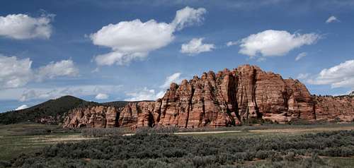
Cave Knoll is a rugged slickrock wonderland that is even more spectacular because of the abrupt transition between it and its connected neighbor Spendlove Knoll. Spendlove Knoll is a brushy, rather uninteresting summit next to the road, but the ridge connecting it with Cave Knoll suddenly changes to exposed sandstone with seemingly countless hoodoos.
The peak's name comes from a large cave-like slot at the base of the western face. This slot is easily seen from Kolob Terrace Road, and there is a picture of it on this page (primary image), but it is not so easily approached. Although the peak is entirely within Zion National Park and thus on public land, the easiest way to reach the slot, which is by hiking cross-country from the road, is blocked by private property. Thus, a very long hike entirely on park lands from the south is in order, or one must downclimb the north ridge, which does not appear to be a simple matter. In all likelihood, very few people probably ever visit the highly interesting-looking slot.
SP member
cp0915 deserves a nod here. An excellent guidebook he wrote, no longer in publication, was my information source for the route on this mountain. While I might have gotten around to trying this peak myself eventually, CP's book definitely helped me narrow my choices during my April 2011 visit to Zion.
Getting There
From UT 9 in Virgin, turn onto the Kolob Terrace Road. The road is marked with a regular street sign, and there are no big signs (as of April 2011) indicating access to Zion National Park. Drive north a little over 13 miles and find a gate on the right side of the road as you pass to the north of Spendlove Knoll. This gate is about a mile north of a cattle guard marking the Zion boundary, and there is also a picture in this section to help you locate it. Just past the gate is a parking area. Park.
![First Gate]() First gate First gate | ![Second Gate]() Second gate Second gate |
Route Information
From where you parked, go through the gate (please respect the signed request to close it) and start hiking down the dirt road. You can easily see where the brushy ridge from Spendlove Knoll makes its transition to the sandstone of Cave Knoll's western ridge. Your goal is to hike down the road about a quarter-mile and then aim for that transitional area, finding the easiest way you can through the brush between you and there. Fortunately, the bushwhacking is not that bad and does not last too long. Alternatively, you can hike half a mile down the road to a gate that at once blocks public access and also marks the park boundary, so you can stay on the legal side of the fence and follow a narrow cleared line all the way to the ridge; this will make the approach a little longer in distance but will eliminate the bushwhacking.
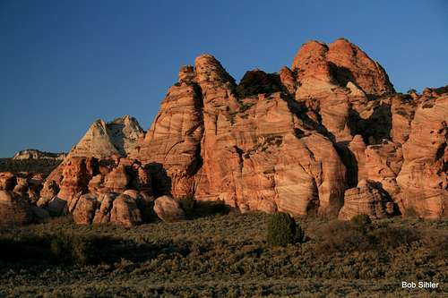
![Cave Knoll]() Cave Knoll and its west ridge as seen from the approach
Cave Knoll and its west ridge as seen from the approach
Once you gain the ridge, route-find your way to the summit and enjoy the scenery. There does not seem to be one best way, but when you cannot stay on the crest itself, the left side does, as CP says, typically go better.
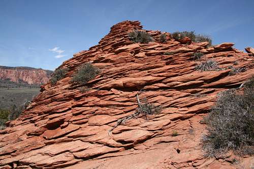
Once you reach the summit area, you will notice a group of sandstone hoodoos. The highpoint is the closest (northernmost) of them and is an easy scramble up on any side, Class 2-3 depending on exactly how you go. Near the southern end of the summit area, there is another hoodoo that appears almost as high, but after scrambling up both (the second was Class 3, again easy), I determined that the one at the northern end is indeed the highpoint.
![Summit Hoodoo]() Highpoint
Highpoint
Over about two miles, you will gain approximately 500' in elevation. There will be several spots of Class 3 terrain, but if it gets harder than that, you are making it that way and should backtrack and reassess unless you're okay with the harder terrain.
![Pine Valley Peak]() A few views: Pine Valley Peak A few views: Pine Valley Peak | ![North Guardian Angel]() North Guardian Angel North Guardian Angel | ![South Guardian Angel]() South Guardian Angel South Guardian Angel |
Red Tape
During off-trail travel, please protect the landscape by staying on rock and sand as much as possible. This prevents damage to fragile vegetation and helps slow the proliferation of use trails. When crossing vegetated terrain, please look for existing use trails and use them instead of laying the groundwork for new ones.
Camping
The Lava Point Campground is several miles north and is the nearest NPS campground. It is a small site, and no reservations are accepted. Also, it may only be accessible and open from late spring through early fall. If you are going to camp in the area, it is probably better to use BLM land off UT 9 in the vicinity of Springdale and Virgin. Campsites there are plentiful and free and are in shaded locations by the Virgin River. The Kolob Terrace Road cuts in and out of NPS land, BLM land, and privately owned land; before you try dispersed camping out there, make sure you are not on NPS land (camping only allowed in campgrounds) or private land.

 13564 Hits
 85.87% Score
 21 Votes

 First gate
 Second gate
 Cave Knoll and its west ridge as seen from the approach


 Highpoint
 A few views: Pine Valley Peak
 North Guardian Angel
 South Guardian Angel