
|
|
Mountain/Rock |
|---|---|
|
|
33.73464°S / 69.87808°W |
|
|
Hiking, Mountaineering |
|
|
Summer |
|
|
20039 ft / 6108 m |
|
|
The World's Southernmost 6000er / 20K Peak
At 6'108m (20'039ft), Cerro Marmolejo is known mainly as the world's southernmost 6000er and southernmost 20K peak. Yet the extinct Andean volcano has a great deal more to offer than just statistics, like solitude and remoteness, condors and hummingbirds, metamorphic rocks and fossils, cacti and succulents, glaciers and canyons, lots and lots of penitentes, and the clearest skies imaginable. Being both remote and cold, the mountain sees only a few ascents every year. But those who do attempt it, are in for a treat. Looking up 1800 vertical meters from camp 1 at around 4'300m to the summit of Marmolejo at 6'108m. The route is via the prominent rocky hump in the middle of the right half of the picture. Except for its north side (easily climbed on scree at its right corner), this rocky hill is completely surrounded by the vast Marmolejo Glacier (penitentes!) with its spectacular ice fall.
The first ascent on the way more practical Chilean side was pulled off in the first days of February 1943, by Mario Araneda, Luis Krahl and Walter Bachmann. In retrospect, they too opted for a difficult route, via the saddle between San José Norte (the two overlapping volcanoes of La Engorda and Espíritu Santo) and Marmolejo. As these dramatic historical photos show, they had some mean penitentes to negotiate.
The difficult north face was first climbed in 1982, and again, by a new route, in 1985.
The first ice route on Marmolejo (The Nook, WI6+, 5 pitches) was opened in February 2002, on the southwest face, by Canadians Ben Firth and Eamonn Walsh.
And finally, in 2006, the frozen waterfalls on the east side were climbed, by Austrians Harald Berger and Albert Leichtfried (Senda Real, WI7+, 6 pitches).
Getting There
") After the houses of El Morro, the track immediately rounds Morro Negro to enter the Valle de la Engorda below Cerro La Peineta (the peak in the left of the picture).
After the houses of El Morro, the track immediately rounds Morro Negro to enter the Valle de la Engorda below Cerro La Peineta (the peak in the left of the picture).The road to the alternative Valle del Yeso base camp. Photo by Matt Lemke.
From Baños Morales, where you will find the excellent Refugio Lo Valdés, or Refugio Alemán, it is another 5 kilometers (3 miles) to El Morro. Here you can leave your car and hire mules, should you wish to do so. Alternatively, leave your car at the refugio, and ask its manager for a lift to El Morro.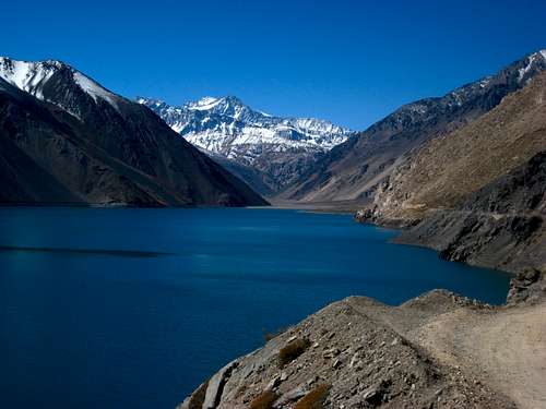
Note that you cannot drive to El Morro or the Refugio straight from the airport, as you need to buy all your food for the expedition in Santiago. Chile has extremely strict regulations on what you are allowed to bring into the country in terms of food, and the simplest summary is, that you can bring virtually no food at all.
For the alternative route to camp 1, from a base camp in the Valle del Yeso, turn left in San Gabriel, and follow the road alongside the Río Yeso and the Embalse El Yeso reservoir for as long as possible.
Normally no visa is needed to enter Chile, but when you enter Chile, your passport has to be valid for at least six more months, and you need to be able to present a document (normally your return ticket) that proves that you will leave Chile within 90 days. Your passport should also have at least one page free for the stamp. In the plane, you are handed out a form where you need to fill in your place of residence during your stay. Cerro Marmolejo is obviously not a valid entry. I entered Refugio Lo Valdés, Baños Morales, and was fine.
Route
 Me in the Marmolejo Valley, next to the Estero Marmolejo.
El Morro (2'300m) — Base Camp
 Valle de la Engorda (a little over 2'500m), as seen from the point where, having rounded Morro Negro, you enter it, looking east-north-east. In the background, from left to right (north to south), Cerro Marmolejo (6'108m), Volcán Espíritu Santo (5'692m), and Volcán San José (5'856m). Also visible are the Quebrada Norte and the Quebrada Sur, coming down from San José.
Continue an hour or so further up the valley, until you see a faint track coming down a scree slope. Go up that track. This is the most tricky part of the entire route, apart perhaps from the river crossing. You cannot really secure yourself, so be sure to bring grippy soles and trekking poles.
 between the Marmolejo Valley and the Yeso Valley, after by far the steepest part of the entire climb")
The switchbacks end at a col at 4'138m. Down the other side is the Valle del Yeso. Turn right and continue along the broad ridge for just a little longer until you arrive at an area with half a dozen prepared spots for tents. This is quite simply a perfect spot, with superb views, and on summer afternoons, possibly even running water. Camp 1 is at around 4'300m. (I did not bring an altimeter, but it was about half an hour of non-steep terrain from the pass to camp 1, so it cannot be much higher. Mantle also mentions 14'200 feet.)
Now a height gain of some 700 meters (2'300 feet) for the day may not seem much, but at this point in time, you are most probably nowhere near acclimatized, so it will do nicely. However, for those who want to do more, there are equally flat spots higher up, though none of them with equally good access to water, if my memory serves me correct.
 and Loma Larga (5'404m) in the background") Going up to camp 2 along Marmolejo's north-west shoulder, with Cortaderas (5'197m) and Loma Larga (5'404m) in the background. To the right, far in the distance, Cerro del Plomo (5'424m) can be seen.
Going up to camp 2 along Marmolejo's north-west shoulder, with Cortaderas (5'197m) and Loma Larga (5'404m) in the background. To the right, far in the distance, Cerro del Plomo (5'424m) can be seen.Camp 1 (4'300m) — Camp 2
Be warned that, once on the ice, the going gets tough, as the glacier is completely covered in penitentes.
Camp 2 (4'900 / 5'100m) — Summit (6'108m) — Camp 1
You have the top in full view all the time, so for as long as you have clear skies, you really cannot go wrong. From camp 2 it takes some 5 to 7 hours to the summit. Prepare mentally for horrendous winds. Then down again to camp 2, pack that, and further down to camp 1, which is way more comfortable than camp 2.Camp 1 (4'300m) — El Morro
Down the same way you came up. Spend an extra night at the point where the Valle de Marmolejo meets the Valle de la Engorda, if you come there too late in the day for a safe crossing. Near the end of the season, this should never be needed.Alternative Routes
There are at least two alternative routes, one via the San José high camp, and one via the Valle del Yeso. The latter is said to be very attractive as well, and makes for a much shorter first day. But the crossing of the Río Yeso is at least as harrowing as that of the Estero Marmolejo! From camp 1 onwards, the route is identical to the standard route.Dangers and Difficulties
 Aaron, our exceptionally sympathetic muleteer, carries Manuel's backpack across the imposing Estero Marmolejo.
- The river crossing is very serious indeed, and can normally only be done early in the morning. Alternatively, you could use horses.
- The altitude (6'108m / 20'039ft) poses a risk as well, but given how low you start (the Refugio Lo Valdés is at only 1'948m / 6'391ft) and how many days it is to camp 2, come summit day, your are guaranteed a certain level of acclimatization. My itinerary foresaw two nights in base camp, two nights in camp 1 and one night in camp 2. By that time, you stand a good chance of being adequately acclimatized.
- The glacier has crevasses, so for those two kilometers, you need to use a rope.
As for difficulties, the one tricky part, apart from the river crossing, is between base camp and camp 1. You go up a really steep scree slope, on which you cannot secure yourself. It requires good balance, grippy soles and trekking poles. Mantle calls this section his "three least-favorite hours", and I can only agree.
Mental difficulties include the length, the penitentes, the remoteness and the relentless wind. The good thing is, mentally, that there are no false summits.
Red Tape
Coming from the Chilean side, and that is the only practical way, you need two permits, to be shown at the police station in San Gabriel. You have to apply for these two well in advance. Going with a tour operator, you would normally leave this hassle to them.If you still want to organize this yourself, go to the DIFROL homepage, and provide the requested information. Once you have the DIFROL permit, go or write to the Chilean border control agency (Dirección Nacional de Fronteras y Límites del Estado) in Santiago. The address is: Bandera 52, Santiago Centro, Phone (2) 671 41 10, Fax (2) 697 19 09.
Both permits are free of charge. Since there is no practical access from Argentina, there is, unfortunately, no way around this bureaucracy.
When to Climb
 Camp 1 on the evening after a sudden whiteout, with Marmolejo's summit pyramid in the background.
Being the southernmost 6000er / 20K peak in the world, it is obviously a seriously cold mountain. Therefore, any ascent in the period April—October must be considered a very perilous undertaking. Having said so, I know of at least two ski ascents in October. See the External Links section.
Mild phreatomagmatic eruptions were recorded for the San José volcano group in the 19th and 20th centuries. So perhaps you might want to check for any recent volcanic activity as well. The chances that any of those volcanoes is going to erupt are exceedingly small, but seeing that Chile is regularly hit by strong earthquakes, it is at least in theory, not entirely impossible.
Camping
, with Cortaderas (5'197m) to the left") Manuel Bugueño in camp 1, in front of Loma Larga (5'404m), with Cortaderas (5'197m) to the left.
Manuel Bugueño in camp 1, in front of Loma Larga (5'404m), with Cortaderas (5'197m) to the left. Camp 2, or high camp, at a little over 5'200m. A horizon full of 6000ers. To the right Tupungato (6'570m). In the distance Aconcagua (6'963m).
Base camp is at around 3'600m, near the end of the Valle de Marmolejo. A tiny stream coming down between Marmolejo and Volcán La Engorda provides clean water.
Camp 1 is at around 4'300m, on the north-west ridge of Marmolejo, between the Valle de Marmolejo and the Valle del Yeso. There are a fair number of flat spots surrounded by low stone walls. On summer afternoons, there is running water below a nearby penitente field. Early in the morning, you may still have to resort to melting the tip of a penitente. This camp is very comfortable and offers amazing views all around.
Camp 2 is anywhere between 4'900m and 5'200m, either at the point where you enter the glacier, or on an island on the glacier itself, or at the point where you leave the glacier. Here you will always have to get your water from melting ice. Cold, wind and thin air tend to make this camp extremely uncomfortable.
Since camp 2 is so uncomfortable, some parties opt for two camps rather than three, with camp 1+ halfway between the normal camp 1 and camp 2. You cannot miss this spot, as it is right on the way up, left of the track. It is perfectly flat, but only offers place for one or two tents and I don't seem to remember good access to water. Actually, it was near where this photo was taken. I guess it is at around 4'600m.
Literature
- John Biggar, The Andes — A Guide for Climbers, ISBN 0-9536087-2-7, p. 220—221.
- Hermann Kiendler, Die Anden — Vom Chimborazo zum Marmolejo — Alle 6000er auf einen Blick, ISBN 978-3-936740-36-3, pp. 360—363.
- Doug Mantle, The Last 20K Peak, in: The Sierra Echo 59(2015)1, 22—24.
External Links
 to the far left, via Tupungatito (5'640m), Alto (6'148m) and Piuquenes (6'019m), to Piramide (5'520m) to the far right") Panoramas don't get much better than this. From camp 1, the view ranges from Cerro del Plomo (5'424m) to the far left, via Tupungatito (5'640m), Alto (6'148m) and Piuquenes (6'019m), to Piramide (5'520m) to the far right. The high snow-capped peak farthest away, in the left half of the picture, could be Polleras (5'993m), but I'm not sure.
Panoramas don't get much better than this. From camp 1, the view ranges from Cerro del Plomo (5'424m) to the far left, via Tupungatito (5'640m), Alto (6'148m) and Piuquenes (6'019m), to Piramide (5'520m) to the far right. The high snow-capped peak farthest away, in the left half of the picture, could be Polleras (5'993m), but I'm not sure.- The Andes Handbook entry.
- Weather forecast.
- Refugio Lo Valdés, or Refugio Alemán.
- The story of the first ascent from the Chilean side.
- My own SP trip report.
- Ben Collins' trip report, with some daunting penitente photos. Turns out, they were there, just one month before we were.
- My guestbook entry for my trekking agency's web site.
- The story of a ski ascent. My guide at the time, Manuel Bugueño, told me, that he had done Marmolejo on skis as well.