
Comments
No comments posted yet.
|
|
Trip Report |
|---|---|
|
|
Jul 31, 2011 |
|
|
Hiking, Mountaineering |
|
|
Summer |
We were just west of Amargosa Valley when we saw the bats ...
Well, we had no acid and were headed in the wrong direction from Vegas, but when we saw the hitchhiker I had a Hunter Thompson moment all the same.
"Whadaya think?" I asked Jay.
"Your decision."
I pulled over and reversed a hundred yards or so on the shoulder of US 95 to save the guy some jogging with kit in the 109F-degree heat.
He trotted up, and I had him toss himself and his gear in the back seat: "Where are you going?"
"That way," he said, pointing up the road.
"We're headed for Bishop tonight."
"That's exactly where I'm going."
I like a dry sense of humor. Brad, who was taking time off from studying environmental engineering, had spent part of the summer in Costa Rica. After flying into Houston, he paid thumb fare west, with a plan to end up in Vancouver to visit friends, then hitch back across Canada to home in Ontario. He was 23, the same age I'd been when I was thumbing up and down the East Coast.
He told us he'd been standing on the road for around four hours before he decided to start walking. Not much along the highway in Amargosa Valley--truck stop and brothel museum were the highlights. He was burned brown from the sun and later regaled us with a tale of a motorcycle wipeout (he was riding behind the driver) on I-15 in Vegas.
Jay and I were on our way to an ill-defined ramble in the Sierra Nevada. We'd had a fine time up Pine Creek in '08, just the two of us, and he was ready for another go. We'd hoped to reserve permits for Bishop Pass to get us to Dusy and/or Palisade basins, but had to get South Fork of Big Pine Creek since a heavy snow year had a lot of people postponing July trips until August. We changed it to Bishop Pass by showing up early at the ranger station in time for a walk-up permit the day we planned to pack in, Thursday, August 4. I had no rope, and Jay don't climb, so I planned to scramble whatever looked good. I'd been in Vegas for work, and he'd flown out that afternoon to meet me.
Meanwhile, I'd never been this way before, and we were enjoying the drive through the desert, with landmarks staying in view for what seemed like hours. Had one line of sight of the road that I clocked at 18 miles. Kept thinking about the "The Hills Have Eyes" and "Blood Meridian." Temperatures were well over 100 F till we turned north at Beatty.
We meandered on, yacking away with Brad, but missed the turn at 266 (none of us saw a sign, and didn't see one on the return trip when we checked), and by the time we realized it, we were far enough north to merit continuing to Tonapah, where we stopped for gas and elk jerky. Always good to visualize a Little Feat reference anyway.
Dusk was upon us as we entered California, where we came across an inspection station looking for fresh fruit. What's up with that? Arrived at Wilson's in Bishop about 8:45, where Brad got some advice on wild camping from the staff. Jay and I were going to crash at a motel and offered him a roof, but he declined. We dropped him off near the city park and said so long.
Dinner at Yamatami, to Von's for a shop, then check in at America's Best Value Inn ... Yamatami was great, but I don't know about the room "value."
After breakfast at Denny's, we hit the ranger station and got our permits, stopped at the hotel to finish packing, visited Wilson's for a new headlamp, as my old one had crapped out. We drove to the Bishop Pass trailhead, getting a late start on the trail at 11:35. Guy told me we were late packing in, and I said we were only heading to Dusy Basin that day. "You know that's over a 12,000-foot-pass, don't you!?" Duh. Gotta indulge the tourists, I guess.
Took a brief stop at the switch-backs before Long Lake, and another rest at 2:30 before the final slog to Bishop Pass. We reached the top at 4:15 and took a break to enjoy a now-familiar vista.
In the past, we'd passed through Dusy Basin on our way to the Palisades. Maybe I'm getting old, but we came to a mutual decision to spend our time there and explore a few corners, so we quickly found ourselves in vacation mode. I have my own ambitions, but Jay's always been a trooper, and with his commitment to join me that week, I wanted him to enjoy our days up here and not get dragged around too much on whatever I was chasing. As it turned out, he ended up on probably the toughest terrain he's encountered on any of our trips--but I get ahead of myself.
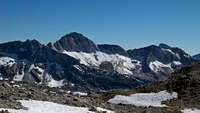
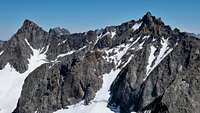
Around 5:20, we found a site in upper Dusy Basin after we started losing the trail in snow fields on the way down. We wanted to camp high, so we cut east a bit to near the stream from the pass and set up on a promontory at around 11,700 feet with brilliant views of Agassiz, Winchell, Thunderbolt, North Pal and the ridge running south to Columbine and Isosceles Peak, to the Giraud-defined divide to the South.
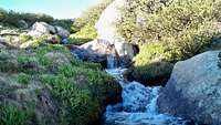
Camp was in earshot of a stream that played background music and gave us water the entire stay. We were in our bags before 10 under cloudless sky, a waxing moon and the Milky Way wheeling about. I'd brought a tent along, but I just used it as a pillow this and the following three nights.
Spent a leisurely morning with our marmot neighbors. Our camp lay on the bee path for several, and we enjoyed their company for the duration.
As I mentioned, for us, Dusy Basin had always been walk-over country. It really is a wonderful piece of mountain scenery, and I recommend it as an introduction to newcomers for the pleasures found in the High Sierra; or those wanting a getaway when time is short. Though maybe a little more than a hundred yards from the trail into LeConte Canyon, a granite bench hid our site from immediate passersby, even if we saw a few people each day from farther away on the trail. Didn't feel remote, but felt private. The basin offers all sorts of such corners.
At a quarter of noon, Jay and I strolled up a peaklet just west of Bishop Pass with a class 3 summit block. I'd wanted to put eyes on a little more of the approach to Columbine Peak--its Northwest Ridge looked like it would be a fun ropeless jaunt, and our little summit offered a nice look over to the West I hadn't seen before. After returning to camp we walked South to the edge of a bench overlooking the lake along the main use trail between Thunderbolt Pass and Bishop Pass Trail. Got a look at enough of the cross country to Isoscoles Pass, where I'd access the Northwest Ridge, to have a plan for the next day.
Did a major water-pumping session after we got back, since I didn't want to do it in the morning before we left for Columbine. Topped off both pack bladders, all the bottles, and my big collapsible container. Pumping water's become something of a meditative thing for me. For a long time, I'd done it myself, and it always was a time to let my mind wander in a beautiful setting beside a tarn or clear-running stream. Even though Jay always helps now, which makes it easier, it remains a bit of an outer-body experience. Before I do it, it's a chore, but when I'm done, I'm totally relaxed.
The moon's sinking fairly early this week, so when I wake during the night it's to a field of stars.
Another relaxed start to the day, breakfast with a hummingbird for company, and setting off South and then East from camp at 10:15.
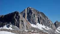
Headed up the bench between the largest upper Dusy Basin lakes, and topped out to a great view of Isoscoles and Columbine from a perspective I hadn't seen. Lots of great camp sites among the lakes and tarns below the two peaks. We turned up the drainage between the peaks at a moraine leading to Isoscoles, which was a bit too early, putting us on big talus for a longer time. Climbed snowfields to just below the pass, where I did 30-40 feet of class 3 to the top while Jay went left to take an easier line before climbing back down to the saddle, which he reached around 12:30.
Secor lists this pass as an alternative to Knapsack between Dusy and Palisade basins, but does not recommend it--found out why, certainly not something I'd want to do carrying a big load, but it let Jay push his comfort zone and come back in one piece, and it's the best way to the Northwest Ridge from where we started.
Jay stayed put, and I headed up at 1, reaching the summit 55 minutes later, stopping along the way to chat with a couple that had just moved to Bishop with the Forest Service. The first part of the ridge is mostly class 2. After my encounter, I stuck near the crest, which eventually puts one in class 4 ground. I'd just climbed some smooth chimneys formed by large blocks when I arrived at a window that looked out over the obvious clean wall on the West face of the ridge. I didn't fancy downclimbing what I'd just come up, but to proceed meant a move across the face into a wide crack system that looked dead easy once I got there, even if there'd be hundreds of feet of air under my heels for maybe 20 vertical feet.
If I'd had been on belay, I'd hardly have paused, I thought. That settled me since even when I'm on belay, I tend to approach the moves as if I'm not--anyhoo, a deep breath and concentration on the matters at hand got me into the crack and up to a good ledge. A few minutes later, I was on top, where I found the couple I'd met before sitting on the summit block, which leans out over the East face of Columbine. They'd taken an easier way that dropped off the ridge crest along the top of the East face. Went down that way after spending 20 minutes enjoying the summit, and reunited with Jay at the pass a little after 3.
We started back down at 3:50, and went all the way to the bottom of the drainage, probably could have cut back Northwest across talus earlier, but we enjoyed the walk back to the top of the bench to the West that gave us line of sight to our camp. We ambled into camp at 6:15.
It was a nice little mountain day out, and our limbs were feeling it, so we kicked back for a while after hydrating. Even though it was a class 3 ridge, I felt as if I'd gotten some proper climbing in, especially with the class 4 section. It was one of those times when spending a lot of time out here came to bear head-wise. Jay'd been his usual non-complaining self even when I knew he was sick of all the talus on the way up. He followed me through some terrain that I believe was the hardest he'd seen in 9 trips.
Around 8 we were waiting on our spaghetti to cook, having enjoyed our cheese and Triscuit course--a tradition on our trips, and after a big day in the open tastes just incredible, feeding fat to a hard-used body. The spaghetti wasn't half-bad for freeze-dried. Jay did note that at home he didn't think he could ever "choke this stuff down," but it works fine out here for some reason, at least for me.
Figured as long as we were here I'd climb Agassiz the next day--I'd always wanted to see the view of the Palisades and the Big Pine drainage from there. Jay said he'd make the call in the morning on whether he'd go. Just wanted him to do what felt right--he'd worked his ass off today.
Slept in. Joined for breakfast by one of the marmots, who entered our small "perimeter". Told Jay I was glad it felt it could make itself so at home before remembering that we're the visitors here. Don't worry, buddy, it'll all be yours again tomorrow.
We got to the base of Agassiz at 11:30, where after a 10 minute break, Jay decided to turn around and explore around camp. I headed up the talus, staying to the right of the chute for more enjoyable movement where I could use my hands, and stopped for a bite about level with Jigsaw Pass around 12:30, where I had perspectives I'd never seen on the lakes below Bishop Pass. I reached the summit of Agassiz at 2.
All the talus made the climb seem longer, but as I figured, the views made up for the slog--the entire High Sierra, and the cirque from Temple Crag to where I sat is spectacular. I could see all the regions I'd ever visited, and it was great to be on this earth. I'd never seen the Palisade Glacier so full at this time of year--white all the way down to the moraine lake.
I started back down at 2:50, reaching the base at 4:40. I descended one chute North from where I came up before crossing back to my original chute at a prominent gap above the bottom two snowfields. Went cross country from the base to camp, arriving at 5:10, where good ol' Jay had already pumped my collapsible water container full. Agassiz by the standard route is one of those climbs that's better in retrospect, since the summit view is what sticks in memory. The climb itself is relentless class 2, and I found the descent especially tiring. I think Jay made the right call for himself.
I knew what I was getting with Agassiz, but while the talus tedium didn't disappoint, a profusion of flowers along the way, especially polemonium, helped keep my spirits up along with the occasional wildlife sighting. Mostly pikas, but just before the summit, I saw a shadow pass before me. When I looked up I saw what appeared to be a northern gosshawk cruising about 50 feet above--pretty dang cool, that.
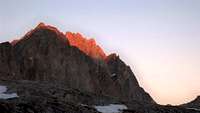
We ate dinner as the last alpenglow hit North Palisade and Starlight. I make sure to watch the light on the peaks till the very end on my last night in the back country--save one for the memory bank. Had some good moments to carry me through till our next trip. Tomorrow: nice walk, a shower at Parcher's, grease-fest at Jack's and a ride through the desert.
Awake by 5:30, but I just lay in my bag watching the peaks and landscape light up one more time, enjoying my last morning in this fine spot, and looking forward to a walk on a gorgeous day. We'd seen one cloud the entire stay, a tiny one in the distance that quickly dissipated. Without a tent to break down, packing up's a breeze, so even after taking our time with breakfast we leave by 9:15.
We stopped for photos 20 minutes later at Bishop Pass, where I gave some hikers info on Agassiz. At 11:30 we stopped where we took our first break on the way in. We met Kurt Wedberg taking a group into Palisade Basin for a climb of Starlight (saw later where everyone made the summit--well done!). I told him how helpful his trip pictures had been, and he was kind enough to tell us to e-mail anytime for conditions. Back to the trailhead at 12:25.
A Chairman Mao wind-up watch I'd bought for $5 in Shanghai that I use on my trips had gone kablooey, so I ceremonially consigned him "and his tyrannical ways to the dustbin of history" in the trailhead dumpster.
Showers at Parcher's, Ranger Station to leave bear can, Sierra Mountaineering to drop off extra fuel (can't take it on the plane), and Jack's for fat. On the road at 2:40, taking 395 South to Big Pine, where we picked up 168 East. We took 266 at Oasis 51 miles into the trip, and U.S. 95 South 43 miles after that. Stopped at 5 in Beatty and pulled into Hertz return at McCarran Airport in Vegas at 7 p.m., after filling the vehicle. Clocked it at 270 miles.
Smooth drive through maybe the most sparcely populated road accessible country I've ever seen. I remember coming over a rise past Oasis and saying "We can probably see where 95 is from here." Turns out we could, and then some. Wild, spooky country. Between 395 and U.S. 95, We saw fewer than five cars on the road, and one of them almost managed to cream us since the driver was gawking at the view of the Sierra from a rise (just east of Oasis, I think) as she was coming around a sharp turn.
Sat in the airport feeling strong and clean, with a dose of whatever it is I need from these trips to see me through till next time.