Some Background
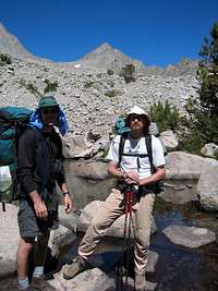
Before this summer, I had made six trips for five or six days in the back country to different parts of the Palisades. All those included my first climbing partner, Gene, and Jay, a former coworker who's also become a friend through our excursions. Four included my godson, Roy, who gained an appreciation of what the mountains have to offer.
This year, however, it was just Jay and me, as Gene's job and the start of Roy's senior year at UNC-Asheville kept them home. My own work prevented a trip earlier in the summer when everyone was available. Another difference was that each previous trip, I'd gone with climbing in mind, and Gene and I typically had a couple of specific routes we wanted to do. Jay enjoys cross country travel in the back country, and had scrambled part of the way up Thunderbolt Peak one year, but he's not into anything technical or very exposed.
So, my seventh trip to the Sierra Nevada was different from the start, and we also would visit a new region, a loop out of and back into Pine Creek Pass trailhead. We planned a general outline for our Sunday-in-Friday-out schedule, but as neither of us had been there before, we were flexible. I definitely wanted to see Granite Park and Royce Lakes, and bag a couple of non-technical peaks along the way. Mainly, we wanted a few days of solitude in places where wind, water and birds are the only things breaking the silence.
It also would be the first time I'd spent a week out with just one other person. I figured Jay would be a good partner--he's comfortable with silence, and when he does say something, it's pretty intelligent. Despite his quiet demeanor, he has a sharp sense of humor. He never complains, and loves being out in the mountains. He avoids vegetation when traveling off trail.
Saturday, August 23: Reno to Pine Creek Trailhead
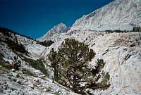
![Waterfall on Pine Creek Trail]() A waterfall provides scenery and background music to the upper portion of Pine Creek Pass trail's switchbacks
A waterfall provides scenery and background music to the upper portion of Pine Creek Pass trail's switchbacksJay and I met around noon at the Reno airport, having taken separate flights from North Carolina. Boarding my connection in Phoenix, I was thinking that Reno had some pretty wild people. Maybe it does, but it turned out there were a lot of passengers on my flight bound for Burning Man, which officially started the coming Monday. There was an information table for the festival near luggage claim, and a lot of folks milling about looking to rendezvous with fellow travelers.
Luggage claim gave me a scare when the belt stopped rolling, and the Phoenix flight got replaced on the monitor--my gear duffel hadn't come out yet. A few minutes later, my flight popped back up, and out rolled the duffel.
At the Dollar counter, the car rental agreement had a temporary codicil stamped in red, indicating a charge for "excessive filthiness." Since we we'd be dusting up the car pretty well, I asked the counter lady what "excessive filthiness" meant. "Oh, that's just for Burning Man," she answered.
We loaded the car, stopped at Heidi's in Carson City for a meal, and headed down 395, picked up our permits in Lee Vining, and reached Bishop around 5:15.
After getting fuel and a better map at Wilson's and the week's food at Von's, we ate dinner at Namatami--mmmm--and drove to the Pine Creek trailhead. We walked down along the stream and pitched a tent, but we threw down bags outside and watched the stars come out with running water for background music, for the first of six nights and days I'd spend completely in the open.
Though it had a pack station and the lot was fairly full for the weekend, the trailhead felt more off the beaten path than those at Big Pine or Bishop Pass. Didn't see a thing after Rovana except darkening peaks and canyon walls.
Being a city dweller, I have learned to get the most out of my time in the hills from a mental standpoint. When in the back country, there's not much you can do about work, the state of the world or anything else so why think beyond safe movement and soaking up the beauty? I've learned just to let it all go, and I was in full vacation mode that evening, having been well on the way since starting the drive down from Reno and passing by familiar peaks and landmarks along the Owens Valley. Also got my first look at the Sawtooth Ridge.
Sunday, August 24: Trailhead to "The Shire"
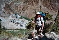
![Pine Creek tungsten mine]() A tungsten mine is a strange backdrop for much of the Pine Creek Pass trail's first leg.
A tungsten mine is a strange backdrop for much of the Pine Creek Pass trail's first leg.A leisurely start, not heading up the trail until 9:45. We were in no great hurry, and planning only to camp somewhere after we'd taken the Italy Pass fork west off the Pine Creek trail. I'd figured this trail would have the sting on the front from what I'd read and from looking up from the trailhead--around 2,500 feet of elevation gain in the first three miles, pretty different from what I'd been used to in the Big Pine forks and Bishop Pass trails. Note to self: Even if you're in no big hurry, get the first leg of this trail done earlier in the day during summer.
An old tungsten mine provides graphic visual indication of elevation gain, and adds a post-industrial, Mad Max atmosphere to the mostly shadeless (at that time o' day) climb on the switchbacks that begin soon after the start. The payoff lies above at the first of the Pine lakes, with an interesting striated peak to the North, and a view of the Sierra Crest from Pine Creek Pass to Royce Pass.
Gentle climbing to the flats around Upper Pine Lake and then up to the junction for Italy Pass, stopping about 3:40 atop granite benches west of Honeymoon Lake where we made our camp. Nice shade on the trail from just before first Pine Lake.
I was happy not to have been toting climbing gear/rope, and my pack was lighter than it had ever been. We stayed hydrated all day, and once we stopped I realized I felt better than I ever had the first day out. It also helped that we were at a little over 10,500 feet, versus the 12,000 we'd have been at, say, in the Palisade Basin.
Jay later dubbed the lovely meadow west of our camp "the Shire." We stayed out of it as it was signed a "reclamation area." Our site offered an assortment of granite sofas, was within earshot of water, and to the east had a fine view over Honeymoon Lake, with the Sierra Crest and Royce Pass to the south. The beauty of the place made changing plans to stay more than one night pretty easy after Jay pointed out that the soles of his Asolos had begun to delaminate.
All we had for repair was duct tape, which might do on the trail, but we'd considered going over Italy Pass and back into Royce Lakes perhaps via one of the Bear Lake-area passes. I decided to hike to Royce Lakes the following morning to take look at what we might be doing if we went over Italy Pass.
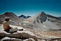
Monday, August 25: Morning Hike to Royce Pass
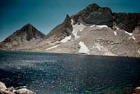
![Royce Pass]() Royce Pass from our camp site for three nights.
Royce Pass from our camp site for three nights.![Merriam and Royce]() Merriam and Royce peaks from Royce Pass.
Merriam and Royce peaks from Royce Pass.Slept well Sunday night and later than I ever have in the back country, till around 9 a.m. before I really got going. Jay and I ate breakfast and talked about what to do. We left camp at 11:15 heading toward 11,700-foot Royce Pass. Jay turned around atop the first set of benches to go work on his boots some more. I continued on to the pass, but stayed a little too far east and ended up crossing some talus to get back toward the usual way.
I stopped just before the pass to put on my fleece as I could tell it would be very windy at the top. The largest of the Royce Lakes is almost level with the pass to its south, and beyond is an impressive trio of peaks--Merriam, Royce and Feather. Completely clear skies. Saw and waved to another hiker around the pass, who looked as if he'd come from the southeast.
I walked down to the lake and around to the west a bit to check out the passes west of Feather Peak. They looked like nothing I'd want to climb or descend in taped-together boots, so I had a strong guess Jay wouldn't either.
Back down to camp, and a lazy afternoon spent reading and watching the light change our surroundings as the day progressed.
Among mountains and big landscapes, during my first trips to the Sierra I tended not to notice more immediate details, but one of the things I've enjoyed most in recent visits are the "small" moments, such as a single flowering plant holding on amidst what appears barren ground. Had one that afternoon as I was sitting above Honeymoon Lake, intermittently reading, but mostly taking in my surroundings and listening to the wind on the way up Pine Creek, when a white and black bird alit on the crown of a tree directly overhead and started a conversation with another nearby, chatting away for 15 minutes before flying off.
I made a mental note to find out more about the wildlife in these mountains beyond the obvious marmots and pikas, and birds of prey. I've always enjoyed Norman Clyde's accounts of his climbs, not only because he was the baddest of bad asses, but for the knowledge he displayed of the flora and fauna he encountered, described in great detail as he made his way toward the peaks.
During dinner, Jay told me about the longest meal he'd ever had--a first-time face-to-face meeting with two acquaintances he'd met through work and their wives. They went to The Melting Pot, a fondu restaurant in Greensboro, which makes for what I'd say is too extended a dining experience.
"Topics of conversation eventually dried up," he said, adding that the better part of the meal was the other two guys--who knew each other well--trading "Hey, remember when we ..." stories. The whole thing lasted more than three hours. I mentioned to Jay that I didn't believe I had three hours of non-stop conversation in me even with people I knew well. Heck, maybe we're just boring old misanthropes, but I've gotten to where I sometimes just like it quiet.
Jay's boots were in pretty bad shape despite his ministrations, so we decided to day-hike tomorrow to Italy Pass, then on to Royce Lakes via Royce Pass on Wednesday, as that approach is quite easy. If Jay's boots were completely shot after Italy Pass, I suggested we pack out on the trail and just get a camp site for some day hikes (I had a pair of approach shoes in the car that he could use). Wouldn't be like the back country, but in my book, you can't go wrong with a day out in these mountains.
Jay's stove also went on the blink. Finally, bringing my canister stove along as a backup paid off. Jay's comment in light of boot and stove issues: "I'm glad I didn't bring a tent."
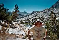
Tuesday, August 26: Day Hike to Italy Pass, Mt. Julius Caesar
![Seven Gables]() Jay at Italy Pass with Seven Gables in the distance.
Jay at Italy Pass with Seven Gables in the distance.As fine a day as I've spent in the mountains in terms of scenic beauty and variety.
We woke to another cloudless morning and headed for Italy Pass at 10:15. The trail took us around the north side of the Shire past a very nice waterfall to climb up through two more levels of meadows before crossing into Granite Park proper. We detoured onto a high point at the eastern end of Granite Park between the Chalfant and Granite Park lakes, where we stopped a while for a snack and a sip as we enjoyed views of Granite Park Spire (fine looking route there, Chief, even if at sustained 5.10 in the BC a little out of my league) and Royce and Feather peaks looming to the south above the crest.
Climbing easily out of Granite Park, the trail fades in and out, but the way's well-ducked and simple to follow, and at any rate the pass is directly ahead. We ambled atop Italy Pass at 1:25, where we met a group of cousins and brothers heading east--saw them again later, camped on the far side of Honeymoon Lake, from our spot atop the benches.
After sitting for a bit, I decided to bag Julius Caesar, and headed up the south ridge from the pass, soon departing the class 2 sand slog on the slope to stay on or near the ridge line for more enjoyable, at times third class, movement--had to at least get my hands on some rock this trip. Hit the false summit and traversed over to the true summit, arriving at 2:35, and to a fine view encompassing Bear Creek Spire to the north, Mount Humphries and the Palisades in the distance to the southeast, a great perspective on the Royce Lakes triumvirate nearer by, and a good look at Seven Gables south of Italy Pass. Didn't see a summit register anywhere, but didn't really search all that hard.
My throw-away camera ran out after one shot from the summit--can't believe I hadn't brought my second one--so I had to file the best views in the memory bank. Note to self: Break down and buy yourself a decent digital camera (The absent Gene had always been our primary photo-documentator).
We strolled on back to camp, starting down the pass at 3:30 and getting back near six after a couple of stops to soak things up.
Jay and I had a cold dinner that night, as he still couldn't get the stove to work, and I wanted to save the gas canister for Royce Lakes, where I figured it might be a bit colder at night and a warm meal would be better appreciated--turned out it was just as mild up there, but what the heck. Didn't really matter, since in the back country, both Jay and I view food as fuel. I did think of Gene and Roy, then, and indeed I missed their wistful musings during past trips on the healing power of steak, pie, waffles and such that would grow ever more elaborate as the week progressed.
The weather gods were smiling on us again, as they had the two prior trips--brilliant blue skies every day and a vault of stars every night, with the moon rising well after midnight, a quarter-plus and waxing. Skeeters had been light and remained so all week. Last year's trip to the Palisade Basin was completely mosquito-free after a late freeze in 2007, and it was incredible the difference that made after getting used to having them around.
Did see some fair weather clouds in the afternoon starting on Monday, which continued to build for the rest of the trip.
Wednesday, August 27: "The Shire" to Royce Lakes
![Jay in Granite Park]() Jay in Granite Park. He soldiered through the trip with a pair of boots worthy of the retreat from Moscow by the end.
Jay in Granite Park. He soldiered through the trip with a pair of boots worthy of the retreat from Moscow by the end.We left our first camp site at 9 a.m. and made the easy climb to Royce Pass under another clear sky. After reaching the pass a little past 10:30, we contoured along the northeast sides of two of the Royce lakes to a site near the northeast end of the southernmost lake, with Merriam's North Buttress rising in fine form directly across the water, arriving at 11:40 after stopping for photos and a snack along the way.
Across the broad plateau above French Canyon to the southeast of Merriam, Humphries presents a stern profile, the Palisades farther on, then what I took to be Darwin in the nearer distance. While we hadn't set any speed or distance records for ground covered, we decided to kick back. I'd thought about bagging Merriam, but decided to spend the afternoon hydrating and taking it easy, especially since the weather was holding so well.
We pumped some water, and I realized the bladder that came with my pack had sprung a leak at a seam, so it's done after nine years of service. I get attached to stuff like that, especially an item that's been with me since the first trip I organized in '99--last year I had to dump a collapsible jug that made it through its last trip with the help of a lot of duct tape. I drained the water bag for the last time and said "adios."
Royce Lakes is very different from our previous site, more than 1,000 feet higher and well above the tree line. It was nice to get back up beyond the timber again.
We got semi-active after all. I wanted to see the lay of the land beyond the rim of the plateau, so Jay and I strolled over to two high points southeast of camp overlooking French Canyon, with the second location providing a view of our return route over Pine Creek Pass. Our camp site appears maybe two miles at most, more like a mile and a half as the crow flies, from the pass, and once over, it's a little more than 8 miles back to the trailhead, just about all downhill.
After returning to camp, Jay and I swapped books, having finished the ones we'd bought. The clouds were building faster and thicker than on previous afternoons, so it looked as if Friday would be a good day to walk out after all.
Had another "small" moment that evening. I'd walked down the lake to scope the scraggy approach to Merriam/Royce col from a different angle. The peaks were catching the last half-hour of sun they'd get that day, and trout were popping all over the lake to feed in the evening light. Sweet.
Thursday, August 28: Merriam Peak, Royce Lakes to Upper Pine Lake
I've never been much of a peak bagger, but I'd enjoyed my jaunt up Julius Caesar and was looking forward to Merriam, which was an inviting sight from our camp. Jay and I headed out at 8 a.m. and reached Merriam/Royce Col less than 45 minutes later. Jay decided to head back down.
Once again, I stayed on or next to the ridge for some class 3 moves, and the primo view of the North Buttress route. Paused for a shot of a wild looking block perched directly atop the NB, then cut to my right to approach the summit area--I was watching my feet on a third class move, and and managed to bang my head pretty hard--"That's gonna leave a mark," and it did.
I sat for a moment before moving on to a false summit, then traversed to the true summit. Another spectacular view, especially of Bear Creek Spire's south face, which had peeked at us from time to time during the trip. A fun summit register--saw recent entries from the Sierra Challenge and a new route from Peter Croft on the North Buttress. Lots of warnings not to underestimate the ridge between the NB and summit. I also saw references to "the world's tallest top-rope" and lines fixed all over the NB. Anyone know what was up with that? They'd gone by the day we arrived.
I did the sand-ski down most of the way to the col. On the way back across the talus, I got into one of those "zones" where I was bopping along the rocks without breaking stride most of the way across. Got back to camp at 11:25, and we left an hour later after some lunch.
An easy stroll toward Pine Creek Pass, though we kept a little too far left and ended up negotiating a few benches, still fun. Further out on the plateau, we looked back for a glimpse of Feather Peak's red racing stripe. Jay pointed out seven or eight doves along the way that paid us no mind as we walked past.
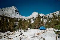
The clouds were really starting to build, and by the time we hit Pine Creek Pass--where my second camera ran out of film--there was intermittent cloud shade on the trail, the first time that had happened all week. It looked like thunderstorms within the next few days. We made camp on what looked like is an island in times of high water on the northwest end of Upper Pine Lake at what we figured was a little over 10,100 feet. Another sweet spot with the Sierra Crest to the south and the sun catching Broken Finger to the north.
I'm always a little wistful on the way out. I do enjoy the strong, clean feeling of coming back down into lower elevations after a few days higher up. Always adds to the end of the trip. I'd left things in about as good a shape at work as I ever have, and found it easy to get right into vacation mode without decompressing from the work frame of mind.
I was happy to have bagged a couple of peaks this trip. Rather than be disappointed by not trying anything harder, I'd decided to just go with the week for what it was, and it was as fulfilling in its own way as a more climbing-oriented trip.
We plan a cold breakfast tomorrow so we can wake up and go, and hang the food.
Jay was as perfect a partner as I could ever have for a ramble such as ours, and we passed the week without a single tense moment I know of, the sort that can arise when you're one on one with someone for a few days.
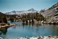
Friday, August 29: Upper Pine Lake to Trailhead, Reno
![Upper Pine Lake]() Looking south from near our camp site on Upper Pine Lake.
Looking south from near our camp site on Upper Pine Lake.Up early this morning, out of my bag by 5:45. The light started coming on, and the view around our camp was in clear, yet soft focus, with green emerging from the gray, which in its turn bloomed into white as sun illuminated granite. I looked up to Royce Pass and the peaks lighting coral/gold on either side and remembered the joy of being a tiny speck in such a landscape. I got to sleep late the night before, and I suppose it's the same sense I have the night before I depart for one of these trips.
We started down at 7:25 and reached the trailhead at 9:35. We drove back to Bishop, where we stopped to drop off our remaining fuel at Sierra Mountaineering--we couldn't take it on the plane, and figured it would be put to good use there. After finding a shower, we ate fat at Jack's and stopped by the Looney Bean for coffee.
We left Bishop at 1:10 and returned to Reno, taking for the first time the June Lake Loop, arriving at the airport at 5:30. Our scheduled departure was 6 the next morning, so we'd planned on dossing in the airport, anyway, but we still checked stand-by for earlier flights. No go there, so we read, ate and watched people making an early departure from Burning Man filter into the airport before getting some sleep.
Epilogue
![Gene and me]() Gene and I headed for a bivy in the South Fork of Big Pine Creek back in 2004. Ah, memories.
Gene and I headed for a bivy in the South Fork of Big Pine Creek back in 2004. Ah, memories.I remember in '04, when we were at Von's stocking up for what we'd hoped would be the Palisade Basin. A fit looking older woman--I figured she was 65 or so--stopped us in the aisles and said, "You boys must be going into the back country." I told her yes, we think Palisade Basin. She talked about how much she loved it back there, adding that a stroke two years ago had kept her out of the mountains.
I asked her just how old she was. "I'm 84," she said. I thought about the memories she must have, and how we were getting a chance to work on some of our own.
Due to lack of walk-in permits for Bishop Pass and a couple of other trailheads, we ended up that trip on our first visit to the South Fork of Big Pine Creek, but without any gear for the nice looking ice on that side around Norman Clyde and Mount Williams or an ice axe for Middle Pal Glacier. I'd figured our schedule would be good for walk-up permits, but we got shut out on our preferences. Gene and I ended up following our nose after a bivy above Elinore Lake, and climbed what turned out to be a new route on the east face of Gayley for what in some ways was my most satisfying mountaineering experience.
After not getting our first choice of trailheads, it was a lesson that's served me well when things don't go exactly as planned: You can't go wrong with a day out in the Sierra Nevada.


Comments
Post a Comment