Overview
Chimtarga (5489 m) is the highest peak in the
Fan Mountains. Located near the Mutnye Lakes, it has no trivial walk-up route to the summit. The ascent routes start either from the Mutnye Lakes or from the Right Zindon valley. The Right Zindon valley can be reached either by hiking in from west via the Big Allo Lake, or from east via the Mutnye Lakes by crossing over the 4750 m high Chimtarga pass, which lies between the peaks
Energia (5120 m) and Chimtarga.
![Alpenglow on Chimtarga]() Alpenglow on Chimtarga (in the middle) as seen from the high camp on Zamok.
Alpenglow on Chimtarga (in the middle) as seen from the high camp on Zamok.![Chimtarga]() On the upper northern slopes of Chimtarga, looking towards the summit.
On the upper northern slopes of Chimtarga, looking towards the summit.![Chimtarga as seen from Energia]() The south face of Chimtarga, as seen from the summit of Energia (5120 m).
The south face of Chimtarga, as seen from the summit of Energia (5120 m).![View on Chimtarga]() Chimtarga as seen from east. Chimtarga as seen from east. | ![On the way to the Chimtarga pass]() Climbing towards the Chimtarga pass (4750 m) below the SE face of Chimtarga. Climbing towards the Chimtarga pass (4750 m) below the SE face of Chimtarga. |
Getting There
A usual starting point for climbing in the area is the mountaineers' camp
"Vertical-Alaudin"(2641 m) in the Chapdara Valley near the gorgeous Alaudin Lakes. From there it is an easy 7 km hike of about 3 hours up to the Mutnye Lakes (3519 m). There is a possibility to hire donkeys at "Vertical-Alaudin".
![Chapdara valley]() A panoramic view of the Chapdara valley near mountaineers' camp "Vertical-Alaudin".
A panoramic view of the Chapdara valley near mountaineers' camp "Vertical-Alaudin".![Trail to the Mutnye Lakes]() Route from the Big Alaudin Lake to the Mutnye Lakes. Route from the Big Alaudin Lake to the Mutnye Lakes. | ![Camp at the Mutnye Lakes]() Camping at the Mutnye Lakes (looking south). Camping at the Mutnye Lakes (looking south). | ![Mutnye Lakes and Chimtarga]() Camp sites at the Mutnye Lakes with Chimtarga in the background (looking west). Camp sites at the Mutnye Lakes with Chimtarga in the background (looking west). |
For more information, see the chapters
"Getting There and Getting Around" and
"Accommodation - Places to Stay - Camping" in the Fan Mountains page.
Routes
The established routes vary from Russian grade 2b to 6a (description of the Russian climbing grades can be found
here). The
website of "Vertical-Alaudin" contains detailed information about the more difficult routes on Chimtarga (in Russian only). These links are included in the following table.
| Grade (Russian)
| Characteristics
| Orientation
| First Ascent (Leader, Year)
| Starting Point
|
| 2b
| mixed
| from north via the Mirali pass
| A. Mukhin, 1937
| Right Zindon valley
|
| 4a
| ice-snow
| from east via the Don (Avlo) pass
|
| Mutnye Lakes
|
| 4a
| ice-snow
| from SE
| A. Sibirtcev, 1936
| Mutnye Lakes
|
| 4b
| mixed
| east buttress
| A. Mineev, 1986
| Mutnye Lakes
|
| 5a
| mixed
| NW face
| I. Barkhatov, 1967
| Right Zindon valley
|
| 5a
| mixed
| SW buttress
| L. Kaluzhskii, 1967
| Right Zindon valley
|
| 5b
| rock
| south face
| V. Ianov, 1976
| Mutnye Lakes
|
| 5b
| rock
| south face-SE ridge
| V. Stadnik, 1983
| Mutnye Lakes
|
| 6a
| rock
| west face
| S. Prusakov, 1974
| Right Zindon valley
|
| 6a
| rock
| west face
| S. Soldatov, 2006
| Right Zindon valley
|
![Chimtarga: summit view]() Approaching the summit of Chimtarga: a 180° panorama from S to N, looking west.
Approaching the summit of Chimtarga: a 180° panorama from S to N, looking west. Red Tape
No fees (environmental, climbing, etc.) as for 2011. Travellers (with a tourist visa) staying maximum 1 month are exempt from the OVIR registration as for 2011. As the conditions are vulnerable to change please check with the Tajik embassy and/or your local agency in Tajikistan.
For visas and registration, see also the chapter
"Red Tape (Visas, Border Crossing, Registration etc.)" in the Fan Mountains page.
When to Climb
The mountaineering season is from June to September (July and August being the most popular months), when the weather is usually stable, warm and dry.
External Links
Maps
- A topographic map of the Fan Mountains
- A map of the area by V. Kopylov. Mountaineers' camp "Vertical-Alaudin" is marked as "Base camp" on this map.
- 1:100 000 topographic map of the Fan Mountains by EWP
- Russian military topographic maps (scale 1:100 000 and 1:200 000) at Mapstor.com
- Russian military topographic maps (scale 1:50 000 and 1:100 000) at Poehali.org

 22305 Hits
 82.91% Score
 16 Votes
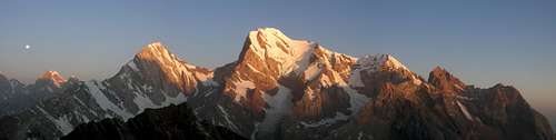 Alpenglow on Chimtarga (in the middle) as seen from the high camp on Zamok.
 On the upper northern slopes of Chimtarga, looking towards the summit.
 The south face of Chimtarga, as seen from the summit of Energia (5120 m).
 Chimtarga as seen from east.
 Climbing towards the Chimtarga pass (4750 m) below the SE face of Chimtarga.
 A panoramic view of the Chapdara valley near mountaineers' camp "Vertical-Alaudin".
 Route from the Big Alaudin Lake to the Mutnye Lakes.
 Camping at the Mutnye Lakes (looking south).
 Camp sites at the Mutnye Lakes with Chimtarga in the background (looking west).
 Approaching the summit of Chimtarga: a 180° panorama from S to N, looking west.
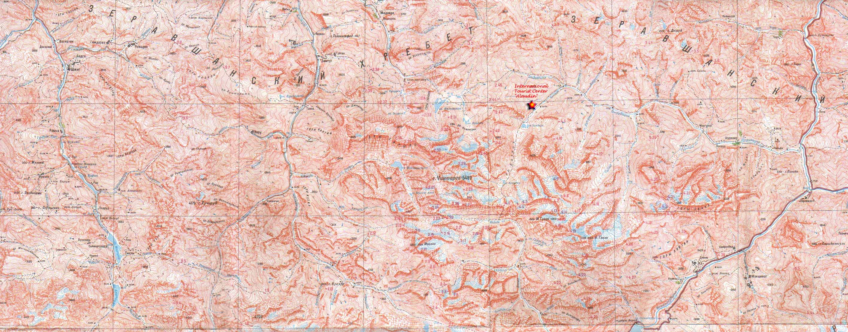
runout - Jul 31, 2019 12:46 am - Voted 8/10
information about the (normal) Mukhin route from Mirali passSnow/ice up to 45°. Loose rock section of ~40m (UIAA II-III). Some small to medium cams are nice to have. Fixed slings in place for abseil with 60m rope. (July 2019)