
|
|
Mountain/Rock |
|---|---|
|
|
45.96594°N / 10.45047°E |
|
|
Lombardia |
|
|
Hiking, Scrambling, Skiing |
|
|
Spring, Summer, Fall, Winter |
|
|
9045 ft / 2757 m |
|
|
Overview
Cima Laione 2757 m
Cima Laione 2757 m is one of the Southernmost peaks in the Adamello Group. It is located alongside the more famous Cornone di Blumone, nearby the border between the Adamello group and the Prealpi Lombarde.
Cima Laione rises to the NE of Lago della Vacca, at the intersection of three ridges: the North ridge, connecting it to Monte Listino, continuing as far as Re di Castello and dividing the Val di Leno (Val Daone) to the East from the Val Dois (val Camonica); the South ridge, continuation of the first, which descends on the Passo Blumone and continues with the Cornone di Blumone; the W-SW ridge, connecting it to the Cima Terre Fredde, passing through the Passo Laione and the Cima Galliner, which separates the lake from the Val Paghera di Ceto.
Getting There
Cima Laione is situated in the Brescia Province, Lombardy county. Can be reached from Milano: motorway to Bergamo-Seriate, then following to Tonale Pass until Breno and turning right to the Crocedomini Pass or from Brescia: follow to Bagolino and then turn left to Crocedomini Pass.
Road access
- from Val Sabbia: once you reach Lake Idro, continue along the lake, passing Anfo and just before Ponte Caffaro take the road on the left to Bagolino and Passo Croce Domini. Reached Bagolino, ignore the road to the left to Passo del Maniva and follow the signpost to Passo Croce Domini and Gaver (SP699). After the small village of Val Dorizzo enter the Gaver plain. The road turns decisively towards the West (left) and with some hairpin bends it climbs to the pastures where it's located the Malga Cadino della Banca 1799 m, a farm on the left of the road. You can park here or drive up the Val Cadino to the right on a dirt and bumpy road reaching a small parking lot under the Corna Bianca.
- from Val Camonica: after passing the detour to Boario Terme, proceed to take the road to the right to Passo Croce Domini. After passing Berzo Inferiore and Bienno, the road also passes Campolaro and Bazena, about 1 km before the pass. From here there is a path to the Refuge Tita Secchi (longer access). Alternatively reach the Passo di Croce Domini, from where the road then descends briefly and then climbs up to the Goletto del Cadino, after which it rapidly loses altitude to reach the grassy plateau of the Malga Cadino della Banca as in the previous point.
Approach walk to Rifugio Tita Secchi
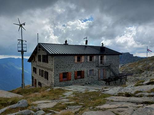
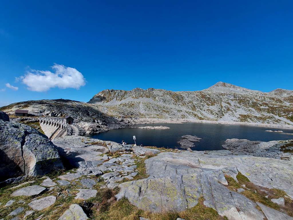
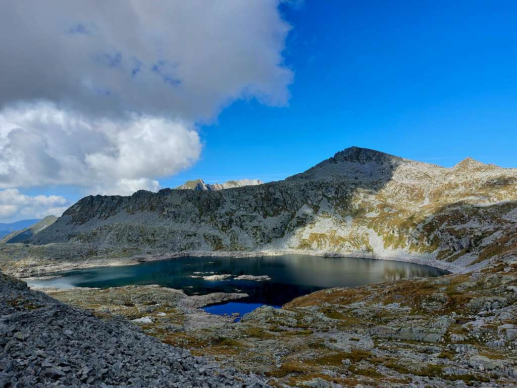
Whether you have decided to walk up on foot from the road near Malga Cadino della Banca or whether you have drive up on the rather bumpy white road, you will reach a small parking lot on the left below the Corna Bianca, a white limestone tower on the right of the mule track. From here walk up the path with a first stretch of fine sand in view of a small lake on the left below and then cross a slight slope between rhododendrons. On the right it branches off the “old” path 19, while the new path, paved with large plates, in a short time reaches a first saddle, where it converges the path 18, rising from the locality of Bazena. Continue on the path 1, which coincides with the first stage of the Alta Via dell’Adamello. After various zig zags the path reaches the Passo della Vacca at 2359 m, where there is a huge stone in the shape of a cow. Always continuing on trail n. 1 in about ten minutes downhill and then in a short ascent you will reach the beautiful Lago della Vacca with the former Rifugio Gabriele Rosa, now used as a winter bivouac, and just above the Rifugio Tita Secchi. The hut is situated in a fine position near the lake and it's overhung by the imposing Cornone di Blumone.
Cima Laione Normal Route
Summit quote: 2757 m
Difficulty: EE
Difference in level: 958 m from Malga Cadino della Banca, lower difference in level from the car park under the Corna Bianca
Starting point: Malga Cadino della Banca 1799 m or parking lot below Corna Bianca
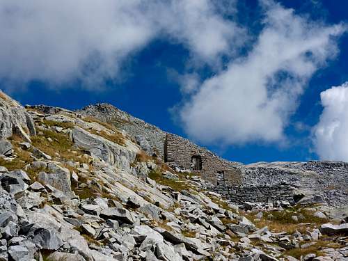
From Rifugio Tita Secchi 2357 m take the path to Passo Blumone on the left near the lake. The path crosses the stony ground that descends from the Passo Blumone, between Cima Laione on the left and Cornone di Blumone on the right. After the first stretch (3 consecutive hairpin bends) you pass another 4 more relaxed hairpin bends, before you find a junction to the left near a pole (path M. Antonioli, white-yellow). Follow the white and yellow signpost, across slopes strewn with boulders and outcropping rocks, up to the picturesque WWI citadel of the Alpini, with the remains of buildings on three floors, connected by stone stairways, still accessible.
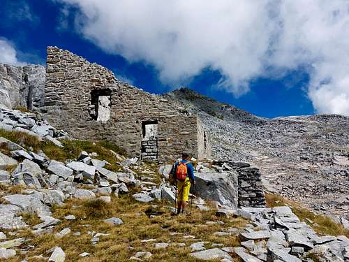
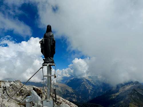
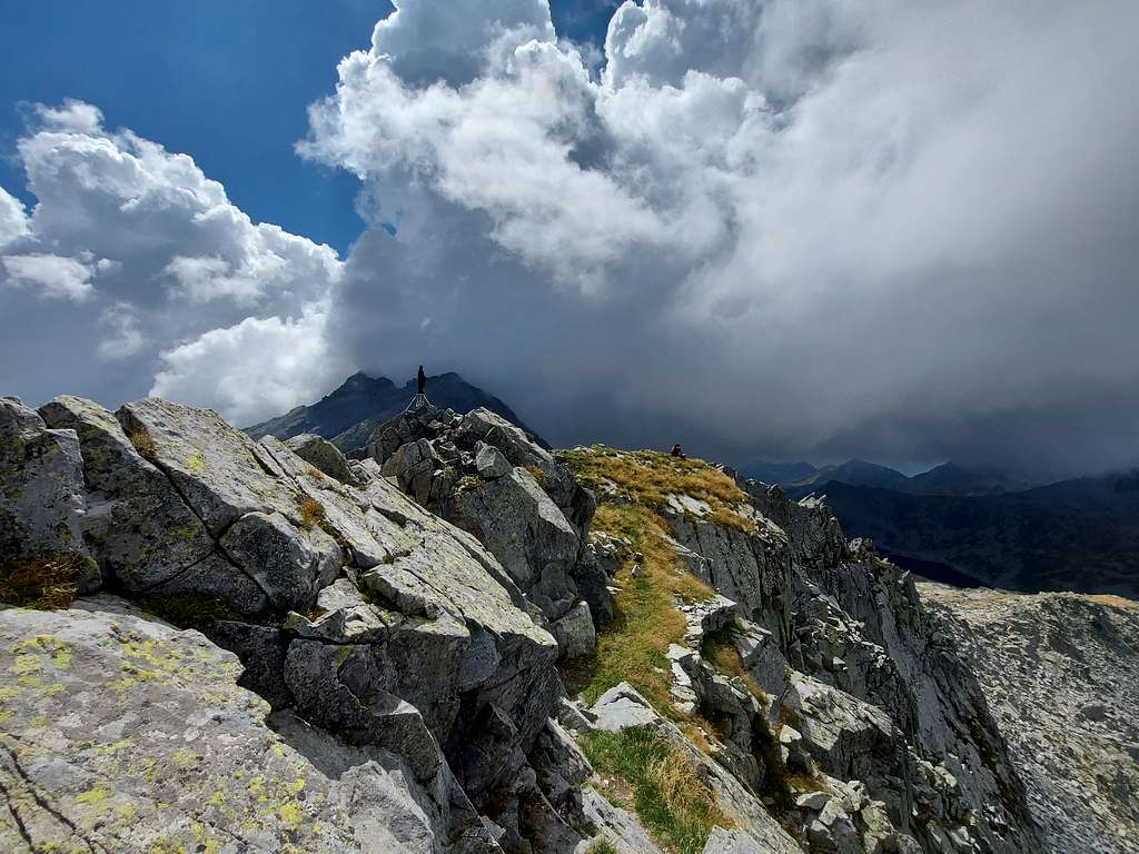
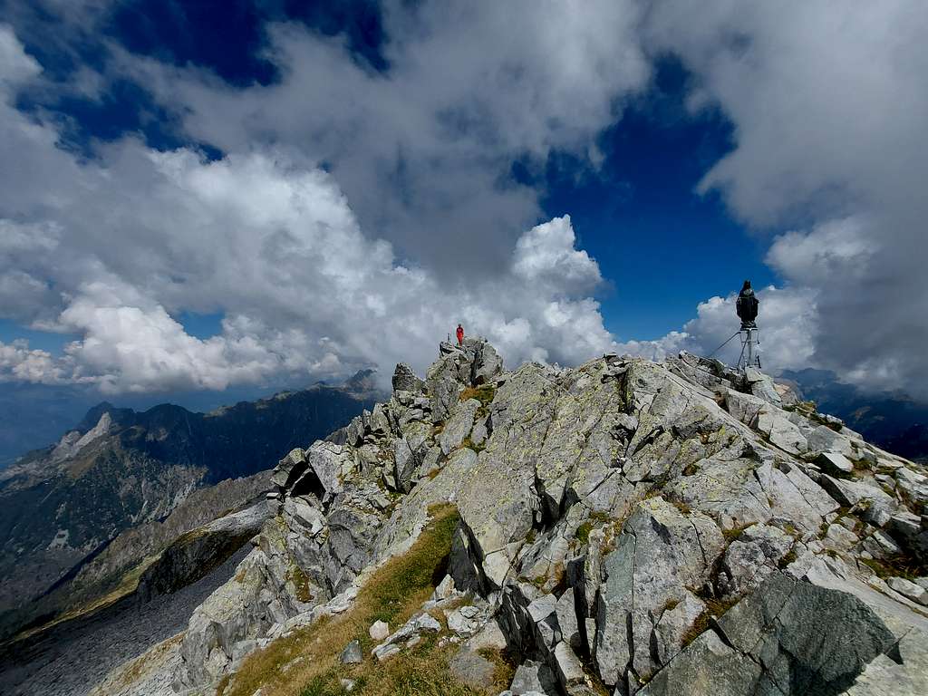
From here continue on the back of the ruins, initially following the white-yellow signpost. When this path turns left you meet on the right an old mule track without signposts but with some cairns, at times it disappears or becomes a trace but it's intuitive. Take this mule track and follow it to the right among grassy ground and fine granite rocks. Once under the summit, you reach the SW ridge then a stone cairn and in a few meters a fore-runner on the summit ridge where it stands the statue of the Madonnina del Laione. The highest point is a few meters ahead near a small cross. A nice ledge on the left leads to the real summit, where, in addition to the old base of the sacred statuette, a stylized flower that adorned her feet remains. The ledge is wide and easy, offering a single one meter passage where you use your hands for safety. Descend from the South ridge, along a nice military path with large cairns, to the ridge that leads to the Passo Blumone 2622 m. Shortly before the pass, we cross the path n 1 of the Adamello, which goes left towards the Listino and the ref Maria and Franco, while we follow it towards the right up to the pass. Going down towards the Lago della Vacca, we find the Antonioli crossroads, through which we passed, and thus we close the ring. At the parking lot following the path of the climb.
Red Tape
No fees no permits needed and no particular restriction. Cima di Laione is located inside the Parco dell'Adamello, which extends for 510 square kilometers on the left orographic side of Valle Camonica, in the North-eastern portion of the Province of Brescia (Lombardia). In the Trentino side of the Adamello group we find the Adamello-Brenta Natural Park, the largest protected area in Trentino, established in the year 1967.
Hiking grades of difficulty
T - Turistico (Tourist): Itineraries on wide, clear and well worn paths, sometimes on mule tracks or gravel roads. The routes are never exposed, don't give any orientation problems and don't exceed 2500 meters of altitude. Suitable also for children
E - Escursionisti (Hikers): Itineraries on marked trails, even narrow and with possible steep and impervious sections. They are never exposed and don't give any orientation problems. They can tread different kinds of ground, such as forests, gravel, meadows, pastures, easy rocks, etc.). They form the majority of the trails that wind up in the mountains and require a certain habit to walk; you need equipment suitable for the altitude and resistant footwear with soles suitable for rough terrain
EE - Escursionisti Esperti (Experienced Hikers): Itineraries for hikers with experience and good knowledge of the mountain. Some of these paths may have exposed sections, however brief, which require firm foot and no dizziness. They require the ability to adapt to particular terrain, such as steep grassy slopes or stretches of rocks with difficulties that can reach the 1st degree of the UIAA scale. They can also reach high altitudes (3000 m or more). Sometimes they may include unmarked sections, requiring a good sense of orientation. Snow slopes are possible, however which can be overcome without specific mountaineering gear (rope, harness, crampons, ice-axe)
EEA - Escursionisti Esperti con Attrezzatura (Experienced Hikers with equipment - The same as EE, in addition these routes require the use of via ferrata equipment (lanyards, harness, carabiners, heat sink, helmet). This kind of itineraries range from the trails with short easy and not much exposed sections, previously equipped with fixed ropes and iron pegs, to the true and more difficult Via Ferratas climbing on rocky walls or on aerial ridges and ledges, previously equipped with long stretches of iron ropes, iron steps, ladders without which proceeding would constitute a real climbing. It is necessary to know how to use the technical equipment and have a certain habit of exposure and mountaineering terrains.
When to Climb
Hiking: best time is from June to October. In winter you need ice and snow gear.
Ski-mountaineering: from February to April-May
Hut
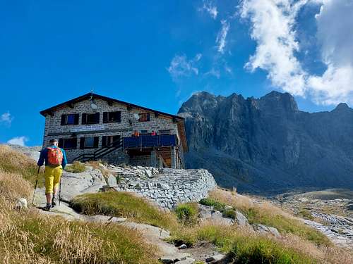
Rifugio Tita Secchi 2357 m (al Lago della Vacca)
Phone: 00390365903001 - 0039337441650
The Rifugio Gabriele Rosa, located in the immediate vicinity, is not managed and it may be useful in winter.
Bibliography
"Adamello" Vol. I - Pericle Sacchi - Collana Guide dei Monti d'Italia CAI-TCI
Meteo forecast
Meteo ARPA Lombardia
Meteo Trentino