
-
 5437 Hits
-
 88.61% Score
-
 27 Votes
|
|
Mountain/Rock |
|---|---|
|
|
46.20612°N / 10.51646°E |
|
|
Lombardia |
|
|
Mountaineering |
|
|
Summer |
|
|
10581 ft / 3225 m |
|
|
Overview
Geographical classification: Alps - Eastern part > Rhaetian Alps > Adamello Group > Cima Calotta
Cima Calotta m 3225
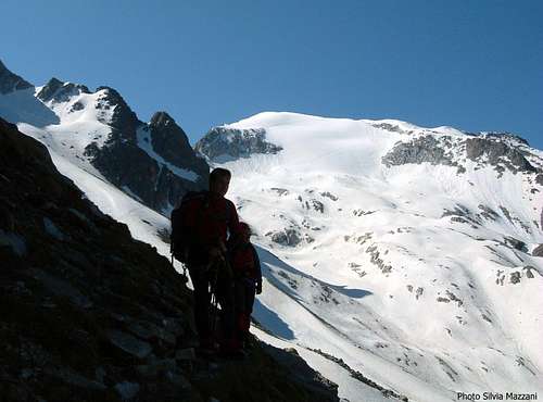
Cima Calotta is a mighty ice-capped mountain, well visible from the upper Val Camonica, belonging to the Veneròcolo Subgroup, a sub-range situated within the Adamello Group, amongst the cols of Tonale, Presena and Garibaldi. The peak is located on the ridge running between Cima di Salimmo and Monte dei Frati and it’s delimitated by Bocchetta della Calotta and Bocchetta della Val dei Frati. The Eastern side dominates the Pisgana Glacier, while the Western side projects a long rocky ridge towards the Avio Lake. Running on the Northern side of Cima Calotta there is a classic and easy route, the normal one to reach the summit, advisable also in reason of the wide and interesting view over Adamello and Ortles-Cevedale Groups. This route is one of the most popular ascent of Adamello Group, involving a varied climb inside a wild and spectacular environment; it can be approached from Valle Camonica, spending the night at Petitpierre – Corno d’Aola shelter or putting a tent on the Pozzuolo basin.
Cima Calotta è un'imponente montagna ricoperta di neve e ghiaccio, ben visibile dall'alta Val Camonica, appartenente al Sottogruppo del Veneròcolo, Gruppo dell'Adamello, e situata tra il Passo del Tonale, il Passo Presena e il Passo Garibaldi. La vetta si trova sul crinale compreso tra Cima di Salimmo e Monte dei Frati ed è delimitata dalla Bocchetta della Calotta e dalla Bocchetta della Val dei Frati. Il versante orientale domina il ghiacciaio Pisgana, mentre il versante occidentale proietta una lunga dorsale rocciosa verso il lago Avio. Lungo il versante nord della Cima Calotta è situato un bell'itinerario classico, si tratta della Via Normale, consigliabile anche per l'ampio ed interessante panorama sui gruppi dell'Adamello e dell'Ortles-Cevedale. Questo percorso è uno dei più frequentati del Gruppo Adamello e comporta una salita varia in un ambiente selvaggio e spettacolare. L'avvicinamento può avvenire dalla Valle Camonica, pernottando al rifugio Petitpierre - Corno d'Aola o mettendo una tenda nella conca di Pozzuolo.
Getting There
Road Approach
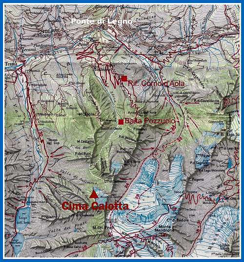
The starting point is the village of Ponte di Legno m 1258 in the upper part of Val Camonica, the Western (from Lovere to Edolo) and Northern (from Edolo to Tonale pass) border of the Adamello group.
Getting to Val Camonica
- From Brescia or Bergamo; the roads coming from Brescia and Bergamo combine near Darfo in to the only state road SS 42 of Tonale and Mendola, which is running near the western limits of the Adamello Natural Park, crossing the villages of Boario Terme, Breno, Cimbergo, Paspardo, Cedègolo, Edolo, Temù and getting to the important resort of Ponte di Legno m. 1258 (66 km from Darfo).

|

|
Getting to Refuge Petitpierre aka Refuge Corno d’Aola 1920 m
By car - Just before entering the village leave the main road and take on the right an unsurfaced road to Valbione and the Petitpierre Hut, starting nearby a chair-lift and reaching the shelter after 7,5 km
By the Valbione – Corno d’Aola chair-lift
By foot – 2 hours from the chair-lift lower station

Another possibility is to put a tent on the Baita di Pozzuolo meadows
History
First summiters: A. Gstirner, Schumann and Karl Schulz with F. Caola and G. Collini 1892, July, 27th
Cima Calotta Normal Route
Cima Calotta North Flank Normal Route report
Summit altitude: m 3225
Difficulty: Alpine F
Difference in level: 1300 m from Rif. Petitpierre al Corno d’Aola
Exposure: North
First ascent: B. Cavalieri – D. Ferrari – B. Bettoni 1895, September 2nd
Hut: Rifugio Petitpierre al Corno d’Aola m 1920
Starting point: Ponte di Legno m 1258, upper Valle Camonica
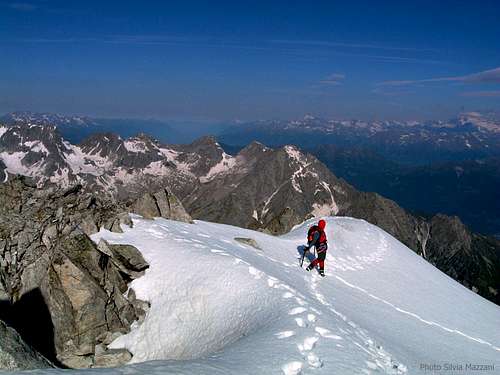
A very interesting and panoramic route inside a wild environment, following at first a good path, then the Northern ice slope and the summit ridge

|

|
From the hut follow a well worn path (CAI n° 40) to the charming basin of Baita Pozzuolo m. 2006, cross the basin and reach a fork at 2475 meters. Leave the track on the left (leading towards Cima di Salimmo) and continue along the path n. 40, getting the narrow and rocky saddle named Bocchetta dei Buoi m. 2475. Descent on the opposite side and skirt the slopes on the left side, heading toward the obvious Northern ice-slopes of the peak and gaining the bottom of the face. Rope up and climb the regular 45° ice-slope, reaching the summit ridge. Turn to left and follow the beautiful and panoramic ridge, getting to the summit.
Descent: reversing the same route

|

|

|
Essential gear
Rope, axe and crampons.
Hut
- Rif. Petitpierre al Corno d’Aola m 1920
Red Tape

No fees no permits needed and no particular restriction in climbing and hiking. Cima Calotta is located within Parco dell'Adamello, which extends for 510 square kilometers on the left orographic side of Valle Camonica, in the north-eastern portion of the Province of Brescia. Camping is not allowed and fires are strictly forbidden.
When to climb
Best season goes from the end of June to the end of September.

|

|
Meteo
Guidebooks and maps

Guidebooks
"Adamello" volume II by Pericle Sacchi, Guida dei Monti d’Italia CAI – Touring Club - "Adamello" by Piermario Soregaroli
Maps
- Tabacco "Adamello-Presanella" 1:25000 - Kompass n. 71 Adamello-Presanella 1:50000