
-
 38836 Hits
-
 89.21% Score
-
 29 Votes
|
|
Mountain/Rock |
|---|---|
|
|
37.83741°N / 83.6204°W |
|
|
Hiking |
|
|
Spring |
|
|
1092 ft / 333 m |
|
|
Kentucky's Summit Slot Canyon
Cloud Splitter is a fun and unique summit tucked within Kentucky’s Red River Gorge. If you do not know this area, you should - it boasts dozens of major arches, sandstone viewpoints, premier rock climbing routes and primeval trails. While researching a trip last year, I came across references to Cloud Splitter Arch, and put it on my short list of hiking/scrambling objectives.
That trip, I could not even find it – as the twisting trails disoriented my sense of direction and the forest canopy hid the topography from my sight, I ended up trying to climb the wrong mountain (there is a parable there somewhere).
This year, I found it, and it is much more than an arch. It is a uniquely fun combination of scramble route to a summit dome that incudes its own small resident 'slot canyon' – a crack which in turn becomes a cave that ends in a beautiful viewing window 'balcony' on the side of the summit. This is no alpine experience as far as elevation, but it is something unique and fun and should be included in any trip to this area. However fun, it should not underestimated either. There are drop-offs and dangers too - take caution, especially in the canyon.
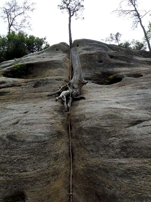
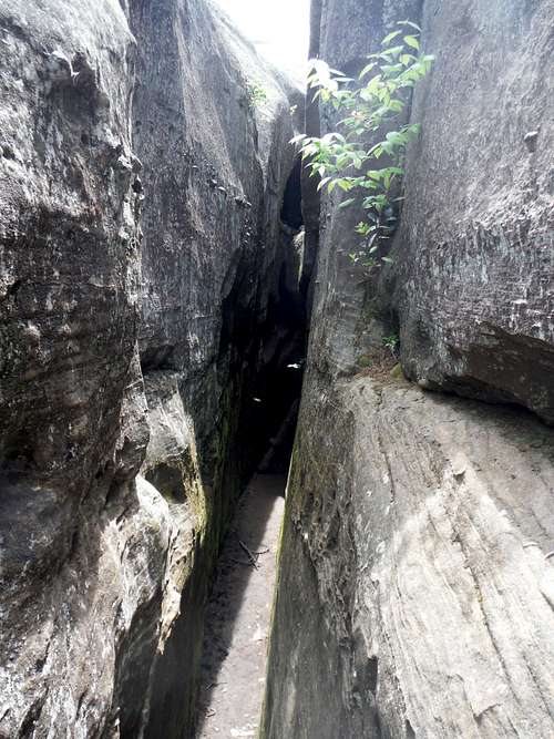
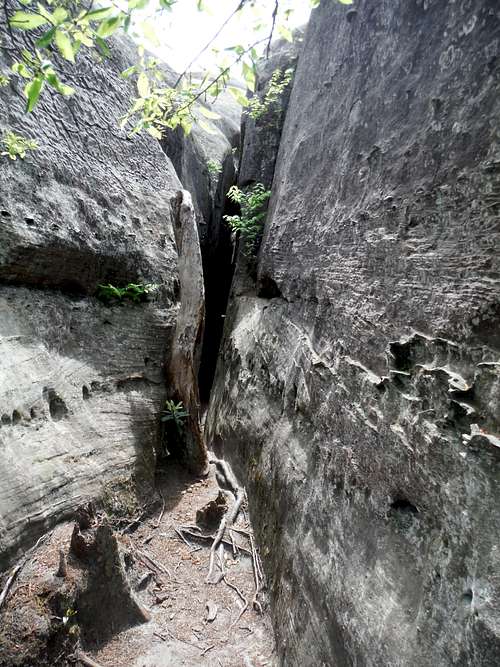 Entrance to Summit Slot Canyon
I thought about not posting this, it is the kind of thing that is precious and you do not want wrecked from over-popularity. But do any research on the Gorge on the internet and you will run across references to Cloud Splitter, some of which outline erosion producing ‘short cuts’ from the Route 715 rather than using the Sheltowee Trace trail. I think summitpost users will appreciate this spot and respect it.
Getting There
To get to the Red River Gorge Geological Area, get off the Bert Combs Mountain Parkway onto Route 15 at Slade KY (Exit 33). Take Route 15 west several miles to the far eastern end of the park and turn left into Route 715. Stay on 715, descending the narrow parkway to the Red River itself (when in doubt stay on paved road and go down). After passing the Gladie Cultural Center on your left , cross over the bridge of Gladie Creek and park at the Bison Way trailhead. There is only room for about 6 or 7 cars so come early. Alternatively, park at the Gladie center and walk to the trailhead.
This is start of a wonderfully scenic route to the spur trail to the summit.
Route
I intentionally recommend the route below to give one a taste of the best of the Red River Gorge and to avoid temptation to use any short cut trails.
Begin by taking the forested Bison Way trail .75 miles to its intersection with the Sheltowee trace, marked with a white diamond and sometimes a turtle. Go left at the junction, taking the trail northwest.
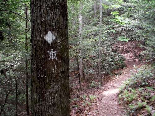 Sheltowee Trace
In general the Sheltowee Trace trail zigs back and forth into and out of the small canyons formed by the arms of the forested sandstone outcroppings that make up the Gorge area. But there is one detour not too far along the Trace you will not want to pass up. Quite quickly once you get going northwest along the trace you will pass two large social trails on the right. If you ignore the first trail (marked with a sign to stay off) and take the second, you will enjoy a wonderful side trip from the Sheltowee Trace. The trail goes up up and through the forest, then climbs via rocks and rolling sandstone, and finally the ‘Indian Staircase’, a series of moqui steps up the sandstone nose of the rock above to the top of the ridge. The steps are something easy for most of the SP community (mild class 3) but others may need some coaching, as there is some exposure.
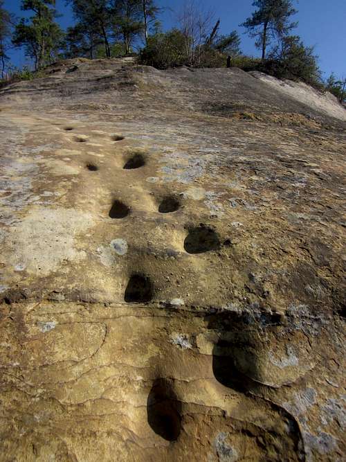 Indian Staircase - Going Up
 Looking Down the Indian Staircase
After some slickrock type scrambling and more steps, you reach the top. The ridge edges around the small canyon boast great views, a locally famous frog head, and a very large rock overhang at the head of the canyon, complete with stream and waterfall.
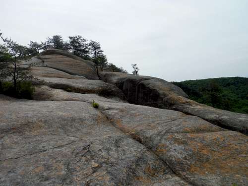
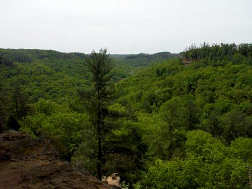
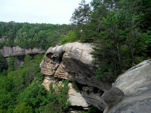 Red River Gorge Scenery
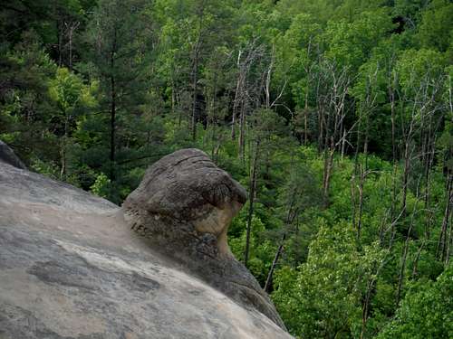 The Frog Head
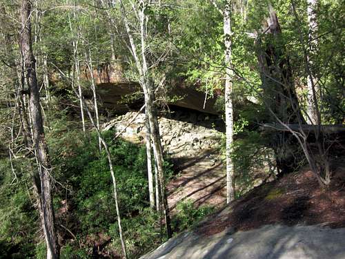 Council Chamber
The presence of the large ‘council chamber’ led to the conclusion that archaic Native Americans (who did use the chamber) had fashioned the ‘staircase’. The latest theory, though, is that the steps were fashioned by pre-Civil War era miners hunting saltpeter.
Take the trails on the ridge up all the way around a circuit of the small canyon,which will return you to the Sheltowee Trace trail about a quarter mile or more from where you left it. The junction is easy to miss, as the left is well marked as Sheltowee Trace but the right (whereyou want to go) is not. On my first time on this route I missed the right turn and went back along the Trace into the lower interior of the canyon that I had just circumnavigated from above.
A Nice Map of Indian Staircase Route
Cloud Splitter is not marked on the above map – but can be located as the summit just northwest of the ‘Route 715’ emblem.
Continuing down the Trace trail, you will work your way in and out of the next major drainage, wondering when the spur trail on the right you are looking for will appear. You have to work around Cloud Splitter (invisible due to the foliage) until you are west of the ridge that it sits upon. The spur trail on the right occurs next to the most unimpressive steam in Red River Gorge, a tiny flow on a muddy streak across the trail. But this is where you will head up to Cloud Splitter.
I never found this spot on a previous attempt. This was the first time I had to rely on GPS coordinates, so I will include them here:
N 37 50 271
W 83 37 342
Headup the unmarked spur trail, through the vegetation, and scrambling up small bands of sandstone.
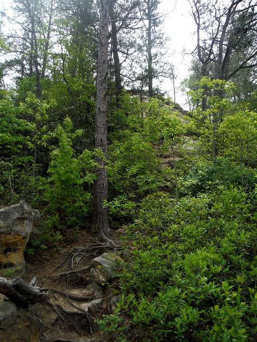 Spur Route to Cloud Splitter
After a while you will reach the orangish head wall of Cloud Splitter. In May 2015 there was a rope available to getup the central crack in the Class 4 slickrock wall (I found the rope convenient to use but in retrospect I should not have relied on it). But on the right there is a root rich gully that gets you up easily.
 Cloud Splitter Summit Headwall
Here you can make a choice: Summit (Ahead of You) or Slot Canyon/Cave/Arch (To the right).
 Cloud Splitter Summit..And Slot Canyon
Summit
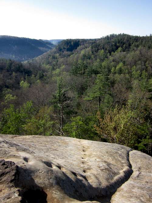
Travel the wonderful slickrock to the top of Cloud Splitter. Though the very top has a small patch of trees every other part is bare rock with captivating views of the gorge area.
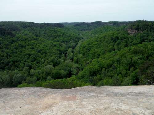 View from Cloud Splitter over Red River Gorge
The ‘Split’ in Cloud Splitter (the huge crack that is the home of the slot canyon described below) is apparent from most everywhere on the summit .
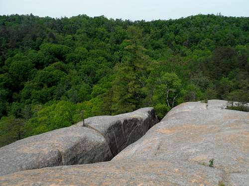 The Split in Cloud Splitter
Slot Canyon/Arch/Window
While this part of the summit is called Cloud Splitter Arch, it is really a combination short but sweet slot canyon, cave and balcony window. In many respects it is a much stiffer challenge than the summit. I knew I could get up the summit – I had no idea if I could get through the slot.
It takes only a little exploring to find the entrance to the ‘Split’. It immediately intimidates with a tight squeeze...
Entrance to Summit Slot Canyon
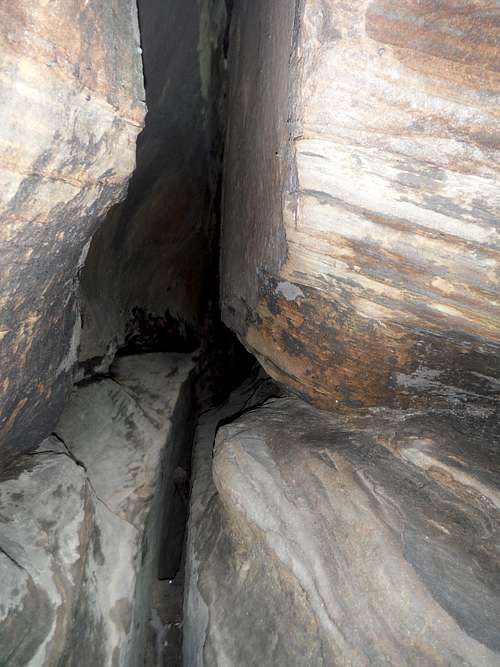
that leads one to the crux - a crack passage that starts about about 7 feet above ground.
 Cloud Splitter: The Slot Begins - About 7 feet Up
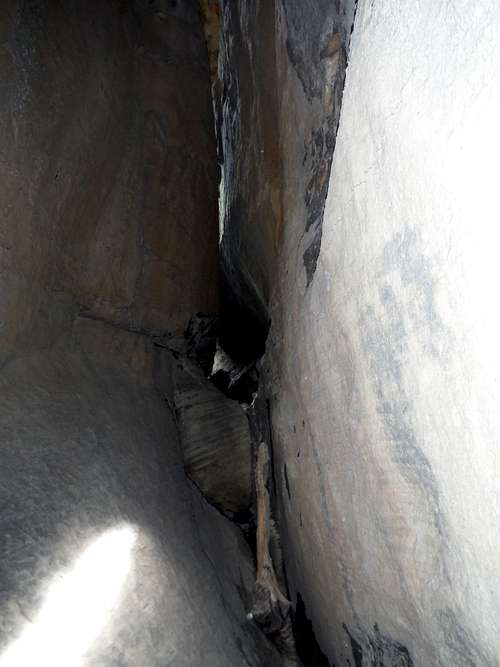
... I was grateful for the log helper (my chimneying skills maybe would not have sufficed) but it doesn’t make getting up an easy experience. Maneuvering up into the ‘thick’ part of the crack (which is just one person width wide and still open on the bottom) was not easy on my 55 year old physique. Did I mention you have to crawl or slither through this?
 In the Crux of Cloud Splitter's Slot
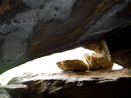
Travel through the crack, dropping down into a cave that leads to the window.
 Slot Drops into Cave
 Approaching Cloud Splitter's Window
The window is a stunning rock balcony over the Red River Gorge.
 First Views from Cloud Splitter Window
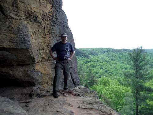 Edge of Cloud Splitter Window
The view may be nearly the same from the summit, but it felt a bit more special.
Getting back through the crack (which seemed to get smaller on the way back) was just as hard.
To Finish this route, go back to the Sheltowee Trace, turn right and take the trail to its intersection with Route 715. Check out the swing bridge over the Red River which is very close by, but I am afraid you will have to walk the road back to Bison Way trail head or retrace your route 5 miles back on the Sheltowee Trace.
Red Tape
No Fees except if camping.
When to Climb
Summer is very humid – Spring or Fall much better. Can be popular trail on weekends unless you go early.
External Links
Area Info: Red River Gorge
Maps: Here