
|
|
Mountain/Rock |
|---|---|
|
|
46.15450°N / 115.457°W |
|
|
Idaho |
|
|
Hiking |
|
|
Summer, Fall |
|
|
6929 ft / 2112 m |
|
|
Overview
 Coolwater Ridge from the 317 road
 Coolwater Ridge Lookout
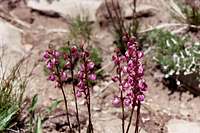 Pink Coiled-beaked Louswort
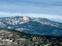 Distant view from the Crags
 Rocky Mt. Aster
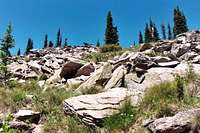 Subalpine and talus
 Pale Yellow Penstemon
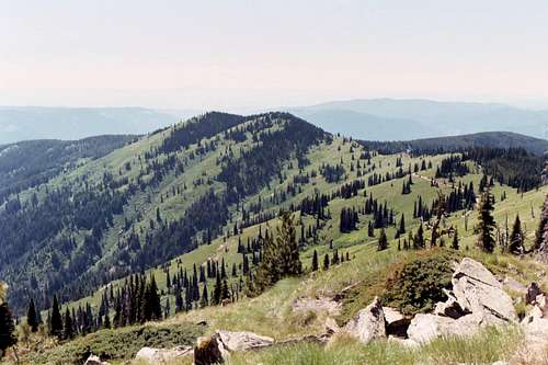
 West Ridge
Coolwater Ridge is the western-most high point of the divide separating the Selway and Lochsa basins. It is not actually in the high crags, but connected as a western extension of the divide. It is still a noteworthy summit due to its dramatic vertical rise of nearly 5,500 feet above the Selway/Lochsa confluence, relatively substantial prominence of 1,129 feet, and it supports three nice mountain lakes and a couple ponds in small north side basins. It also supports one of the very few active lookouts still in operation. The broad south aspect holds snow well into the summer and offers a beautiful and dominating view for miles onto the Camas Prairie to the west.
The mountain offers a significant hike from trails in the canyon bottoms on both the north and south sides. These all offer more than a mile vertical rise. Or a road can be driven almost to the top. This is not as easy as it sounds because the road is one of the most rugged anywhere and is virtually undriveable to many vehicles and not for the faint of heart. The crest of the ridge runs east-west for about seven miles, the bulk of it sitting above 6,000 feet. It is formed of crumbly granite and quartz derived material. The north side is forested with subalpine fir, but much of this is mostly brush after huge fires in the early 1900s. The south side is a beautiful parkland of open subalpine fir scattered across lovely verdant slopes of subalpine grasses, sedges and beargrass. The lower slopes are covered by the inland coastal refugia rainforest famous in the Clearwater Basin and some less common subalpine coastal disjunct are also found on the upper slopes. There are also endemic species. In the fall patches of huckleberry, mountain ash and other shrubs turn color for a spectacular display.
The views are particularly spectacular due to the mountains relative elevation and positioning. To the west it is possible to look far beyond the Camas Prairie into the big canyon country of Oregon and Washington. To the north it is possible to see into the northern Clearwater basin and possibly a few points within the St. Joe. South the higher summits on the South Fork Clearwater/Salmon divide can clearly be seen. When the air is clear peaks south of the Salmon are visible as are the Seven Devils and possibly beyond. The eastern view is the best with the high central Selway Crags in the foreground and the higher expanse of the Montana Bitterroots far beyond. All these mountains fall into exceptionally deep and dark canyons of the Lochsa and Selway rivers.
The mountain gets a fair number visitors primarily because it provides the main west entrance to the main Selway Crags. Also the lookout is a destination for some and use during the fall is high during hunting season. Wearing orange and traveling in groups is advised during that time. Use is much lighter during mid summer, but the flies and mosquitoes can be hellacious, especially near the lakes. The area also supports mountain goats, which can be seen on the rugged north slopes.
Getting There
 Andy's Hump and Road 317
Ways to obtain this summit range from easy to difficult. From the lowest elevation trailheads in the Lochsa and Selway canyons, an ascent of over a mile is needed to reach the summit. These are long, generally strenuous routes that are generally used by outfitters during hunting season. The Coolwater Ridge Road (Forest Service Road 371) allows one to drive almost to the top.
Coolwater Ridge Road (317)
The easiest way of course is to take the road from Lowell. The Coolwater Ridge Road is accessed off the Selway River Road less than a mile upstream from Lowell and Highway 12. It is narrow and twisty, but in fair shape up to about the Andy’s Hump vicinity where it breaks out into the open slope parklands of Coolwater Mountain. Here the road gets very rocky with some steep pitches. It is not possible or safe to drive this without high clearance and preferably 4WD. It is not possible to get all the way to the top, without actually driving on a trail, but rough driving can get you very close. It may be more desirable to park at the saddle on the east side of Andy’s Hump and either walk the road to the summit or walk the ridgeline. Either way will require about a mile and a half of hiking.
Lochsa Trails (north side)
Coolwater Ridge can be reached from Highway 12 along the Lochsa River via the following trails:
|
Selway Trailheads (south side)
There are also trails from the Selway bottoms that ascend to Coolwater Ridge or connecting points along the 317 road. These are as follows:
|
Red Tape
None. However, if hiking east from Coolwater Ridge into the Selway Bitterroot Wilderness be aware of wilderness regulations.Camping
 Coolwater Lake
 Fire Lake
There is not a lot of camping opportunity directly on the mountain. All the lakes can be reached by short cross-country hikes. There is also a good dispersed site along the road near Andy’s Hump, where the main body of the ridge starts. Otherwise there are several developed campgrounds in the lower Selway and Lochsa river corridors.
When To Climb
The area receives huge amounts of snow that may linger on the north slopes into August some years. However, the open south face loses its snow by mid-June most years. Late summer or early fall would be best, especially after the bugs have died off. However, trips later in the year have the increased likelihood of having the air heavy with smoke from free burning wilderness fires or sharing the mountain with hunters.Mountain Conditions and Information
 Coolwater Ridge from the east
Go to the mountain prepared for variable conditions. With over a mile of vertical lift from the canyons of the Lochsa and Selway upper ridgeline, mountain temperatures and weather conditions can vary dramatically. Many years the trails and slopes are open from snow by mid-June, but in heavy snow years some high ground, especially the north slopes may not lose snow until fall.
Contact the Moose Creek Ranger District of the Nez Perce National Forest for information and current conditions.
Moose Creek Ranger District/Fenn Ranger Station
831 Selway Road
Kooskia, ID 83539
(208) 926-4258
Office hours
Mon-Fri, 7:30 - 4:00
The north side of the ridge is on the Clearwater National Forest, Lochsa Ranger District.
Lochsa Ranger District/Kooskia Ranger Station
Route 1 Box 398
Kooskia, ID 83539
(208) 926-4274
NOAA Forecast