|
|
Mountain/Rock |
|---|---|
|
|
46.15750°N / 115.195°W |
|
|
Idaho |
|
|
Hiking, Mixed, Scrambling |
|
|
Summer, Fall |
|
|
7515 ft / 2291 m |
|
|
Overview
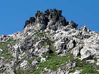
 The southeast aspect of Peak 7,515.
Peak 7,515 is an unnamed ridge point between the upper Canteen Basin and Three Links Creek in the small local range of the Selway Bitterroots known as the Selway Crags or simply The Crags. These highly sculpted jumbles and precipices of Idaho Batholith granite occupy the divide between the Lochsa and Selway canyons in the Clearwater Basin of north central Idaho. Peak 7,515 is formed by a precipitous, yet relatively small protrusion of dark granite on the ridge line just to the northwest of Legend Lake. The ridge runs perpendicular into another ridge that forms the south side of the South Three Links Basin. A slightly higher point lies to the west of this junction, but it has low prominence due to its close association with higher points. Peak 7,515 rises nearly 6,000 feet over the lush warm cedar forests of the Selway River in the western end of the extensive Selway Bitterroot Mountains. The immediate rise over the Canteen Basin at its west foot is nearly 1,500 feet and it rises approximately 1,200 feet above the wet meadows at its east foot and over 4,500 feet from the confluence of Three Links Creek and the West Fork of Three Links Creek. It has approximately 514 feet of prominence.
The high point forms a pyramid with the west side sloping up gradually before rising abruptly to form the outcrop summit. The east side is much more spectacular, forming a 300 foot wall that drops off onto some benches breaking above Legend Lake. The north side drops to an open ridge line that proceeds north before dropping 1,200 feet into a series of cliffs and broken slopes to the lower South Three Links Lake.
 South side
 West side
The mountain probably gets few visitors though its probably busier than most points in the Selway Crags. This is because Legend Lake is one of the most accessible points from the Big Fog Trailhead, which is overall the best entrance to the Crags. Also one of the main routes into Fenn Mountain and the central crags is over this ridge from the Trailhead. How many people actually ascend the summit is uncertain, but since it’s a relatively small outcrop above the general ridge, its assumed that many make the stop. There is no summit register to answer this question.
Getting There
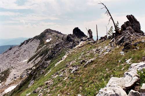 The Ridge Route
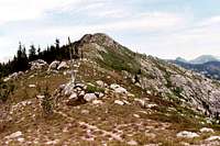 Leaving the trail
 Upper east side
 Ridge north of the trail
 Trail to Legend
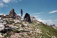 Summit in sight
 East side of ridge
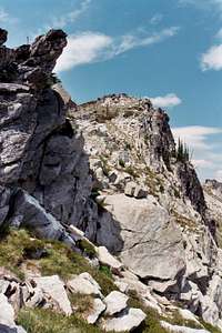 Almost there
 Heading to Legend
To reach the Big Fog trailhead, travel up the Selway River from Highway 12 at Lowell almost to Selway Falls. This is about 18 miles. The first several miles are paved, but most of the road is gravel. Some places are narrow and traffic can be heavy at times so watch the corners. Just before Selway Falls, take a left up the Fog Mountain road (Forest Service road 319). This road is well signed. From the Selway River the trailhead at road’s end is thirteen miles. The first half of this road is narrow, but in fair condition. The second half of the road gets progressively rough with large jutted rocks and seasonal streamlets breaking up the surface. A high clearance vehicle is advisable. The thirteen miles likely will take over an hour to reach the trailhead.
Once at the trailhead take the 343 trail to the east. This trail climbs fairly steeply before leveling off on the ridge and giving tremendous views of the Canteen Creek basin and the central Crags beyond. Soon the trail drops into a saddle before rising up the broad summit dome of Big Fog Mountain. Just before the top the trail will split with 343 going east and 363 continuing over the summit and the ridge beyond. Big Fog Mountain is reached after hiking only about two miles from the trailhead. Almost immediately Trail 363 will disappear on the broad ridge. Continue hiking through the open stunted subalpine forest until the broad ridge narrows and the trail reforms. From here one can continue on the trail down the east side, eventually reaching Legend Lake where good camping can be found. Then the ridge can be climbed to reach the summit. Or instead of dropping down off the east side of the ridge, it is easy to continue cross country along the ridge top to the high point. If staying on the ridge, it is easier to keep on the west side. It’s a little over two miles from Big Fog Mountain to Peak 7,515.
From the Big Fog trailhead it is also possible to hike the six miles on Trail 31 to Cove Lakes for a base camp. Then the ridge above the lakes can be ascended, then a nice ridge hike north, then east around the head of the Canteen Basin will reach this point after two to three miles depending on the route. There are other routes into this area from Highway 12 to the north and the Coolwater Ridge trailhead to the west. However, these are much further away and make the approach a multiple day affair. Consult local maps and Forest Service offices before confirming desired routes. Keep in mind that many trails in the area do not actually exist on the ground and cross country travel in this terrain can be difficult.
 Lower east side route via Legend Lake
Red Tape
None, other than standard wilderness regulations.Camping
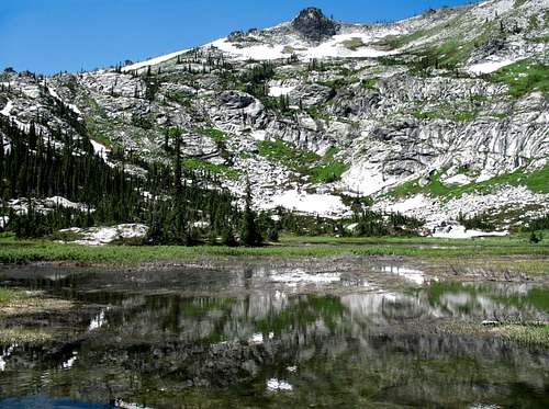
 Legend Lake
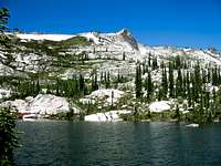 Legend Lake
 Legend Lake
The most logical and used camping spot to climb this ridge high point would be Legend Lake. It gets a fair amount of use and company can be expected at least on the weekends. Other than that there is no commonly used camping spot simply because its pretty close to the trailhead. The trailhead itself offers pretty good camping with a clean modern outhouse, but no water. Big Fog Lake also has some camping spots, but its not very far in. If camping there is an option, then proceeding on to Legend Lake makes more sense.
Occasionally people will start on the 31 trail, but then peel off in the Canteen Creek basin and camp at Canteen Meadows, which is in the bottom of the headwaters. Have a good topo map and be prepared for some potentially difficult cross country hiking. This meadow is at the immediate base of Peak 7,515 and can serve as a good base camp to the central high crags. Its not as easy to reach as some other prospects and requires some extra climbing to get out of the bottom before proceeding to anything, but
 Big Fog Lake
There are 11 campgrounds and several good dispersed sites along the Selway River road between Highway 12 and Selway Falls for those arriving late who don’t want to navigate the 319 road or arrive at the trailhead in the dark. For those coming in by the Coolwater route, a good dispersed site is along the road near Andy’s Hump. Driving the last few miles of that road in the dark may not be advisable either.
When To Climb
The area receives huge amounts of snow and hiking to the summit before late July may be difficult some years. Late summer or early fall would be best, especially after the bugs have died off. However, trips later in the year have the increased likelihood of having the air heavy with smoke from free burning wilderness fires.Mountain Conditions and Information
Go to the mountain prepared for variable conditions. With over a mile of vertical lift from the canyons of the Lochsa and Selway basins to the top of the Crags, mountain temperatures and weather conditions can vary dramatically. Many years the trails and slopes are open from snow by mid-July, but in heavy snow years some high ground may not lose snow until fall or not at all.
Contact the Moose Creek Ranger District of the Nez Perce National Forest for information and current conditions.
Moose Creek Ranger District/Fenn Ranger Station
831 Selway Road
Kooskia, ID 83539
(208) 926-4258
Office hours
Mon-Fri, 7:30 - 4:00
The north side of the Lochsa/Selway divide is on the Clearwater National Forest, Lochsa Ranger District.
Lochsa Ranger District/Kooskia Ranger Station
Route 1 Box 398
Kooskia, ID 83539
(208) 926-4274
NOAA Forecast