
-
 11333 Hits
-
 86.37% Score
-
 22 Votes
|
|
Mountain/Rock |
|---|---|
|
|
34.31890°N / 117.7874°W |
|
|
Los Angeles |
|
|
Hiking |
|
|
Spring, Summer, Fall, Winter |
|
|
7499 ft / 2286 m |
|
|
Overview: A Real Gem
This peak is magnificently situated at the southern end of a ridge bearing the same name. The ridge runs southeast from Mt. Hawkins (8,850’). The peak Copter Ridge is the distinct high point about 2 miles from Hawkins with a 1,300 foot elevation drop. It is approximately half-way between Ross Mountain (7,402’) to its northeast, and South Mt. Hawkins (7,783’) to its southwest. So the peak is poised for views, especially of the Sheep Mountain Wilderness Area. To the southeast is Iron Mountain #1 (8,007’) with a fabulous view of the San Antonio Ridge sweeping left to Mt. Baldy (10,064’).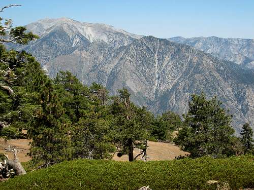
Iron Mtn.#1 (8007') with San Antonio Ridge sweeping left to Mt. Baldy (10,064'). Seen from summit of Copter Ridge 7.7.07.
The chasm of Iron Fork to the east separates Copter Ridge from the ridge that plummets 2,000 feet from Mt. Baden-Powell to Ross Mountain. To the west, Hawkins ridge, anchored by Middle Hawkins (8,505’) and South Hawkins, runs roughly parallel to Copter Ridge. Directly south is Rattlesnake Peak (5,826’).
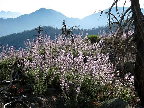
Apart from views, the other attractive feature of this peak is that, without exaggeration, the route down the ridge is one of the most enjoyable to be found anywhere. The ridge is adorned with an open pine forest with virtually no brush.

Summit of Copter Ridge seen looking south along ridge

Looking north along Copter Ridge 7.7.07
The name Copter Ridge was apparently appended to commemorate the crash of a helicopter on this ridge in 1953. The peak was added to the Sierra Club’s HPS List in 1992.
There are two basic routes to this peak and both go through Mt. Hawkins.

The sweep of Copter Ridge looking back towards Mt. Hawkins 7.7.07
Route 1: From Islip Saddle
From the parking area, take the trail on the south side of Highway 2 going past Little Jimmy Campground to Windy Gap. Continue east on the Pacific Crest Trail (PCT)going past the junction where a trail forks south onto the Hawkins ridge. Hike to the point where the trail arrives on the ridge just north of Mt. Hawkins. Turn right and proceed to the summit of Mt. Hawkins. From here, hike southeast down the ridge picking up a use trail descending the ridge. At about 8,300 feet elevation, the ridge splits. Continue southeast (right) down to a saddle at 7,400 feet and then up to Copter Ridge’s summit.
Round-trip mileage for this route is approximately 14 miles with approximately 3,500 feet of gain.
View west along PCT just before Windy Gap going back toward Islip Saddle 7.7.07
Variation Route 1
A variation of Route 1 begins from a parking area near mile marker 66.37 between Islip Saddle and Dawson Saddle. On the south side of the road, a large culvert pipe identifies a gully that has a use trail on its left. This use trail ascends about a quarter of a mile to Windy Gap. From there proceed as per the directions above.
Route 2: From Dawson Saddle
From the parking area, cross to the south side of Highway 2 and pick up the trail there. Stay on this trail until you get to a junction northeast of Throop Peak. Go right and in about 1 mile you will arrive at the saddle just northeast of Mt. Hawkins. Take a left onto the use trail branching left and ascend to Mt. Hawkins’ summit. Proceed down the southeast ridge to the summit of Copter Ridge as per the directions under Route 1.
Round-trip mileage for this route is approximately 10 miles with 3,000 feet of gain.
Note that, during the winter, SR2 is generally closed between Islip Saddle and Vincent Gap. However, one can park at Islip Saddle and hike along SR2 about 4.5 miles to reach Dawson Saddle.
Getting There
Route 1
Take the SR 2 exit from the 210 freeway in La Canada and drive north 39.5 miles to Islip Saddle. There is a large paved parking area on the north side of the road.
Route 1 Variation
If, due to winter conditions, SR 2 is closed beyond Islip Saddle, you will have to park at Islip Saddle and hike along SR 2 about 2 miles to reach mile marker 66.37 and the use trail that ascends directly to Windy Gap.
Route 2
Dawson Saddle is reached by taking the SR 2 exit from the 210 freeway in La Canada and driving north on SR 2 about 46 miles. There is a parking area just past Dawson Saddle.
Red Tape
At this time, no permits are required for hiking to Copter Ridge by either of the two routes even though this mountain is within the Sheep Mountain Wilderness Area. However, you will need an Adventure Pass to park your car at Islip Saddle. You can purchase one ($5 per day or $30 for a yearly pass) at some ranger stations or forest visitor centers or at most Southern California sporting goods stores.Camping
The nearest developed campground is Little Jimmy Campground, 2.1 miles from Islip Saddle. Alternatively, you can find your own spot anywhere. No permit is required. Observe fire restrictions and LNT ethics.When to Climb
Copter Ridge is accessible year round for the most part. However, it might be best to avoid this south-facing ridge during hot summer months. During the winter, bring appropriate gear. Crampons and ice axe may be necessary.Mountain Conditions
Check with Cal Trans (see link below) on road conditions and closures during the winter.Other Information
USGS Topos Crystal Lake 7.5Best to carry all the water you will need on these routes although you can probably find water most times at Little Jimmy Spring near the campground.
Big Horn Sheep sightings are not uncommon within the Sheep Mountain Wilderness Area so keep your eyes open and your camera ready.
External Links
California Dept. of TransportationAdventure Pass Information
Angeles National Forest