
|
|
Canyon |
|---|---|
|
|
38.98553°N / 109.81707°W |
|
|
Hiking, Scrambling, Canyoneering |
|
|
Spring, Summer, Fall, Winter |
|
|
Overview
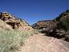
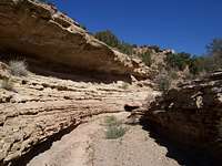 The Narrows
Crescent Canyon is one of my more favourite places in the Bookcliffs because of the ease of navigation, the astounding solitude, the mining history involved with this place and that there are three canyons that make up this entrenched massif.
Crescent Canyon starts out as an unassuming wash in what is essentially a scared and open basin located west of Blaze Canyon. The central portions narrow down to a moderately cut but still open passage that gives easy access to the higher reaches. The sedimentary strata and layers through this section are amazing as they show the layering quite well. The higher reaches of Crescent Canyon open back up briefly and then narrow down again into some spectacular scenery.
There is also a Right-Hand and a Middle branch that is accessed from below in the basin.
Located even further west and more conveniently accessed via a Wilderness Study Road, is the Crescent Mine (5,715ft). There is a standard brown fiberglass marker located at the beginning of this short road where one can choose to park at or continue on down the rough 4x4 road for an additional .4-.5 mile to an obvious cut created by storm runoff/erosion that runs directly through the road. There are some old timbers buried here from a long ago bridge.
There isn’t much left at the mine but scattered debris, a fair amount of timber/wood from what I’m assuming to be a central bunkhouse of some kind, scattered mining equipment and two shafts, one vertical and one horizontal. The mine operated from 1920-1948 and was primarily used for coal.
Crescent Canyon is not difficult to reach but it might take one some navigation to find. It is a pleasant and very easy hike and solitude is 100% guaranteed.
Crescent Canyon is located as one of many ranked quad points within the quadrangle of Floy Canyon South.
View Larger Map
Getting There
 The approach...
Detailing the eastern approach, exit I-70 at Thompson Springs at exit #187.
Travel north up towards the cliffs driving through the ‘fingernail’ town of Thompson Springs on Main Street. This will switch into Sego Canyon Road (or Cty. #159) about a half mile outside of town. Follow this north for 3.6 miles. Pass the two right hand Jeep roads on the right side (at mile 3.5) and take the next left onto the Jeep Road at 3.6 miles. This is also known as #331. Follow this excellent and well-maintained dirt & hardscrabble road for approximately 11.8 miles.
The scenery along this stretch is amazing and incredible. There are a few 4x4 spur roads along this segment but ignore them. After taking two of them, they all cliff out to the south. Stay on #331. The road at mile 11.8 will delve down sharply into a wash and cross over to the other side. There is a brown wilderness study marker in the bottom of this wash. Either park here at coordinates: 39° 01’ 93”N// 109° 47’ 94”W or continue up into the wash following the tire tracks of which there are usually a few sets.
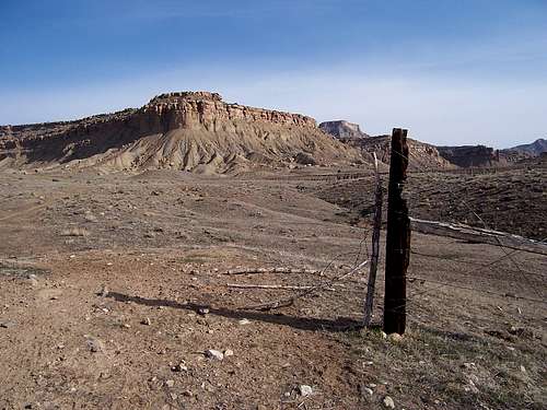
Crescent Butte (6,872ft) dominates the skyline directly to the northwest. The altitude here is 5,428ft.
On a side note, as previously mentioned, it is possible to reach Crescent Canyon from the south and this is actually more direct. Leave the ghost town of Crescent Junction-Brendel, which is exit #182 off I-70. Follow Railroad road to the northwest across open pasture and at a fork in the road, take the right-hand fork (#224) and this will climb up into the lower recesses of Crescent Canyon and join up with #331.
From this T-intersection, it is only .3-.4 mile (towards the right) to the proper wash. I’m not sure if this open pasture is private or not. There is some DOE land/buildings very close nearby so I don’t recommend this route in.
The Canyon
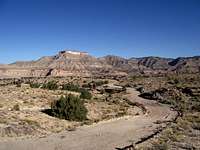
 Crescent Flats
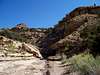
After the first 1.1mile, things will start to get interesting. The canyon never really truly constricts but it does narrow significantly enough to attract ones attention. The next 1.2 miles is scenic as the stratum from the walls is quite obvious. You’d almost expect to see bones or fossils buried and sticking out.
An odd thing is that there are occasional pieces of mining equipment strewn in the wash from the first split into the upper recesses. Using a USGS Floy Canyon South 7.5’ quad map, I cannot locate any mines anywhere except for the Crescent Mine, which is located 1.5 miles southwest. Weird.
There are some side washes on the left (meaningless) and the canyon will eventually split. This split occurs at 5,636ft. and at coordinates 39° 1’ 90”N//-109° 47’ 92”W.
The left canyon quickly peters out after .75 mile. Proceed 26°m into the right canyon and follow for either the whole ~3.3 miles or at leisure. The canyon in this upper portion takes on a different face as it becomes entrenched and deeper because of the increasing ridgelines and more scenic.
Follow your course in as your exit.
As another option, the Crescent Mine is worth a side trip to visit. This mine used to produce coal in the early part of the 20th century and was shut down due to a run on the vein. It is a quiet and lonely place with nothing left of the buildings or mine save for debris, splinters and jetsam.
It's mind-boggeling walking around among the ruins to know this area actually supported a small human population. Makes you wonder if life was all about work & money. In the summer, it would be hot as hell.
Camping
Pretty much all of Crescent Canyon is BLM land.so as far as camping is concerned, throw your stakes anywhere that looks good.
However, you might want to consider a few things first: wash's, cacti, cryptobiotic soil, ant mounds, sunhit, etc...
And remember, leave no trace.
Red Tape
This is good advice to heed even though you'll see tracks of previous vehicles heading up into the wash.
Jeeps with good tires and ATV's can continue up for a deal longer but the question to ask is,
"What's the weather gonna do in a few hours?"
Getting your vehicle out of water soaked sand would be nigh of impossible. Heed on the side of caution.