
|
|
Canyon |
|---|---|
|
|
39.05222°N / 109.72139°W |
|
|
Hiking, Scrambling, Canyoneering |
|
|
Spring, Summer, Fall, Winter |
|
|
Overview
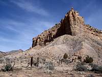
 Entrance to Thompson Cyn.
Thompson Canyon is one of the exceptions. This is a fairly wide canyon where the only necessities one really needs apart from standard desert faire is a sturdy pair of boots and map. Thompson Canyon is a delight. It is easy to access with some interesting features, a few short side canyons and remarkably easy to navigate.
The Sego Canyon petroglyphs, a bit of a misnomer is located in the early stretches of Thompson Canyon about 3.5 miles north of Thompson Springs. In addition to the petroglyphs, Thompson Canyon also offers some ruins and old homestead sites, a pleasant ~5.3 mile canyon drive to the roads terminus and over nine miles of canyon hiking which doesn’t include the side canyons (Right Hand Branch, Renegade Canyon).
Take the time to explore Thompson Canyon. Chances are you’ll have the whole place to yourself.
View Larger Map
Getting There
 Confluence of Sego & Thompson Cyns.
Follow County Road #159 (Main Street) as it heads north through Thompson Springs passing Seward and Harris Avenues. Once past the triple R.R. crossing, there will be two signs for the Sego Canyon petroglyphs. County Road #159 will head directly up into Thompson Canyon passing by the petroglyphs (on the left) and will eventually morph into a jeep road.
If coming from the west or the Moab Valley, merge onto I-70 east at exit #182 at Crescent Junction. Travel an additional five miles east to the Thompson Springs exit and follow the aforementioned directions above.
* There are no services at Crescent Junction (4,900ft) as many who know who use #191 to get into Moab. There is a remnant shell of a long-ago abandoned diner and a DOE site located out of view to the north. Any hiking or canyoneering done north of Crescent Junction will eventually lead you up into Crescent Canyon or even Floy Wash if one ventures far enough west. The terrain eventually cliffs out and spills into Renegade Canyon, an offshoot of Thompson Canyon. Past this, Uintah and Ouray Indian Reservation land lies.
There are Jeep Roads (#223 and #224) and numerous cattle trails that cross the entire area north of I-70 from this junction. If you decide to follow some of these, it is imperative that you have along a map and compass. It’s almost guaranteed that you will not see anyone else.
* The town of Thompson Springs (5,134ft) has only the Shell station; gasoline is expensive, more so than what’s available in Green River or Moab. In fact, it’s about the same as what you can expect to pay in Vail.
There are no other services in Thompson Springs.
The Canyon
Vehicle friendly:The first part of Thompson Canyon is navigated via CR #159, a short ~5.3 mile dirt road. For the first 3.5 miles, it is indeed, the ONLY road. At roughly mile 3.0, the Sego Canyon petroglyphs are viewable and accessed to the left side (west). There is a small parking area, a couple picnic tables and an outhouse. The petroglyphs are impressive to see especially since they are at least 725 years old. Each of the four panels reflects a different culture except for the forth (located slightly up the road near an old cattle round-up corral). It is damaged fairly extensively from gunshots and graffiti. The following four tables are taken directly from their corresponding plaques:
General Information:
The sandstone cliffs that stand above you like a wall become an outdoor art gallery, or a holy place. Native Americans painted and chipped their religious visions, clan symbols, or records and events onto the cliffs. There are three distinct styles or events, which represent three separate cultures and time periods known to have been in the area during the past several thousand years.
This impressive site, which is on the National register of Historic Places, is undergoing a long-term conservation and preservation treatment. The Antiquities Act of 1906 and the Archaeological Resources Protection Act provides for serious penalties to vandals. To ensure the ancient art’s preservation, please do not touch it, as oils in our skin cause the delicate paint and rock surface to deteriorate. Many recent signatures are present. Why did others sign their names at this valuable site? One can only speculate, please do not add your signature or try to remove any of the signatures.
Indian Rock Art should be left undisturbed for future visitor’s to enjoy and scientists to study. It is best to visit this site as one does in a museum. Look but do not touch. Please remember to take nothing but photographs, leave nothing but footprints.
1st Panel: Ute Indians
The historic Ute rock art is identified and dated by the horse and rider figures. Horses were introduced to North America by the Spanish in the sixteenth century. Other figures, or elements, painted in red and white on the panel include a white bison, a human figure with leggings, several large human figures, and large circles believed to be shields.
 Ute Canyon Panel
The Ute people practiced a hunting, and gathering lifeway. They used the bow and arrow, made baskets and brownware pottery, and lived in brush wickiups and tipis. The No-tah (Ute people) lived freely throughout Western Colorado and Eastern Utah until about 1880, when they were forced onto reservations.
2nd panel: Fremont Era
The Fremont Culture thrived from about A.D. 600 to A.D. 1250, and was contemporary with the Anasazi Culture of the Four Corners area. It is distinguished by its remarkable rock art. Like the Anasazi, the Fremont planted corn and lived in pit houses and surface stone structures. They constructed a distinctive basketry and made pottery. They had a complex social structure, as is illustrated in their rock art and were highly adaptive to the extremes of their environment. At the top of the panel are the oldest figures. These are the […] of large red painted figures with the rectangular bodies and small heads, which are similar to the Anasazi Basketmaker style. Superimposed on the older, painted figures is a […] of craved (pecked) human figures. Typically, these have trapezoids for the head and body. The most recent Fremont period is also represented by superimposed carvings. They are the deeply grooved outlines of two life-sized human figures with collars and waistbands, and the associated mountain sheep and abstract elements. This last group is representative of the Classic Fremont Style.
 4th Panel
3rd Panel: Barrier Canyon
Some of the most spectacular examples of rock art in the southwest are attributed to Archaic people. Archaic people were nomads, hunting large and small game animals, collecting and processing wild plants. They did not build permanent habituation structures, but lived in caves and small brush shelters built out in the open. They occupied this area from approximately 8,000 years ago until the introduction of corn agriculture about 2,000 years ago.
 Barrier Canyon Panel
This rock art, the Barrier Canyon style, usually consists of larger than life sized anthropomorphic (manlike) forms. The identifying characteristic of these figures is hollowed eyes or missing eyes, the frequent absence of arms and legs and the presence of vertical body markings. This panel is characterized by at least 19 painted anthropomorphs with bug-eye, antennae, earrings, snakes in hand, and leg-less torsos. The “ghost like” images may represent shamanistic art associated with ritual activities of the Archaic people.
At roughly 3.5 miles, there are two side roads that branch off to the right (east). The first of these passes by the old ruin of a house before it cuts directly through a small dirt ridge. The second turn takes a short diagonal drive up to the top of this small dirt ridge, which I believe is nothing more than a heavily eroded section of the huge wall directly north. Both of these roads will actually meet up on the other side of this low-eroded ridge where they rejoin into County Road #160 before continuing up to the Ghost Town of Sego and disappearing up into the very long valley of Sego Canyon.
Of particular note, on the top of this small dirt dike, is an old cemetery. This cemetery is not labeled on any current maps. I found it on an USGS Quad map (Sego Canyon) 7.5 minute TOPO. It is not viewable from the main road. There are 18 plots of which only 3 are labeled. The rest are simply mounds with various markings and trappings, those of poor souls who have (probably) passed out of memory.
It is a rightfully solemn but lonely place. I actually felt moved and sorry for those forgotten.
Ignoring Sego Canyon for the time being, as this is where Sego Canyon starts, continue to follow the improved dirt road further up into Thompson Canyon. The elevation just past the confluence with Sego is roughly 5,548ft. At mile 4.0, there are three sites of ruins of cabins including what can only be described as an outdoor ‘Dutch-oven’ or a single coking oven. There is also a large patch of Cottonwoods here, an ideal place for a picnic. At roughly mile 4.9-5.0, the improved dirt road will end. This is also where the right-hand branch of Thompson Canyon is accessed.
Park in the hopscotch clearing on the right and continue down the embankment to the wash and continue on foot. The elevation here is 5,840ft.
The remaining .3-mile is on rough (but passable for passenger cars) dirt road. It will end abruptly in a small roundabout near a spring (of which after three trips, I still cannot locate). This is the end of the road and the start of your canyoneering trek.
Time to lace up those boots....
 Sego
SegoPass through this fence (39°03.155N//109°42.983W) and continue on. There is a makeshift barbwire gate located about 30ft to the left but it is difficult to open. Point 6,795 and Point 6,868 will be on your left and right, respectively.
The main canyon continues to the left, apparent by its size. Go ahead and explore the right side (branch) canyon. This will narrow out to its vertex after 30-45 minutes of walking. The next fork or confluence doesn’t come until 45-75 minutes after this first side branch by way of Renegade Canyon (6,386ft).
This is an open, shallow and broad area (39°05.120N//109°44.794W). Some maps have this designated as well as the remainder of Thompson Canyon as marsh or wetland. There are a few steep finger canyons along the deeper recesses of Thompson (~6,720ft) but nothing exploreable as they all cliff out and end abruptly.
Upper Thompson Canyon does maintain its breadth. The underbrush to both sides actually thickens and becomes more entangled and dense. There are some steeper side walls along the dying portions and probably worth deemable of some exploration. Just keep in mind scratches and scrapes are inevitable. Follow the canyon for as long as is deemed reasonable. Retrace your steps.
Renegade Canyon is also worth a side trip if you have the time. The terrain is unremarkably similar to Thompson Canyon but noticeably narrower. Renegade Point is a flattened point on the upper left. This point, if climbed which, would be a feat, provides an entry into Crescent Canyon just one canyon over.
Sego Canyon is hard for me to include here. Reason being it does not offer much in terms of hiking or trekking. There is a main road (in good shape) that winds its way through the whole of the canyon and ends at Hell’s Hole, a gate that marks the boundary of the Uintah and Ouray Indian Reservation. Past this gate, the road and canyon disappears into the Roan Cliffs and the West Tavaputs Plateau. There is a massive parking area located here for hunters during season. The trees and terrain are very different at the top of Sego Canyon as compared to what is initially encountered at the bottom.

Past the old town site of Sego (about 1.2 miles), the road will drop down into Sego Canyon proper and course its way for about 2.2 miles before it starts to rise in elevation. There is very little opportunity to explore side canyons. But, Sego Canyon is deeper cut then Thompson and does offer some very good scenery.
At the top of Sego Canyon at Hell’s Hole gate, the reservation does allow hunters to travel across their property during hunting season to access the roadless areas that lie outside of their boundary. The elevation at this point approaches 8,400ft and is very noticeable.
Legends of America: Sego Canyon
Red Tape
Since most of this is BLM land, camping where you want isn't going to be a problem. However, there are the common sense ideals that one may one to keep in mind, those being cryptobiotic soil (or if you're Christian Slater, "Endangered Dirt"), camping in washes (flash flooding comes to mind) and of course, leave no trace ethics.There is some private property issues that one needs to avoid during the road segments of the canyon early on but due to traffic coming and going along this short initial section, it's doubtful one would want to do anything but car camp.
Scott - Oct 4, 2020 7:45 pm - Hasn't voted
A few updatesA few updates, mostly minor. "There are no services at Crescent Junction" There is a gas station at Crescent Junction. It's rather pricey. "The town of Thompson Springs (5,134ft) has only the Shell station; gasoline is expensive" It's now a 7-11 and has gas about the same price as in GJ or Green River and cheaper than Moab. A huge RV Park is being built in Thompson Springs. Much is built and a lot is under construction. There seems to be a lot more traffic to the pictograhs than I have seen in the past.
Kiefer - Oct 5, 2020 11:32 pm - Hasn't voted
Re: A few updatesThanks for these updates Scott!! As soon as I'm finished with revamping the Wilson Peak page, I'll take care of this. Thanks for the heads up.