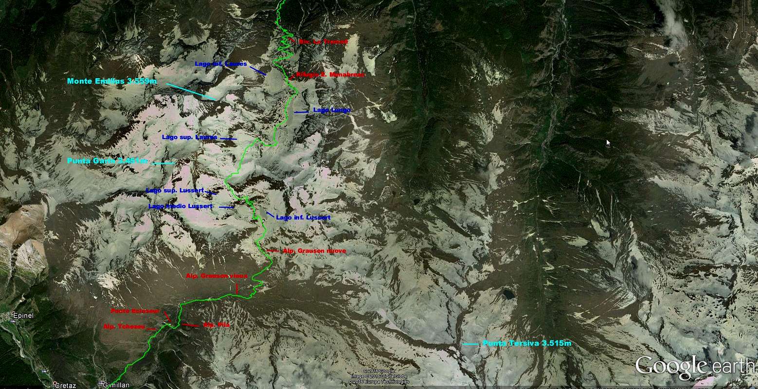
This route is the most direct transit between the Cogne Valley and the central Dora Baltea going through the two Vallons of Grauson (South) and Laures (North) departing from Fraction Gimillan (1.787m) and arrive at the Municipality of Gran Brissogne (897m), immediately to the West of the City of Aosta. Allows the visit of almost all the lakes in the Group of Mount Emilius (3.559m) and surely the most beautiful and important, such as the four Lussert the High Valley of Grauson and three Laures into the namesake valley, between the Northern buttress of Monte Emilius (Blantsette-Seneva-Père Laurent) and the small mountain range of the Grande Roise (3.357m; Punta di Leppe-Punta Ilario Antonio Garzotto-Punte Gianni Junod-Petite-Roise Becca and Tour de Salé). During the ascent you can admire the entire Chain of the Gran Paradiso, while you have some good shots on the eye Grauson Tower (3.240m), Pic Garin (3.451m) and, farther East, to the Punta Tersiva (3.515m); on the way down into the Valley des Laures ranges on the same Group of Roises but, above all, splendid glances over the great and difficult East Face of Mount Emilius that here rushes with 500 meters vertical imposing itself on the tiny Glacier de Blantsette, now in decisive phase of withdrawal.
Questa via costituisce il transito più diretto tra la Valle di Cogne e quella centrale della Dora Baltea passando attraverso i due Valloni del Grauson (Sud) e delle Laures (Settentrione) con partenza dalla Frazione di Gimillan (1.787 m) ed arrivo al Comune di Gran Brissogne (897 m), subito ad Occidente della Città di Aosta. Permette la visita di quasi tutti i laghi esistenti nel Gruppo del Monte Emilius (3.559 m) e sicuramente dei più belli ed importanti, come i quattro di Lussert nello Alto vallone del Grauson nonché i tre delle Laures nello omonimo vallone, compreso tra il contrafforte Settentrionale del Monte Emilius (Blantsette-Seneva-Père Laurent) e la piccola catena montuosa della Grande Roise (3.357 m; Punta di Leppe-Punta Ilario Antonio Garzotto-Punte Gianni Junod-Petite Roise-Becca e Tour de Salé). Durante la fase di salita si può ammirare l'intera Catena del Gran Paradiso, mentre si hanno dei bei colpi di occhio sulla Torre Grauson (3.240 m), il Pic Garin (3.451 m) e, più lontano ad Oriente, la Punta Tersiva (3.515 m); durante la discesa nel Vallone des Laures la medesima spazia sul gruppo delle Roises ma, soprattutto, con splendidi squarci di vedute al di sopra della difficile Parete Est del Monte Emilius che qui precipita con 500 metri verticali imponendosi sul minuscolo Glacier de Blantsette, ormai in fase di netto ritiro.
Getting There
BY CAR:
From Torino, Milano, etc: Motorway A5. Exit at Aosta Ovest. Drive to the near Aymavilles. Follow the directions for Valle di Cogne.
From Switzerland: through the Grand Saint Bernard Tunnel or the namesake Pass. Drive to Aosta, then follow the direction for Courmayeur on SS.26. Just after Sarre, turn to the left, in the direction of Valle di Cogne.
From France: through Mont Blanc Tunnel or Petit St. Bernard Pass. It isn't necessary to take Motorway A5: you can drive on SS.26, in the direction of Aosta. Before arriving at the Village of Sarre, turn right following the sign for Valle di Cogne. After Aymavilles, the SR.47 crosses the Villages of Vieyes, Epinel and Cretaz and after about 25 Km arrives at Cogne (1.534m). From Cogne you can get the Village of Lillaz (1.617m).
BY PLANE:
Aeroporto "Corrado Gex" Saint Christophe (Aosta).
Route Description
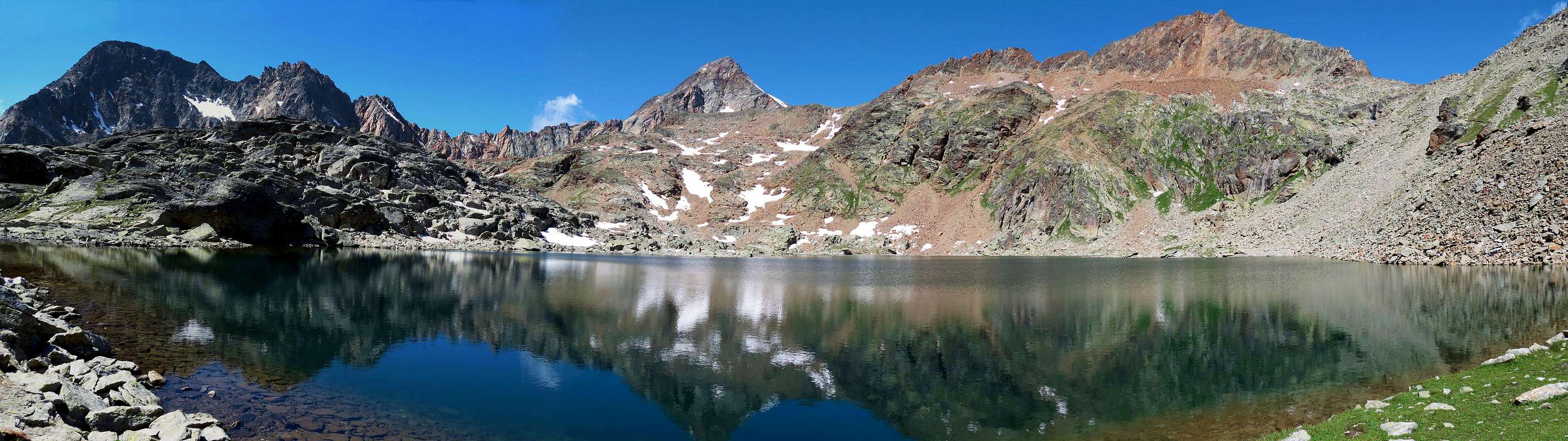
From Gimillan Village towards Col des Laures passing three Lussert Lochs From Gimillan: (1.787m) go right starting from the car park 1.800m~ of Gimillan: after few meters the indications for Lussert Lakes, St. Marcel Pass, etc. are found. The pathway is indicated by the yellow circle n° 9A and by yellow strips marked on stones along the route. The path begins going immediately uphill, then the slope decreases as we go beyond Révènti Alp (1.906m; ruines) and a little Chapel dedicated to the Virgin (1.836m). Soon the same resumes to go up and splits in two, before it begins to penetrate into the Grauson Valley: it's possible to continue following the right (East) one that goes down as far as the Ecloseur Bridge (1.904m; shop-sign Tchezeu Alp; 1.918m), but in such a case we must go up again; it's better to follow the left one that, in practice without losing height, arrives at the bridge under the Pila Alp (2.025m), cross it and, following the stepped pathway, overcome the rocky bastion beside a fine waterfall (at the left). At this point the path turns right markedly, entering, high on the torrent, into a small valley; by an alternation of steep and slight slopes, it reaches a panoramic cross, on the edge of a pleasant plateau (superb view of the far La Grivola!). The path goes through the meadows, slightly descending: after the Old Grauson's Pastures (2.271m), crosses the Doreire Torrent on the Pikaciù Bridge and by a steep trail beside the stream, reach the wide upper part of the Grauson Valley. At the junction before Pralognan Pasture (about 2.400m), instead of going straight ahead along the pathway n° 4 leading to the head of Grauson Valley, go left (North) till to Grauson Nuove Pasture (2.540m), where once there was the burned Tentori Bivouac, on Summer 2000. Along grassy slopes and great blocks by path toward the Lussert Lower Lake (2.721m), then after passing a steep prominence, to the Middle Lake (2.800m) and to the Higher Lake (2.926m). At once before of effluent, the path turn in North direction passing, as a small track, a great boulders area and, after by a brief diagonal, reach the Laures Pass (3.036m; 4h'00/4h'30).
Dal Villaggio di Gimillan al Col des Laures attraverso i tre Laghi del Lussert Da Gimillan (1.787 m): partire dal parcheggio (1.800 m~) trovando dopo pochi metri I "panneaux" con le indicazioni per I Laghi Lussert, il Colle di Saint Marcel o Corona, ecc. Scegliendo quello giallo/nero cerchiato con l'indicazione n° 9A. Il sentiero inizia salendo immediatamente in ripida salita per poi diminuire in pendenza andando verso l'Alpe Révèntì (1.906 m; rovine) ed incontrando subito dopo una piccola Cappella dedicata alla Vergine (1.836 m). Subito dopo lo stesso riprende a salire con falsopiano e dividendosi in due presso un grosso cartello indicatore con piccola tettoia; tenendosi sulla destra (Est) penetrare nel Vallone del Grauson e, tramite una breve discesa, raggiungere il Ponte dell'Ecloseur (1.904 m; cartello indicante l'Alpe Tchezeu; 1.918 m). Attraversarlo sul Torrente Lussert e, lasciate le Alpi Ecloseur appena a destra, con un lungo diagonale a sinistra ed in mezzo ai prati raggiungere la successiva di Pila (2.025 m), con alla sua sinistra una bella cascata. Superare la soprastante bastionata rocciosa doppiandola a sinistra per poi ritornare a destra passando alti sul torrente in una valletta; con pendenze alternate e lievi raggiungere una croce su d'un promontorio panoramico (superbe vedute sulla lontana La Grivola!). Il sentiero attraversa la prateria in leggera discesa: dopo Grauson Vecchie (2.271 m) attraversa sul Ponte di Pikaciù il Torrente Doreire e con un ripido percorso accanto al torrente raggiunge la parte larga e superiore del Vallone del Grauson. Verso la congiunzione prima dell'Alpe di Pralognan (2.400 m~), invece di salire direttamente avanti lungo il sentiero n° 4 che abbandona la testata del Vallone di Grauson, girare a sinistra (Nord) sino all'Alpe di Grauson Nuove (2.540 m), ove esisteva il Bivacco Tentori andato a fuoco nell'estate del 2000. Dall'alpeggio di Grauson Nuove (2.540 m), attraverso pendii erbosi e sentiero aggirante grossi blocchi, raggiungere il Lago di Lussert Inferiore (2.721 m), poi, risalendo un ripido promontorio, quello di Mezzo (2.800 m) ed infine il Superiore (2.926 m). Appena prima dell'emissario, il sentiero gira a Settentrione e, superando una zona di grandi "clapeys" prima, e, con un'esile traccia poi, con un piccolo diagonale finale raggiunge il Col des Laures (3.036 m; 2h'15; in totale 4h'00/4h'30).
Descent in Vallon Laures
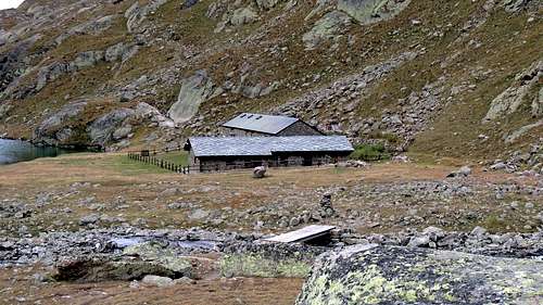
Col des Laures down towards the North with the trail n° 4 reaching the Southeastern shore of the Lac d'En-Haut or Dessous (2.787m), from which the same is addressed decisively to East along the Torrent Montet reaching a small grassy esplanade between large boulders at the end of now extinct Glacier de Lussert (2.763 meters; to the East rises the way to the Colle di Leppe); the next leg, again in the North and by the same path, leads, bending right at the end, the Lac long on the Western slopes of the Grande Roise (2.630m; 1h'00/h1h'15 from the hill). Continuing alongside the Western bank of the same will first reach the Alp and then the Refuge Laures, named after the partisan Ernesto Menabreaz of Grand Brissogne (2.634m, 2.552m; 0h'30). From this via the path n° 1 or the nearby n° 1A, further West and at the Torrent des Laures, you arrive at an altitude 2.191 meters, where both are reunited, and soon after the last Tramail or alp (1.997m); with winding path and at the limit of the forest will get you to La Vieille (1.615m) and from this with hairpin bends that of Arp (1.320m), which ends the private dirt road that goes by the Municipality of Gran Brissogne- Primaz (829m) across the Alp Gremonenche (1.112m; 2h'00 from Laures; by all the 7h'00 to 8h'00 for the whole trip).
Dal Col des Laures scendere verso Settentrione con il sentierino n° 4 raggiungendo la sponda Sudorientale del Lac d'En-Haut o Dessous (2.787 m), dalla quale il medesimo si indirizza decisamente ad Oriente lungo il torrent Montet raggiungendo una piccola spianata erbosa tra grandi massi al termine dello ormai estinto Glacier de Lussert (2.763 metri; ad Est sale la via per il Colle di Leppe); il tratto successivo, nuovamente a Nord e per mezzo dello stesso sentiero, conduce, flettendo a destra nella parte finale, al Lac long alle pendici occidentali della Grande Roise (2.630 metri; 1h'00/1h'15 dal colle). Proseguendo a fianco della sponda Occidentale dello stesso si raggiunge dapprima l'Alpe e poi il Rifugio delle Laures, intitolato al partigiano di Gran Brissogne Ernesto Menabreaz (2.634 m, 2.552 m; 0h'30). Da questo tramite il sentiero n° 1 o quello viciniore n° 1A, più ad Ovest e presso il Torrent des Laures, si arriva a quota 2.191 metri, dove entrambi si ricongiungono, e subito dopo al Tramail od ultima alpe (1.997 m); con percorso sinuoso ed ormai al limite della foresta si arriva all'alpe La Vieille (1.615 m) e da questa con stretti tornanti a quella di L'Arp (1.320 m) , dove termina la strada poderale che sale dal Comune di Gran Brissogne-Primaz (829 m) passando per l'Alpe di Gremonenche (1.112 m; 2h'00 dalle Laures; complessivamente dalle 7h'00 alle 8h'00 per l'intera traversata).
Parents refers to a larger category under which an object falls. For example, theAconcagua mountain page has the 'Aconcagua Group' and the 'Seven Summits' asparents and is a parent itself to many routes, photos, and Trip Reports.

 3121 Hits
 79.04% Score
 10 Votes