
-
 1205 Hits
-
 81.84% Score
-
 14 Votes
|
|
Route |
|---|---|
|
|
45.62100°N / 7.44581°E |
|
|
Hiking |
|
|
F |
|
|
Overview
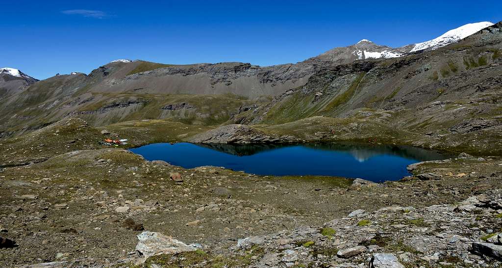
The long and wild Vallone del Grauson (South of Cogne Municipality and North-northeast from Gimillan Hamlet) opens like a fan dividing into various sectors, each of which has a series of splendid lakes. Leaving South those of Money and Tzét or of Testa under the Testa di Money (3.130m) and Pointe Coupée (3.211m), to the Northwest those of Lussert and to the North Lake Corona and that of the Rane ("Frogs's Loch"), we go to visit the various Doreire Lakes, included in a promontory between the Mont Penne Blanche (3.254m) and Punta Tersiva (3.515m). There are four magnificent lakes a little secluded from the world, but well known by those who make an excursion to Pas des Invergneux or Pas des Hevergnes (literally "Winters's Pass"; 2.902 meters). For greater precision, they are located between the Serra Madù or Madou (long ridge to the Southwest of Punta Tersiva; 3.220 meters) and the first elevation of the East Point of Penne Blanche (3.254 meters) or Testa Vallonet (3.152 meters). Let's consider the two most important lakes or Superiore (Highest) and Inferiore (Lower), the other two being of lesser importance, as well as located at an altitude of approximately 2.830 meters. However, nothing prevents you from visiting all four of them, in an environment that is more than wild and can be defined as primordial and, in the distant past, frequented almost exclusively by the local inhabitants as chamois and ibex hunters.
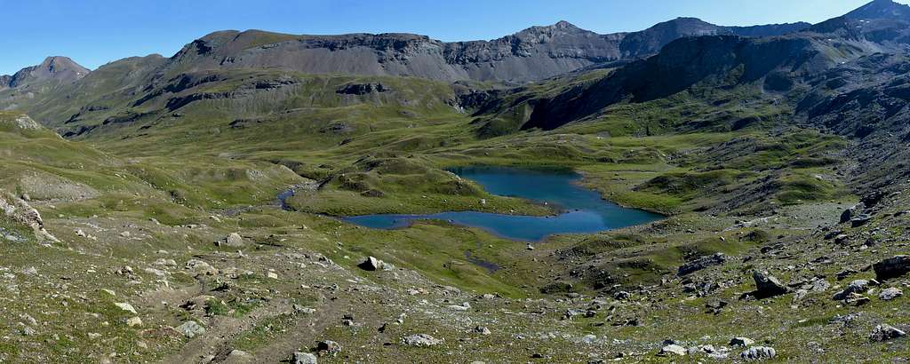
Il lungo e selvaggio Vallone del Grauson (a Meridione del Comune di Cogne e della Frazione di Gimillan) s'apre a ventaglio dividendosi in vari settori ognuno dei quali presenta una serie di splendidi laghi e laghetti. Lasciando a Meridione quelli di Money e di Tzét o di Testa al di sotto della Testa di Money e della Pointe Coupée, a Nordovest quelli di Lussert ed a Nord il Lago Corona e quello sottostante delle Rane, andiamo a visitare i Laghi Doreire, compresi in un promontorio erboso-detritico tra il Mont Penne Blanche (3.254 m) e la Punta Tersiva (3.515 m). Sono quattro magnifici laghetti un poco appartati dal mondo, ma ben conosciuti da chi opera un'escursione al Pas des Invergneux oppure Pas des Hevergnes (alla lettera conosciuto dai locali siccome "Colle degli inverni; 2.902 metri). Per maggior precisione i medesimi si collocano tra la Serra Madù o Madou (lunga dorsale detritico-rocciosa a Sudovest della Punta Tersiva; 3.220 metri) e la prima elevazione della Punta Est del Penne Blanche o Testa Vallonet (3.152 metri). Consideriamo i due laghi più importanti o Superiore ed Inferiore, essendo gli altri due laghetti di minore importanza, nonché collocati a quota 2.830 metri circa. Nulla però vieta di visitarli tutte e quattro, in un ambiente che più che selvaggio é da definirsi come veramente primordiale ed, in un lontano passato, frequentato quasi esclusivamente dagli abitanti locali impegnati come cacciatori di camosci e stambecchi.
Getting There
BY CAR:
- From Torino, Milano, etc: Motorway A5. Exit in Aosta Ovest. Drive to the near Aymavilles. Follow in the direction of Valle di Cogne.
- From Switzerland: through the Grand St. Bernard Tunnel or the homonym Pass). Drive to Aosta, then follow Courmayeur direction on SS.26. Just after Sarre, turn to the left, in the direction of Valle di Cogne.
- From France: through Mont Blanc Tunnel or Petit St. Bernard Pass). It isn't necessary to enter in Motorway A5, you can drive through SS.26 Aosta direction. Before arriving at the Village of Sarre, follow the sign and turn right towards Valley of Cogne. After Aymavilles, the SR.47 crosses the Villages of Vieyes, Epinel and Crétaz and after about 25 Km. arrives at Cogne (1.534m). Follow the road signs for Gimillan and Lillaz (1.607m), 2 Kilometers after Cogne Center; arrived at a round-about, recently built in proximity of the St. Anthony Chapel, go left along the scenic route leading to the Village of Gimillan (1.787m) 2,1 Kilometers after Cogne-Resort. Usually for both no parking problem.
Route Description
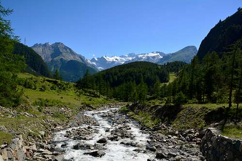
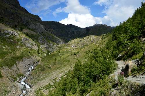
Go right starting from the car park in beaten earth (nearby small wooden bridge above the homonym stream) of the Hamlet of Gimillan (1.778m: after few meters the indications for Lussert Lakes, St. Marcel Pass, etc. are found. The pathway is indicated by the yellow circle n° 9A and by yellow strips marked on stones along the route. The path begins going immediately uphill, then the slope decreases as we go beyond a little chapel dedicated to the Virgin (1.836m). Soon the path resumes to go up and splits in two, before it begins to penetrate into the Grauson Valley: it's possible to continue following the right one that goes down as far as the Ecloseur small Bridge (1.904m), but in such a case we must go up again; it's better to follow the left one that, in practice without losing height, arrives at the bridge under the Alpeggio Pila (2.025m), cross it and, following the stepped pathway, overcome the rocky bastion with a fine waterfall aside. At this point the path turns right markedly entering, high on the torrent, into a small valley; by an alternation of steep and slight slopes, it reaches a panoramic cross, on the edge of a pleasant plateau (superb view of the far Grivola!). The path goes through the meadows, slightly descendind: after the Alpi di Grauson Vecchie (2.274m), cross the torrent on the Pikaciù Bridge and begin again to go up, reaching the wide upper part of the Grauson Valley. For the first time the Tersiva put it in appearance, while, looking into the distance, the end of the valley appears, close by the Passo d'Invergneux (2.905m) and the Serra Madù, WSW ridge of the Tersiva. Shortly afterwards one meets the signs indicating the ways on the left to Laures Pass (3.035m) and St. Marcel Pass (2.916m). On the contrary go straight ahead along the pathway n° 8/TVC, few meters later you can see on the right the Alpeggio Pralognan (2.418m). Continue as far as the ruins of the Alpeggio Ervillières (2.519m), at the foot of the Tessonet's Glacier. Leaving the basal moraines of this on the left, continue instead towards Southeast along the left hydrographic bank of the Torrent of Ervillières (below the Plan Paravère) via the path always n° 8/TVC directed to the Southeast towards the Pass of Invergneux or Pas des Hevergnes (2.902m), right above the four Doreire Lakes. From the confluence of the Torrent Doreire and Ervillières, after having crossed both, turn sharply to the South and, through some steep hairpin bends, reach Lago Doreire Inferiore (2.731/4m); continuing to the West of the same, you leave on the left two other lakes (2.829m) and, turning again to the southeast, you reach Lake Doreire Superiore (2.844m) just below the Pas des Hevergnes or Invergneux (3h'30/4h'00).
Difficulty
The route can be classified as E/F.
L'itinerario è classificato E/F.
External Links
- REGIONE AUTONOMA VALLE D'AOSTA the official site.
- FONDAZIONE MONTAGNA SICURA Villa Cameron, località Villard de la Palud n° 1 Courmayeur (AO) Tel: 39 0165 897602 - Fax: 39 0165 897647.
- SOCIETA' GUIDE ALPINE DI COGNE Tel. 347/9473526 – 328/1373728.
- A.I.NE.VA. (Associazione Interregionale Neve e Valanghe).
- A.IA.T. Cogne Gran Paradis via Bourgeois n° 34 Tel. 0165-74040. E-mail: aiat@cogne.org
- Ezio Sport articoli sportivi - via Bourgeois n° 64 Tel. 0165-74204.