
|
|
Route |
|---|---|
|
|
44.31940°N / 72.8866°W |
|
|
Hike/ Scrmable |
|
|
Half a day |
|
|
Walk-up/ Class 2 |
|
|
Approach
See the "Getting There" section of the main page.
Route Description
This route will take you to the summit traversing through hardwood and evergreen forests, and climbing the mountain's south ridge, returning by the Monroe Trail. The total distance is 7.4 miles with a vertical gain of 2583'.
At 1500 feet the head of the Monroe Trail is clarly marked by a signpost on the west end of the parking lot. Leaving the parking lot you enter a hardwood forest of birch and maple that dominates the majority of the hike.
After you begin the hike in approximately 200 yards you come to a trail register requesting all hikers sign-in. After you sign-in continue to follow the clearly marked trail southwest, blue blazes. The trail gradually climbs, gaining approximataly 750' of elevation over 1 mile. The trail then bears due west and climbs an additional 250' over a third of a mile before it comes to a junction with Dean trail.
Dean Trail will cover 1 mile and gain approximately 600'.
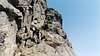
At this junction, take the Dean Trail heading South-South West, but don't break here. Travel another .2 miles to Hump Brook, where you can snack while listening to the brook cascade over large boulders. After regenerating yourself leave the brook and follow the Dean trail past the Hump Brook Camp ground, staying left on the Dean trail. Over the next .8 miles you will gradually climb as the trail slowly begins to turn and head due south. Along the way be sure to take in the views of the summit over a beaver pond (at about .5 miles). As you travel around a second pond you will see the cliffs of the south ridge, which will shortly become your path.
At the junction of Dean and the white-blazed Long Trail turn left and follow the Long Trail northward up the soutern ridge. (If you plan on staying overnight you may head south on the Long Trail and go approximately .2 miles to the Montclair Glenn Lodge).
The Long Trail will cover 1.5 miles and gain approximately 1400'. Begin the SOuth Ridge hike by climbing up rock stairs to the first of two look-out points (some second class scrambling may be required). After the initial climb of about 470' the trail levels off and heads north west. After some minor up and down sections the trail begins the final ascent to the summit.
Your final climb is steep, gaining 800' in less than half a mile, using stone stairs requiring some large steps and class 2 scrambling. As you climb the rocky summit is out of view, hidden by the forest you are hiking through. When the Alpine Trail joins from the East the Long Trail leaves the forest and the summit is in plain view. Follow the white and red blazes around the western side of summit. After the trail goes around the western side of the summit the trail turns east as you climb the final 60' to the summit.
On a clear day spend time enjoying the views of the Adirondacks to your west, Mansfield to the North and the Worcester range to the East. On extremely clear day the Whites are visibale in the far distance. While on the summit be sure to stay on the marked trails or rock sections as you enter an artic-alpine region with fragile plants and zealous summit caretakers.
To return to your car leave the summit by following the Long Trail north. In .3 miles the Monroe Trail comes in from the east, this is your return route (see Monroe Trail from the 'Routes' section. The 3.1 miles return is a gradual path down to your car.
 |  |  |  |
Essential Gear
Seasonal Gear as needed - recommend crampons and or snowshoes for winter hiking.
Miscellaneous Info
If you have information about this route that doesn't pertain to any of the other sections, please add it here.