
-
 6586 Hits
-
 83.69% Score
-
 17 Votes
|
|
Mountain/Rock |
|---|---|
|
|
43.32900°N / 103.5534°W |
|
|
Fall River |
|
|
Hiking |
|
|
3965 ft / 1209 m |
|
|
Overview
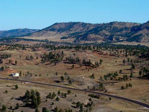 The View North From The Summit
Devil’s Slide Mountain is located ten miles south of Hot Springs, South Dakota along Highway 71. Lists of John only designates the mountain as “3965”. With 370 feet of rise, it ranks #131 in the Black Hills for prominence. Devil’s Slide Mountain is not an official name on maps, but that is the name used by The Nature Conservancy and area residents. Most of the mountain is owned by The Nature Conservancy, which makes it open to the public a majority of the time. The mountain is perhaps best described as a long, steep ridge that has many small outcroppings of rock. Past forest fires have eliminated most of the trees that once covered the mountain. Lack of cover probably inhibits some of the area mountain lions from visiting this mountain as often as they frequent the more-forested mountains in the area. But, deer are often seen here, as are occasional coyotes, foxes and porcupines. A large variety of birds can be seen on Devil’s Slide Mountain, with wild turkeys, vultures, hawks, owls and eagles being the most obvious. Because of the lower altitude and the warm, dry climate of the extreme southern Black Hills, rattlesnakes are in abundance here. Ticks are plentiful in the spring and summer, so caution is warranted for mild to warm weather hikes here. The hike to the summit provides great views at all times, due to the scarcity of trees. The summit area requires a little rock scrambling, and when at the summit, one can easily see to Battle Mountain and the Seven Sisters Range highpoint to the north. There are also good views of Flagpole Mountain to the southeast and numerous canyons to the west and northwest. Though not high in altitude, Devil’s Slide Mountain offers a strenuous short hike with some great views of the area.
History of the Area
 The Old Cascade Ghost Town many years ago
 An old hotel at the Cascade ghost town
For centuries, this area was populated by Native American people, who enjoyed the natural mildly warm springs. The town of Cascade, also known as Cascade Springs, was originally envisioned as a resort area because of the natural warm springs just north of town. Six artesian springs, at the north end of Devil’s Slide Mountain, feed an ever-constant 2,000 gallons of water per minute of 67-degree water into Cascade Creek. Development of the town began in 1888 at the north end of Devil’s Slide Mountain at the mouth of Alabaugh Canyon. Progress moved along at a rapid pace with construction of a large hotel, bank, post office, the Brainerd Indian School, homes and businesses. But greed killed the town as land owners refused land purchase offers from the Burlington & Missouri River Railroad, instead holding out for much higher prices that never came. When the railroad routed to Hot Springs instead, the town began dwindling away, with only 25 people left by 1900.
The Whitney Preserve
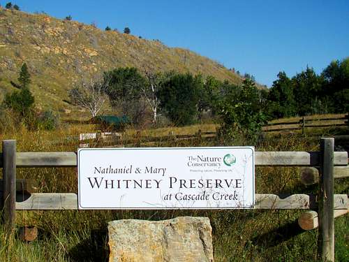 The Whitney Preserve at Cascade.
Most of the land on Devil’s Slide Mountain is located on the Whitney Preserve, which is a part of The Nature Conservancy. It is only a few miles north of the Black Hills Wild Horse Sanctuary. The size of the preserve is currently 4,383 acres, most of which is mountains and canyons. At the Visitors Center, located across the road from the north end of Devil’s Slide Mountain, a half-mile nature trail is open to the public. There are plans to expand that trail in the future. There are not many hiking routes in the preserve, but with permission most of the area is open for exploration. The old roads through the preserve lend themselves to exploratory hikes. Hunting (in season) and bird watching are two popular activities at the preserve. Students of biology and environmental studies often visit the Whitney Preserve.
 Devils Slide Mountain and the Cascade ghost town
Getting There
The best way to reach Devil’s Slide Mountain and The Whitney Preserve is to travel 10 miles south of Hot Springs on Highway 71. There is a major “S” bend in the highway that begins near the site of Cascade Springs and Keith Park. After passing the ghost town of Cascade, the best access to the mountain will be along the east side of the highway. There are several gates in the east side fence that allow safe parking off the highway.
Route Options
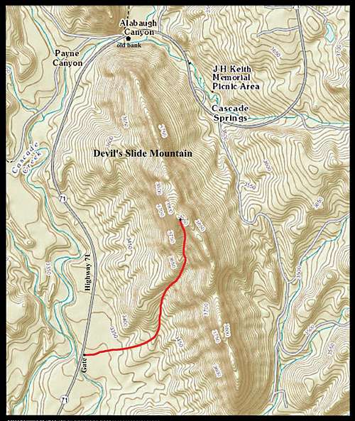 Route Map for Devil's Slide Mountain
There are no trails to the summit, so those wishing to climb Devil’s Slide Mountain will have to choose a bushwhack route. Since Highway 71 runs along the northern and western sides of the mountain, while much of the eastern foot of the mountain is the private property of Cascade Springs Ranch, all routes to the summit will necessarily begin from the highway, whether from the west side or north side. Since the altitude of the highway is approximately 3400 feet, the hike to the summit will see over 500 feet of gain.
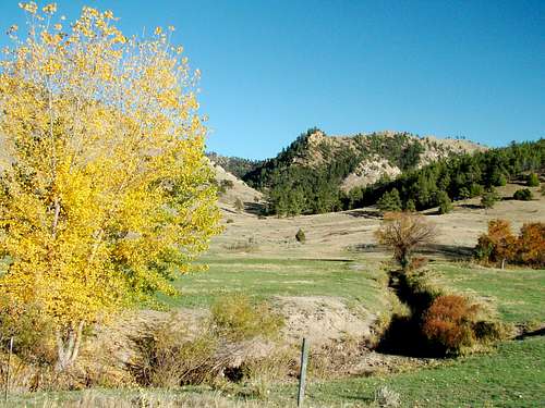 Autumn near Devils Slide Mountain
There are no trails to the summit, so anyone wishing to climb Devil's Slide Mountain will have to choose a bushwhack route. The route on the map makes use of a faint game trail on the upper half of the mountain. Like many game trails, there are places it fades out and then re-appears. Since the upper half of the mountain is the rougher part, it helps to follow that "path of least resistance" chosen by the deer that roam the mountain. The route shown on the map is about ½ mile long and is the best short bushwhack route to the summit. However, the rancher that contracts with the Whitney Preserve for cattle grazing rights in this area says that hiking in from the north, though longer, is less difficult. Besides watching for rocks to trip on and rattlesnakes, please be on the lookout for occasional strands of very old barbed wire, often at ground level and in the brush.
Red Tape
Almost all the land on Devil’s Slide Mountain is owned by the Nature Conservancy. It is best to check with their local official, Kelli Turner, for access permission. She can be reached at (605) 745-6990. Most of the time, there is no problem for hiking this mountain. The main exception will be hunting season closures.
When To Climb
 Devil's Slide Mountain Summit
Except for when The Nature Conservancy closes access during hunting seasons, Devil’s Slide Mountain can be accessed much of the year. Dry late-fall and winter days are probably the best time to hike here. Summer lightning, mid-summer heat and winter storms will be deterrents. You can learn more about the weather forecast and conditions by clicking here: Cascade Springs – Devil’s Slide Mountain – Angostura Lake Area Weather
Camping
 Canyon at Cascade Springs
The closest camping areas are in Hot Springs and at Angostura Lake. The Hot Springs Chamber of Commerce maintains an up-to-date list of area campgrounds, lodging, maps, restaurants and more. You can access each one’s site for more detailed information by clicking on either link below:
Hot Springs Area Camping & Lodging
Cascade Area Information Links
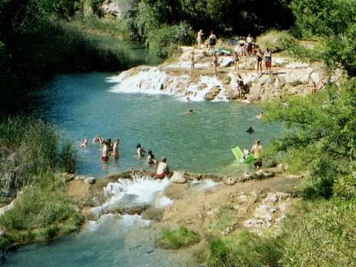 Swimming at Cascade Falls
The National Forest Service manages Cascade Springs, Cascade Creek and Cascade Falls. You can learn more at their website by clicking here: Cascade Springs, Creek and Falls Cascade Falls has great natural outdoor swimming, a picnic area and restrooms. The whole area was recently re-modeled. There are some steep stairways down to the falls and swimming area. Poison ivy is in abundance near the creek and rattlesnake warning signs are plentiful. Caution is warranted. For more details for the Cascade Falls Picnic Area, you can visit this Forest Service site: Cascade Falls Picnic Grounds
Maps
Devil’s Slide Mountain lies in the Cascade Springs Quad. The Black Hills South map, published by National Geographic, is an excellent map for the area, as is the Black Hills National Forest Map, sold at forest service offices in the area. If you are exploring any of the national forest lands in the area, the national forest service office in Hot Springs offers a free Motor Vehicle Use Map for the Black Hills National Forest. Fall River Ranger District 1801 Highway 18 Hot Springs, SD 57747 (605) 745-4107