
|
|
Route |
|---|---|
|
|
48.11140°N / 121.1128°W |
|
|
Basic snow/glacier and/or 4th class rock |
|
|
One to two days |
|
|
Walk-up/scramble |
|
|
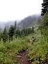
Approach
DRIVING DIRECTIONS (for 2 different approaches to this route):From I5 or Highway 20, take Route 530 to Darrington. Proceed south on the Mountain Loop Highway (Forest Road (FR) 20) following the Sauk River for ~10 miles (mi). At the junction with the White Chuck River road (FR 23) you have a choice that depends on which approach to the White Chuck Glacier you prefer: via the North Fork of the Sauk or the old Kennedy Hot springs trail (if it ever recovers from 2003 floods).
For the approach up the North Fork Sauk drainage, do NOT take the fork to the left, but rather stay right, continuing on FR 20 another ~7mi to a junction with FR 49. Turn left at this fork and drive ~6mi to a spur (just before a bridge crossing the North Fork/Sloan Creek confluence). About 100m down this trail reach the North Fork Sauk trailhead.
APPROACHES FROM THE TRAILHEADS:
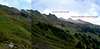
The various approaches from the old Kennedy Hot Springs area are best described in Fred Beckey's Cascade Alpine Guide volume 1: Columbia River to Steven's Pass. You basically want to get to the meltwater lake at the base of the White Chuck Glacier by bushwacking/traversing E from the PCT at about 5000' across the Glacier Meadows and the upper White Chuck River drainage.
The approach from the North Fork Sauk River trailhead via the White Pass area begins with an ~8mi hike up the North Fork of the Sauk River to the PCT between Red and White passes. The first 5 miles is a relatively gentle climb from the trailhead (~2200') to just past Mackinaw Shelter (~3100'). Then 2.8mi of steep switchbacks lead up to the alpine zone and the PCT (6000'). Proceed S along the PCT 0.7mi to White Pass (~5904'), a signed campground, and/or a spur that leads NE ~1/4mi to good campsites (plenty of water in late July) on the SE flank of White Mountain.
 |  |  |
Details of approach from White Pass
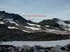
To reach the White Chuck Glacier from the White Pass area, Beckey recommends you leave the NE spur to climb through the lowest saddle (~6500') on the ridge that extends NE from White Mountain. He then directs you to traverse the complicated "gentle" terrain of the basin to the N and rise gradually to the White Chuck Glacier (at ~6800'). I found the descent into the "gentle" basin pretty damn steep and the gradually rising traverse very confusing (in the dark).I recommend reaching the White Chuck Glacier by a slightly different route that involves a higher initial saddle, but less elevation loss in the "gentle" basin. Rather than going for the lowest saddle NE of White Mountain, continue on the well-beaten spur trail traversing ~1.5mi to the SW edge of the Foam Creek basin. Traverse off the ridge to the NE, negotiating a short section of steep scree and a convenient terrace, and then ascend to the grassy saddle (~6650') at the head of Foam Creek. Once over the saddle, descend meadow, talus, and snow fields to the upper reaches of the "gentle" basin. Hop the creek (~6400') beneath the impressive cliffs (W face of Peak 7587) and climb N over rolling meadows and boulder fields to a broad, rocky saddle (6250'). Hike N as the saddle widens to a plateau and find the S side of the White Chuck Glacier in ~3/4mi.
 |  |  |  |  |
Essential Gear
Although the route can be climbed without traveling over glaciers, an ice axe is recommended to make glissading on snow fields safe. If you choose a route/variation that involves any glacial travel, the normal complement of ice axe, crampons, helmet, rope, and rescue equipment should be utilized because crevasses are present, and they often intersect the paths of potential falls (ugh).Water is unavailable from Glacier Gap on. Bring the USGS topo map to assist in the approach to the White Chuck Glacier. The Green Trails map is not detailed enough to navigate the upper White Chuck river basin efficiently, especially when visibility is low.
If you leave a Northwest Forest Pass for your car at either trailhead you may get a thank you note (we did!); the alternative is an increasingly common $50 fine.
 |
Route Description
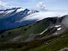
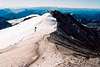
Once at the White Chuck Glacier traverse across and/or skirt its edge, rising up the NE lobe towards Glacier Gap (7250') a col where the White Chuck and Suiattle glaciers meet (or nearly meet). There is flat ground for camping here.From near the Gap, work ~1/2mi N around a hump by either traversing its eastern side via the upper slope of the Suiattle glacier, or passing to its west by climbing about 100' vertical over a saddle. Continue past the hump ~1/2mi to attain the Disappointment cleaver which begins as a gentle ridge and sharpens to the N. Follow the cleaver N towards Glacier and watch the summit disappear begind Disappointment peak.
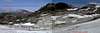
As the cleaver steepens, choose to ascend directly over Disappointment Peak (4th class), or slip past it by climbing the upper edges of the Gerdine and Cool glaciers. Descend ~150' from the summit of Disappointment Peak (9755') or traverse from the glaciers to a continuation of the cleaver/ridge (~9600). Trudge up ~3/4mi of pumice sand/scree to steeper blocks and/or a snow chute to reach the summit caldera (10541').
 |  |  |  |  |