
|
|
Route |
|---|---|
|
|
48.12955°N / 121.12221°W |
|
|
Mountaineering |
|
|
Spring, Summer |
|
|
A few days |
|
|
Glacier Climbing, possible short ice sections |
|
|
1 |
|
|
II |
|
|
Overview
This is a nice glacier route on the north side of the mountain, with some interesting terrain at the top of the mountain. Do it in early season to avoid an unpleasant 500-1000 ft scramble through the moraine and talus at the south base of Kennedy Peak. Although a bit longer than the typical Boulder Basin/Sitkum Route, it is more varied climbing, and the marmots on the north side of the mountain are not nearly as aggressive as those in Boulder Basin. And you avoid that ugly Boulder Basin approach from the Pacific Crest Trail!Getting There
REALLY TOUGH RIGHT NOW!!!The usual start is at the White Chuck River Trailhead East of Darrington. The hike 5 miles on the White Chuck River Trail #643 to Kennedy Hot Springs (will it still be called that when access is restored?) and the Kennedy Ridge Trail #639 from there get you to the Pacific Crest Trail #2000. Unfortunately the October 2003 storms wiped out the Hot Springs, a victim of global warming. The Kennedy Ridge Trailhead is now inaccessable as well due to the floods at the same time -- the road having been wiped out not far from the Mountain Loop Highway.
That being the case, the next best approach would be from the north, but the Suiattle River Road #26 is also closed beyond Downey Creek. Construction/repair is scheduled for Fall 2006 according to the Forest Service web site. It gets worse. From Sulphur Creek Campgound (the end of the road, when it is fixed!) one used to be able to take the Suiattle River Trail #784 up to the Milk Creek Trail #790. The PCT is 6.5 miles up the Milk Creek Trail. Alas, the floods also took out the bridge across the Suiattle at the beginning of this trail, making it inaccessable.
(If you note that either of these roads has been repaired, please let me know so I can revise this write-up!)
Route Description
For anyone willing to invest the time and trouble to get to the NW side of Glacier via the PCT, here is an outline of the climb from the PCT to the summit.FROM NORTH leave PCT to ascend toward Kennedy Peak. I'll get a description of how to do this, but I have not been on that route. Actually late season this would probably be the best approach to Frostbite Ridge, as it avoids the nasty talus/moraine slope and broad gully from 6000 to 7000 ft on the standard route.
FROM SOUTH leave PCT 1.5 mile north of Kennedy Ridge Trail at gully/creek crossing (Glacier Creek) onto a climbers trail that continues up the gully at a point where the PCT switches back westward.
Continue up creek, trail climbs and crosses an old lateral moraine of Kennedy Glacier.
There are good camp sites at around 6200 ft and plentiful water, near what the USGS topo shows as the toe of the glacier. Continue east toward gap below the south wall of Kennedy Peak. Snow early season, ugly moraine/talus later season.
Turn south up snow/glacier toward the prominent ridge between Kennedy (right) and Vista (left) Glaciers. Generally few crevasses. Head toward the Rabbit Ears, selecting either glacier or bare ground as conditions and party dictate - there is a climbers trail on the cinders and scree of the ridge, but some may prefer to stay on the glacier.
Below the Rabbit Ears at around 9400 ft the ridge becomes a noticable rib. Bear right of the rib to avoid steep snow/ice, moving to an somewhat exposed ramp above the Kennedy Glacier.
Slip through gap in rib to last pitch of steep snow/ice, most will want protection on this section, particularly mid- to late-season. One pitch of 40+ degree ice gets to near the base of Rabbit Ears. Check out Z-Man's nice shot down this slope at the top of this report. Rather than going through the doorway gap and up the steep snow/ice, it is possible to stay right if willing to do a class 4 scramble to get around the Rabbit Ears rather than through them.
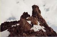 Backside (south slope) of Rabbit Ears - photo credit: Z-Man
Ascend through the Rabbit Ears, drop (scramble) down 150 feet to a small saddle.
Ascend another sometimes-steep section of snow/ice (~200 ft) to NE ridge of the summit crater, which becomes its north rim.
Drop to crater floor (10,200) and cross to wall on south side.
Ascend the south crater wall (pick your poison -- sometimes ice, may be easier a bit to the right (west) of the north ridge of the summit area.
Continue west to the summit.
Descend the route. There is a nice belay horn (probably with plentiful, if old and untrustworthy, slings) above the steep ice north of the Rabbit Ears to rappel the one pitch of steep ice to the doorway gap in the rib.
Essential Gear
Glacier climbing gear, including a helmet.A couple of ice screws are a good idea for potential use on the steep slope below the Rabbit Ears, and later season they might also be used to get out of the crater and onto the east summit ridge.
Vote!
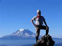 Random spire on the Gilbert Peak West Route - Adams in the background Photo credit: Andrew
The neat thing about web resource such as SummitPost.org is they are so easy to edit in response to comments or suggestions. Please return to the top of the page and provide a page score on the pages you visit. You may also send a quick note to the authors with ideas on how to improve their descriptions!
Thanks -- Keep Climbing Mountains, and Don't Slip!