-
 8771 Hits
-
 85.78% Score
-
 21 Votes
|
|
Mountain/Rock |
|---|---|
|
|
41.70658°N / 23.49779°E |
|
|
Hiking, Mountaineering, Trad Climbing, Aid Climbing, Scrambling |
|
|
Spring, Summer, Fall, Winter |
|
|
8957 ft / 2730 m |
|
|
Overview
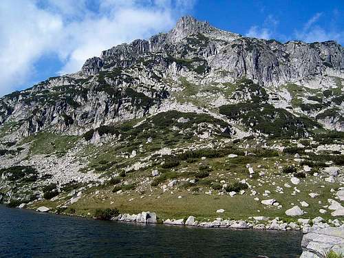
Djengal is a rocky peak, situated in the Northern part of Pirin. It is one of the most inaccessable peaks in the mountain.There are different versions about the name "Djengal". Most probably it comes from Turkish and it means "tassel", as it comes from the prominent outlook of the peak.
The West face of Djengal is suitable for trad climbing. It is about 120 metres high and built of solid granite. For topos of two routes on the face follow this link.
Getting There

From "Bezbog" hut - The trail that starts from the hut splits after a while. The right one leads to Bezbog peak and the left one - to Popovo ezero (Papaz gjol), situated right below Djengal.
From "Tevnoto ezero" shelter: There is a marked trail on the slopes of Momin Dvor that leads to Djengal. It takes about 1:30 h to get there. The trail starts from the hills right above the lake and the shelter.
From "Demjanica" hut - Both trails to "Bezbog" hut and "Tevnoto ezero" shelter are marked well. It's possible to take a shortcut if the visibility is good or if you have a GPS track.
Red Tape
No permits or summit fees required, no seasonal closures, no parking fees.Djengal is situated in the Pirin National Park, so there are special rules regarding environment and wildlife.
Visit http://www.pirin-np.com/English/pirin-np_E.htm for more information.
Camping
There are several huts and shelters in the area:1. "Bezbog" hut
-situated near "Bezbog" lake
-accessible by cable way starting from "Gotse Delchev" hut (accessible by road from Dobrinishte)
-altitude: 2236 m
-capacity: 130 beds
-running water, electricity, central heating, restaurant, bar
-phone numbers: 048 / 90-62-09, 97-40-88; 0888 / 28-61-02
-coordinates: N41.73434; E023.52475
2. "Demjanica" hut
-situated where the rivers Valjavishka, Vasilashka and Strazhishka join
-altitude: 1895 m
-capacity: 217 beds (main building and 14 wooden huts)
-running water, electricity, heated by wood stoves, restaurant
-web site: http://www.demianitza.hit.bg/
-phone numbers: 048 / 96-93-39; 0888 / 91-57-74
-e-mail: demianitza@yahoo.com
-coordinates: N41.74285; E023.46786
3. "Tevno ezero" shelter / camping ground
-situated on the shores of Tevnoto ezero (lit. Dark lake)
-altitude: 2515
-30 places in the shelter and about 20 in tents next to it
-food and drinks offered during the summer
-phone number: 048 / 80-82-91
-coordinates: N41.69942; E023.48321
External Links
Pirin National ParkClimbing Guide (page for Djengal)
A photo gallery (text in Bulgarian)
"Demjanica" hut
Pirin at Wikipedia