
|
|
Mountain/Rock |
|---|---|
|
|
41.75659°N / 23.40062°E |
|
|
Hiking, Mountaineering |
|
|
Spring, Summer, Fall, Winter |
|
|
8645 ft / 2635 m |
|
|
Overview
Hvoinati Vrah (or Juniper Mount) is located in the Pirin Mountains of Bulgaria, immediately South of Vihren and North of Muratov. It is also prominantly located immediately West of the Vihren hut. At 2635m Hvoinati Vrah is only about the 35th highest in the range but is accessible to anybody climbing Vihren and a straightforward ascent.The normal way to climb the peak is either from the North via the Vihren Pass or from the South via the Vlahin Pass. The former is the easiest if ascending from the Vihren hut with the gradient not exceeding around 30 degrees and can be completed in a couple of hours. In winter the Eastern slopes can be climbed directly from the Vihren hut. Alternatively, there is a series of broad couloirs on the North side. There is also a small buttress on the North-Westerly aspect with potential for short winter climbs. From the summit there are excellent views of surrounding Pirin peaks.
 North side of Hvoinati Vrah. The summit is the rounded peak in the right half of the photo
Getting There
Getting to Bansko
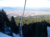 Bansko Gondola
Bansko (936m) is the gateway to the Pirin Mountains. From Sofia’s Central bus station there are around six buses daily. On entering the bus station buy your bus ticket from the counters to the right. The journey takes three hours. A few buses also depart from Sofia’s Ovcha Kupal bus station in the SW corner of the city.
Bansko can also be reached by train however the route is longer albeit more scenic. If travelling from Sofia, first take a train to Septemvri, which is on the main Sofia-Plovdiv line. Then take the narrow gauge railway to Dobrinishte (5 hours) which is 6km East of Bansko. On route you will pass through Avramovo, the highest Balkan train station. There are around five trains a day although two of these leave rediculously early.
For further information on train travel within Bulgaria please visit the Bulgarian State Railways website.
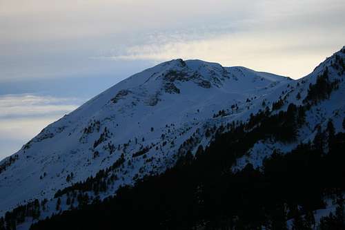
 Hvoinati Vrah at dusk
Reaching the Vihren Hut
During summer there are a limited number of buses running between Bansko and the Vihren hut. Alternatively take a taxi.
In winter there is no public transport other than the Gondola which extends 6km South to a spot called Banderishka meadow at the foot of the ski lifts. The gondola journey time takes around 20 minutes. From here you must walk which will take between 90 minutes and 2 hours.
Red Tape
No permits are required to enter the parkNormal national park rules apply
If you think you need a visa for Bulgaria then check with your local embassy
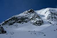
 View of summit from North View of summit from North |
 View of summit from South View of summit from South |
 Buttress on NE aspect Buttress on NE aspect |
Camping
The Vihren hut (Hizha Vihren), a short distance to the North-East, or the Sinanitsa hut, to the South-West are the most convenient huts to stay. The Banderitsa hut a short distance north of the Vihren hut is another option if the Vihren hut is full.A short distance South of the Banderitsa hut in the direction of the Vihren hut there is a camping ground.
In Bansko there is numerous accommodation due to a construction boom in recent years - far beyond current demand. The result is that some parts of town have become an eyesore with many half finished apartment blocks. My recommendation would be to find somewhere in the heart of the original town which lies either side of Pirin St.
 Pirin Mountains from Bansko Pirin Mountains from Bansko |
 Vihren Hut in winter Vihren Hut in winter |
When to Climb
Summer is the optimum time when conditions are easiest at the summit can be hiked to without encountering snow.Winter is a beautiful time to visit Pirin although come prepared for plenty of snow. Bare in mind that huts will be unstaffed and you will need to be self reliant.
Mountain Conditions
10 day forecast for Sandanski - This town is located at the foot of Pirin to the South-West.6 day forecast for Bansko
Webcams for nearby Todorka peak are available here
 Hvoinati Vrah at sunset
Maps
From personal experience, I managed to find no maps covering the Pirin Mountains prior to arrival in Bulgaria. In Bansko I found two maps available.The most widely available is the Domino map of Bansko and the Pirin National Park. It has a red cover, is sold by numerous vendors but in my opinion is not very good. The side of the map dedicated to Pirin has as much space dedicated to hotel advertising as to actual mapping.
By far the better map is one by Iskar Tour which has an olive green cover. This covers the Northern half of Pirin which includes all the major peaks. It has a scale of 1:40000 with 25m contour lines and is excellent quality. There is also a map of Bansko on the rear. The map can be viewed online here
A third map by Kartografia also covers Pirin (1:55000 scale) although I did not find this in Bansko (but is likely available at outdoor shops in Sofia).
The map below shows Hvoinati Vrah's location. It is just South of the number "20" marked on the red line.
 Pirin map
Alternatively, I've accurately marked the peak on the Google Earth map (click on the coordinates above).
External Links
The official Bansko municipal website.This website also has some good Bansko info
More to Follow SOON...