
-
 9462 Hits
-
 79.04% Score
-
 10 Votes
|
|
Route |
|---|---|
|
|
48.72480°N / 113.6497°W |
|
|
Mountaineering |
|
|
Spring, Summer, Fall |
|
|
Most of a day |
|
|
Class 4 |
|
|
Easy |
|
|
Overview
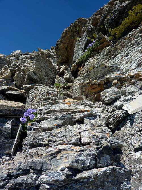
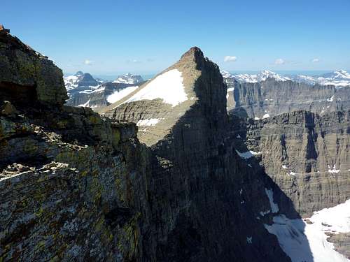 A rewarding view of Siyeh and your scree walk the rest of the way. | 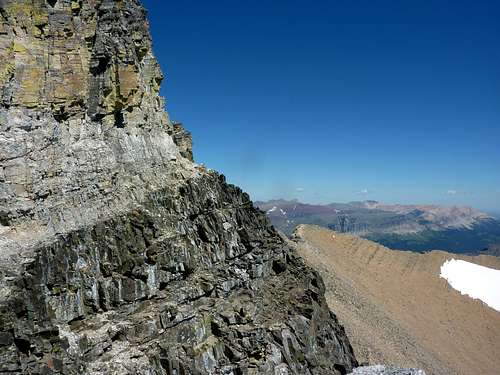 Actually there are multiple ledges in there you could take. But "my" ledge is obvious where white and black meet. |  The Skyline Experience takes in every peak visible along the right side of this photo. The Domino Crackers Traverse is a handy little shortcut that still takes in the most impressive section of the famous ridge walk. |
Mount Siyeh is climbed often. This popular peak in Glacier National Park is the only one of the six 10,000 foot peaks which can be climbed in a day, and in half a day by strong parties, at that. The peak is also positioned centrally in the park allowing for startling and beautiful views in every direction. A further appeal is the North wall of Siyeh itself, 4,200 impressive feet- one of America's largest walls. Below Cracker Lake sparkles, and across the "pond" below you sits red squat Allen Mountain, a shudder of scree nearly a mile tall itself. Mount Gould gives you a beaming thumbs up, and the Garden Wall is just as sheer as Siyeh's own cliffs, making for dramatic pictures, with rows and rows of mountains, arrayed like a phalanx of soldiers, each beckoning, silent, sparkling in the sun, as if calling to be climbed. This is a fun non-technical route not taken by many, but marked with a few cairns for the first half, and so, probably not a first ascent. It involves easy scrambling of Class 2 and 3 with a very exposed traverse of 40 feet or so that makes the traverse on Mount Merritt's infamous Old Glacier Route look like a cake-walk across a 6-lane highway. To summit Siyeh you will actually have to summit Peak 9833 first on this route, which has been designated "Cracker Peak" on USGS Topos, I am told. It may appear under that name on some maps. Thus, this route combines the brevity and directness of the South Slope Route, with the ridge-walking and peak-bagging and views of the Skyline Experience. For that reason, I consider this the finest route possible for the peak. I discovered it via the accident of misreading my Edwards guide and thinking I needed to hike all the way to Siyeh Pass. At the pass, I thought the route obvious, but was told by a local and frequenter of the park and this trail that I had blown it, would never make the summit that day and no possible Class 2 or 3 route could possibly exist under any circumstances from where I was standing and that I was a fool or insane to think so. (I paraphrase.) There is a route and it is certainly no slower, longer, or more difficult than the South Face, which I descended. Frankly, I thought the South Slope route was "Scree Purgatory" and that the views were wanting.
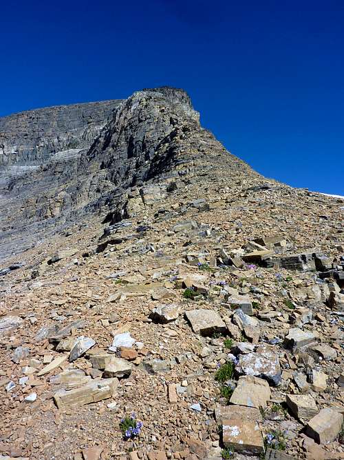
 After an easy stroll across partly-vegetated slopes from Siyeh Pass, this begins the transition from walk to scramble and looks up the whole South ridge of Cracker Peak, AKA Peak 9833. | 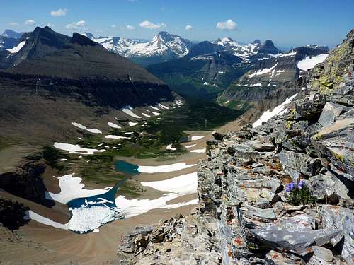 Preston Park with unnamed lakes below, Mahatapi Peak on the left. Jackson and Gunsight Peaks, as well as Reynolds in distance. | 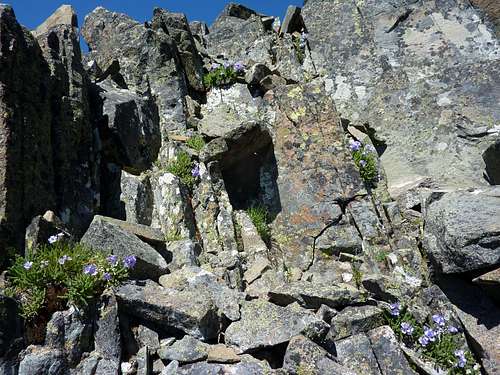 More flowers. |
Getting There
Approaches will be the same as for the South Slope or South Face route, with several trailhead choices available. From Many Glacier, or the Going to the Sun Road at either Siyeh Bend or the Jackson Glacier Overlook shuttle stops/trailheads, one would walk to Piegan Pass and Preston Park. Distance from either of the Going to the Sun Road trailheads is much shorter than from Many Glacier. Roughly 5 miles before beginning ascent. Distance is 10+ from Many Glacier launch points. Elevation change is least from Siyeh Bend. Whatever trailhead you choose, walk all the way to Siyeh Pass. From Siyeh Pass, scan the ridge to the North of the pass across some vegetated slopes. It is a ridge, so the general way to go should be obvious. If it is not, perhaps you should not be in the mountains.Route Description: Domino Crackers Traverse
 Still on Class 2 very easy terrain. | 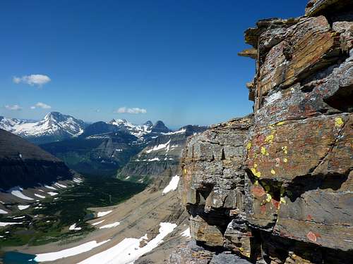 No worries. These can be skirted. | 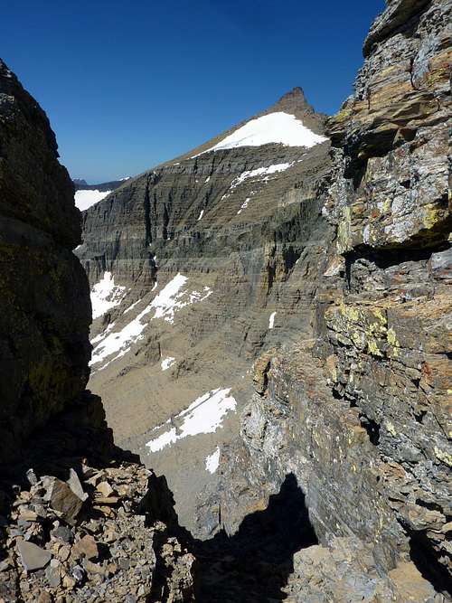 The notch. Not part of the route, except as a cool diversion. |
Walk across the slopes north of Siyeh Pass. This is an open park-like area, with gentle rocky open terrain. You will pass a few small tarns or melt ponds, and probably striations of grasses and flowers, as well as snow earlier in the year. The ground is striped or swirled with varying mixes. Try to stay on the rocky sections so as not to harm gentle little plants doing their best, and which marmots depend upon. Make your way up the scree and onto rockier terrain, picking any way you want to go. The target is to find any path you like up to the summit of Cracker Peak. Options are both plentiful and singular: which is to say, you are on a ridge, so any footing and handholds you choose while going up are just fine, but deviation will be limited. The going is easy and the views are grand. As you climb, the icy and blue lakes of Preston Park directly below sparkle and invite you to take long pictures out to distant Gunsight and Jackson Peaks, among others, likely bright and shining with snow. Purple flowers climb out of the black and red scree, which gives way to more solid materials, and eventually all black rock, covered with bright orange, yellow, neon green, and pale silver lichens. This makes for quite a sight. Black rock, or the diorite sill, is usually not your friend in Glacier Park, but on this particular mountain, that layer is shattered into forms and spires, skyscrapers, inspired and inspiring towers, all easy to breech. Cairns will likely lead you upward to a shoulder where the black rock layer meets the white, if you do not care to pick your own route, but it is hard to go wrong. Class 2 gives way to easy Class 3 and progress is as fast as you wish, and as fast as picture-taking will allow.
When the black rock suddenly meets pure white rock, as clean as snow, your progress is checked and the cairns end at a flat shoulder, ideal to take a good sit on. A fine notch facing the West makes impressive pictures shooting along those hideous scree slopes of Siyeh which you could be grunting and suffering through right this moment. On the East face of Cracker Peak there is an obvious ledge, marked exactly where the black and white rock layers meet. This ledge system is in places only 6-8 inches wide, but you can keep your feet level the entire way and there are always handholds. Exposure is fabulous and a fall will be unpleasant, and leave you gashed and bleeding in the best of cases, but would only be fatal in the very worst cases. The top of the black rock marks the end of your cairn-guided adventure and is the point where parties will determine if they wish to proceed or not. Either you enjoy exposure or not. If you do, then the traverse is a simple affair, over in under thirty seconds. If it looks terrifying, turn around and live to see another day. This is no endeavor for shaking knees. The traverse leads around a blind corner but feeds onto wide-open shattered scree slopes, akin to those of Siyeh's South Face or Slope route. Because of the wonderful black and white meeting of two kinds of rock, and because I play dominoes endlessly when car-camping between day hikes, I christened this little crux "The Domino Traverse" originally. And because I cannot quite part with a youthful enthusiasm for eccentric names that sound cool and exotic, I am re-dubbing it "The Domino Crackers Traverse" after learning Peak 9833 is called Cracker Peak. Whether that name sticks or is replaced, is not up to me. Just as two filthy prospectors cannot have imagined their personal story of forgotten crackers would eventually become the permanent label for both a lake and the peak towering over it, I cannot guess what, if anything, anyone will call this little route of mine! I am sure it has been called other things by at least a few people, because it is just impossible for me to imagine that no man or woman has ever shuffled across that ledge before to summit Mount Siyeh.
I am always a little unclear on what makes a thing Class 4 as opposed to Class 3 or low Class 5, but since the moves are all on one level, and the exposure is great, we will call it Class 4 so people do not get annoyed with me for making the thing sound simpler than they may consider it. Whether the traverse is Class 4 exertion, I cannot say, but I do believe it would be a Class 4 fall, should you make one.
 Typical of the Class 3. | 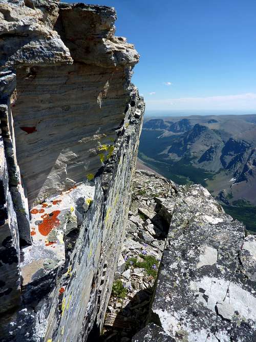 Plenty of cool stuff along route, which not all Siyeh routes can claim. | 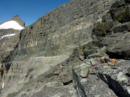 Steps. Hard to pick a wrong path in this black section. |
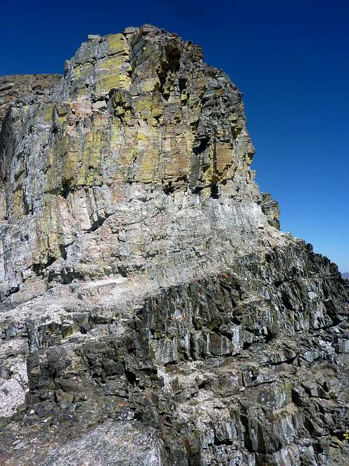
Less than 15 minutes are needed to pick any line you like and summit Cracker Peak, AKA Peak 9833, which offers a grand vantage of Siyeh itself, missed by those who do not take the Skyline Experience (or this route as of it becoming known!). This view of Siyeh is quite rewarding and gives you another 20 minutes to appreciate the accomplishment of your day. Take pictures, take a break before stepping onto the ridge, if you want to eat or apply sunscreen, or even just relieve your kidneys before stepping into a chilling and deafening typical ridge-wind of Glacier Park, and savor the whole time. I actually prefer pictures along the section from Cracker Peak to the summit more than the pictures from Siyeh's true and impressive summit, though those are magnificent as well!
The route can be retraced to create a loop from Siyeh Bend taking in Sexton Glacier and Sunrift Gorge, or your party can proceed West and try the South Face Route back to Preston Park, or the West Scree Run towards Morning Eagle Falls and North of Piegan Pass. Both of those will be looser crap, prone to ankle breaking, or sometimes called (by me) "Treadmill Scree". I suggest the loop down Sunrift Gorge to view another pretty area of the park. An option with a car shuttle is to start at Siyeh Bend, taking the free park shuttle system and descend to Many Glacier. Siyeh Bend or Jackson Glacier Overlooks to Sunrift Gorge do not require a car shuttle.
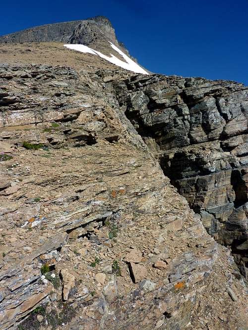
 Gives perspective how near the summit of Cracker Peak, or Peak 9833, you will be for the traverse. | 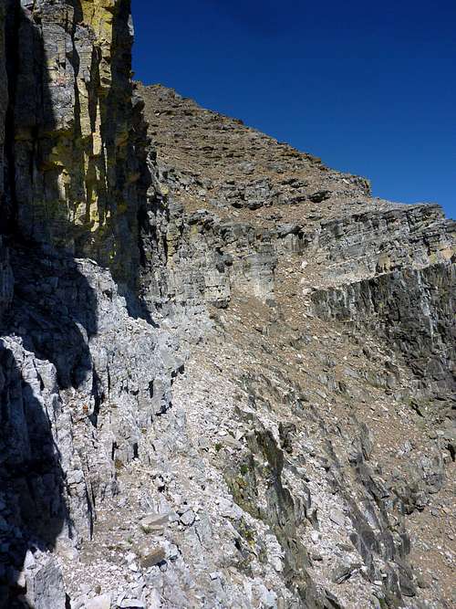 The path to the summit becomes clear and easy after rounding the blind shoulder on the traverse. | 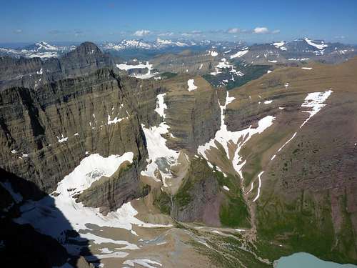 Cracker Lake, poorly captured is barely visible in lower right. Mount Gould and the Garden Wall stand behind the salute of Siyeh's famous and fabulous North wall. Mount Merrit in upper right, the ramp of the Old Sun looking inviting, and the Livingston Range far distant, rugged and remote. |
Essential Gear
No technical gear is required, though a short rope might be a good idea for parties where one or more members are not used to exposure. Those not on the ledges could brace themselves and form a belay, though this would not remove the danger of a minor fall on sharp and jagged rocks to stepped ledges below, which would still likely produce bad cutting and bruising, and likely bleeding, if not worse. But the rock is solid in the whole area and there are actually multiple ledge systems, or stepped ledges that could possibly be taken. I went solo with few qualms, other than not knowing if the traverse would lead around the blind corner or peter out.Plan on being mostly unprotected. Water is available along route seasonally beyond Preston Park. Do not count on the little melt ponds early in season or in late fall. No water is probable on Mount Siyeh or Cracker Peaks. Pack enough food for a whole day as this route will take at least half a day, and Mount Siyeh can easily become a more involved adventure if the descent is unfamiliar and goes slow. Reading new routes in GNP can be difficult and tricky. Expect at least some minor mishaps and take first aid and headlamp. I always advise an alpine axe for protection if attacked by goats or other animals.
Hey, it can happen.
External Links
http://www.nps.gov/glac/planyourvisit/shuttles.htm
http://www.wunderground.com/weather-forecast/US/MT/Babb.html?MR=1
http://www.wunderground.com/weather-forecast/US/MT/Saint_Mary.html
Weather can change rapidly. Clouds move faster in GNP than any place else I have been. Babb, MT is the nearest town to Many Glacier area of the park. St Mary is the closest town to the Going to the Sun Road, and is the Eastern terminus of that road. Trust your own eyes above a forecast as you climb.
Steps. Hard to pick a wrong path in this black section. | 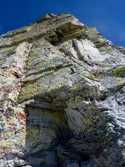 Looking up at some sharp 5th class above The Domino Crackers Traverse. | 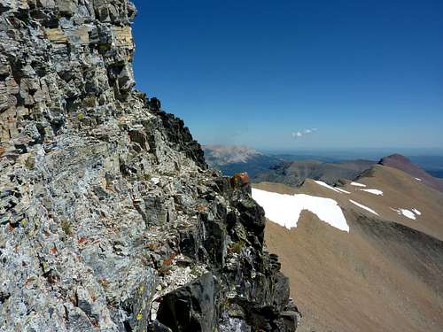 A good proof of the exposure. Terrific fun if you like this sort of thing. |