
-
 33673 Hits
-
 89.77% Score
-
 30 Votes
|
|
Route |
|---|---|
|
|
48.79539°N / 113.6556°W |
|
|
Hiking, Mountaineering, Scrambling |
|
|
Summer, Fall |
|
|
A long day |
|
|
Class 3 |
|
|
Strenuous |
|
|
Overview
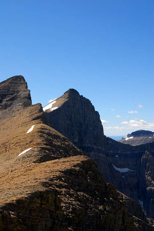
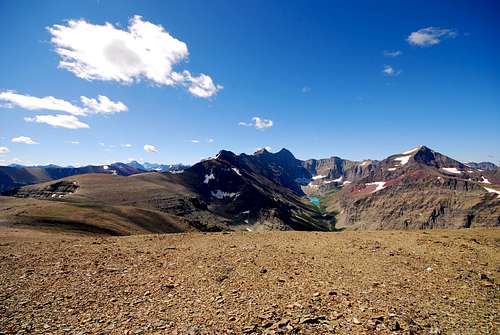 The Skyline Experience in all its glory. Taken from Wynn Mountain, this photo shows the 5 1/2 mile ridge in its entirety, culminating at distant Mount Siyeh, whose north face towers high above beautiful Cracker Lake.
Glacier National Park is world-renowned for its seemingly endless hiking opportunities. There are over 700 miles of maintained trails in the park, which afford visitors the chance to see beautiful glacial lakes, traverse the Continental Divide and many stunning mountain passes, and view a wide array of flora and fauna. I had the pleasure of working in the Many Glacier Hotel during the summer of 2008, which meant that the famous Many Glacier Valley was my backyard for nearly four months. Needless to say, it was the experience of a lifetime. I went to Glacier with the intention of hiking as much as possible.
After I'd completed a bunch of trail hikes in the valley, I started talking to some of the veteran employees of the hotel about other hiking opportunities. I found out that for all the great trail hikes that Glacier has to offer, there are an equal amount of off-trail hikes, climbs, and scrambles to enjoy. It was a natural progression; I had been hiking a lot and was in great shape, and the prospect of exploring some of places off-the-beaten path in the park that I loved so dearly was more than enticing. That's how I came to find out about the Skyline Experience.
The Skyline Experience is a marvelous, breathtakingly beautiful route that takes climbers up and over four different peaks, culminating in a summit of Mount Siyeh. This route is explained in detail in J. Gordon Edwards' essential A Climber's Guide to Glacier National Park, which is an absolute must for anyone seriously considering a foray into the rugged backcountry of Glacier. At 10,014 feet, Mount Siyeh is one of the six "tenners" in park, and it affords some of the most spectacular vistas in the entire region. The route is highlighted by a 5.5 mile ridge walk where the views in all directions are utterly astounding.
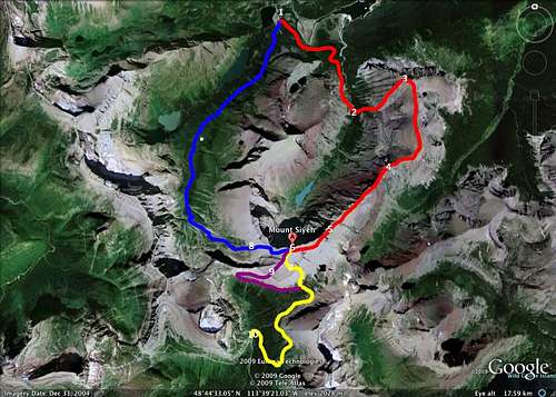
The route starts at an elevation of approximately 4,900 feet at the Many Glacier Hotel, and is somewhere in the vacinity of 16 to 18 miles, depending on the chosen path of descent. This page describes a route that starts on the Cracker Lake Trail, climbs the southeast ridge of Wynn Mountain, heads southeast on the long, scenic ridge to Mount Siyeh, and ends with several descent options towards the west and south, depending on your desired ending point. We completed the hike on August 4, 2008 on a hot, clear day, and it took our group 13.5 hours to complete the entire trek.
Getting There

The historic Many Glacier Hotel along the shores of Swiftcurrent Lake
The Skyline Experience is located on the east side of the Continental Divide, and typically originates from the parking lot of the historic Many Glaicer Hotel. The region is the most remote of all the civilized areas in the park, and is accessed from US-89 via the small, unincorporated town of Babb, MT. A windy, pothole ridden 12 mile paved road leads from Babb to its terminus in the Swiftcurrent Valley; this is the only way to enter Many Glacier via automobile. Babb is 8 miles north of St. Mary, a small, busy tourist village that sits at the easternmost extent of the famed Going-to-the-Sun Road.
Many Glacier can also be accessed via several well-maintained trails. The Highline Trail passes Grante Park Chalet, and detouring east over the Continental Divide on the Swiftcurrent Pass Trail will bring hikers to Many Glacier. The spectacular Piegan Pass Trail (this trail provides access to the south slope route for climbing Mount Siyeh; the Skyline could most certainly be enjoyed in this direction as well, starting with a summit of Siyeh and culminating at Wynn Mountain), which originates at Siyeh Bend east of Logan Pass on Going-to-the-Sun Road, ends along the shores of Swiftcurrent Lake right next to the Many Glacier Hotel. Hikers coming in from the Belly River Valley can also climb up the steep trail through Ptarmigan Tunnel, which terminates at the Swiftcurrent Motor Inn.
Route Description
Wynn Mountain
The Skyline Experience starts from the large parking lot behind the Many Glacier Hotel, where both the Piegan Pass and Cracker Lake trailheads can be found. Take the Cracker Lake trailhead. The trail takes you through thick forest before gracing the western edge of Lake Sherburne, which is actually a large reservoir that serves the lands east of the park. This part of the trail can be particularly nasty in the summer, as the first 2 miles act jointly as a horse trail; be prepared to walk through some muck and manure, especially after rainy days.
After winding around the lake, you come to a small wooden plank that serves as a creek crossing. Immediately after, the horse trail (Cracker Flats) splits to the left, while the trail to Cracker Lake continues to the right. The trail switchbacks steadily uphill for awhile, until you come to a small ridge that affords an interesting view of Canyon Creek downhill to the left. You follow Canyon Creek for another mile or so, until a large bridge crossing the creek is encountered. After crossing the bridge, the real fun begins, as the maintained trail is left behind.
Just on the opposite side of the large bridge, the trail takes a sharp turn to the right; look for the large stream bed that enters Canyon Creek to the hiker's left. Leave the maintained trail at this point and make your way up the creek bed, taking care to avoid slick bolders and potentially swift running water. If at any point you feel unsafe climbing up this challenging terrain, head uphill and bushwhack through the forest bordering the left side of the drainage.
Continue to follow the course of the drainage, and eventually, you'll end up in a flat, open area; from here, you'll notice a large talus field that terminates in cliffs to the northeast. Above these cliffs is the solid southwest ridge of Wynn Mountain, and provides the easiest, fastest path to the summit. After plodding up the talus for 20 minutes or so, the cliff band will be encountered. Look for a loose, class III gully that bisects the cliffs. Scramble up the short gully; once above it, you'll be on the ridge and nothing worse than a tiring class II scramble separates you from the summit. If you cannot find the gully, traverse southward along the base of the cliffs, where you should be able to find a class III route that provides access to the desired ridge above.
The views from Wynn Mountain are exquisite. Slender Lake Sherburne sits directly to the north, with the crumbled, barren expanses of Yellow Mountain and Chief Mountain far off in the distance. To the west, the Many Glacier Hotel perches along the eastern shore of Swiftcurrent Lake. Many Glacier peaks such as Mount Grinnell, Mount Wilbur, and Mount Henkel dominate the foreground, while the monstrous, icy peaks of the Livingston Range tower behind the Continental Divide. Allen Mountain is particularly photogenic from this point, with the steep face that provides access to the summit via an interesting class IV climb in view.
Arguably the most inspiring view is to the southwest, for the entirety of the Skyline Experience spreads out before you. The long ridge leading up and over Peak 9190, Cracker Peak, and culminating at massive Mount Siyeh is clearly visible. The Canyon Creek drainage, headed by gorgeous, aquamarine Cracker Lake, sits nearly 4,000 feet beneath the imposing north face of Siyeh (refer to the first photo on this page, which tries to capture this impressive scene). This view is merely a small sample of the unparalleled scenery that will overwhelm and inspire for the duration of the voyage to Mount Siyeh.
Ridge to Cracker Peak
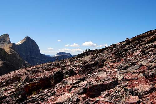
En route to Cracker Peak (left) and ultimately Mount Siyeh (center), whose sheer north face is visible here.4 August 2008
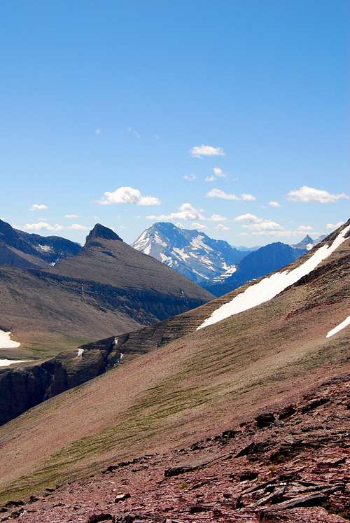
southerly views from the ridge feature massive Mount Jackson
From Wynn, turn south and follow the broad, rocky ridge towards the red spire of Peak 9190. A great game trail will be encountered, which affords solid footing and enjoyable hiking for approximately 1.5 - 2 miles. Eventually the base of Peak 9190 will be reached; at this point, trend to the south (pretty self-explanatory here, as a detour to the north involves tremendous cliffs and frightening exposure) and look for a well-worn trail that gives access to a short, enjoyable class III route to the top.
Views are stupendous, but don't relax for long; there is still a long ridge walk and the tiring climb to Cracker Peak separating you from your final destination. From Peak 9190, it's an uncomplicated descent to the southwest, where the long ridge leading towards Cracker Peak is regained.
Follow the ridge across rocky terrain, enjoying stunning vistas on either side. Looking forward along the ridge is truly a dazzling sight; the sheer north faces of Cracker Peak and Mount Siyeh loom ahead, beckoning climbers to continue their march onward. The footing here is solid, and the ridge affords plenty of space, so there's no danger at all. Just unbelievable views! After traversing a couple of bumps and rocky knobs, the ridge rises steadily as it approaches Cracker Peak. Although the climb of Cracker is quite tiring, it's nothing worse than class III, and requires plodding up small patches of scree and navigating small shelves and cliff bands en route to the summit. Once the climbing begins, the summit should be attained in about 30 minutes.
Cracker Peak (L) and Mount Siyeh (R)
Cracker Peak to Mount Siyeh
Just like the descent from Peak 9190, the route down from Cracker Peak is straightforward and easy. The ridge steadily loses elevation until the saddle between Cracker and Mount Siyeh is reached; after hiking uphill for a short while, one should be pleasantly surprised at how quickly the base of Siyeh is reached. After some class II scrambling, the summit block is encounterd. From here, you have two options. For those who are looking for a slightly easier way to attain the summit, work to the left (south) beneath the summit cliffs, eventually emerging onto the broad, talus-blanketed south slope of Mount Siyeh.
Here, a very well-worn climber's trail will be found, upon which it is a short, easy class II stroll to the summit. At the same time, interesting climbing opportunities are avaialable for those who wish to take a more direct approach. Look for a large break in the summit block; a few feet inside the break, you'll find relatively solid rock with great hand and foot holds that allow you to stem your way upwards. 20 feet later, the break is left behind, and from here it's an easy scramble to the highpoint of Mount Siyeh.
Mount Siyeh
First, a few photos that try to capture the absolutely stunning views from the top...
 |
|---|
The views from the summit are awe-inspiring. A glance back to the east/northeast puts the bulk of the day's work in perspective, as you can see the high 5 1/2 mile ridge connecting Wynn Mountain to Mount Siyeh in all its splendor. To the north, flanking the opposite side of impossibly blue Cracker Lake, is Allen Mountain, with the rounded red top of Apikuni Mountain behind (for another interesting and enjoyable ridge hike, try the Crowfeet/Henkel/Apikuni circuit... it's phenomenal!).
All of the peaks in the Many Glacier Valley are visible to the northwest, including Mount Henkel, Mount Wilbur, Swiftcurrent Mountain, Grinnell Point, and Mount Grinnell. Behind Mount Wilbur and the Pinnacle Wall is a fantastic bulk of rock and ice that includes Ipasha Peak, the unclimbed Lithoid Cusp, Mount Merritt, Old Sun Glacier, and Natoas Peak. Behind that, you get a glimpse of the top of massive Mount Cleveland. At 10,466 ft. it is the highest point in Glacier National Park. The remote peaks of the rugged Livingston Range, including Kinnerly Peak, Kintla Peak, Mount Carter, Rainbow Peak, Vulture Peak, and Longfellow Peak spread out along the western reaches of the park.
Immediately to the west of Siyeh is the marvelously steep east face of Mount Gould, with the jagged spires of the Garden Wall leading southward to Bishops Cap and Pollock Mountain. And to the south one sees the full extension of the Lewis Range, including the multiple peaks surrounding Logan Pass and Sperry Glacier,, Mount Jackson (another "tenner"), Blackfoot Mountain, and even far-off Great Northern Mountain, which lies in the Great Bear Wilderness bordering the southernmost extension of the park.
Descent Options
There are at least three safe routes down from Siyeh, not including a full backtrack down the Skyline ridge towards Wynn Mountain. Our group decided on the first option, but the other two may prove to be of interest depending on your desired ending point.
1) Preston Park (South Slope Route)
![Siyeh South Slope Route]()
route beta of the Mount Siyeh south slope route; PLEASE ENLARGE
Follow the climber's trail southward off the summit, skirting around the west side of a large, permanent snow field that flanks the broad southern slope of Mount Siyeh. The trail will eventually split; head east (left) towards Preston Park. You are descending via the south slope route; refer to the linked route page for a detailed description on how to safely negotiate this potentially complicated route.

route beta of the Mount Siyeh south slope route; PLEASE ENLARGE
Brace your knees for the 2,000 feet of talus and scree that must be descended. A few vague trails make their way down to the east through the loose rock, and following them makes going quite a bit easier. Ultimately, the talus field will come to a terminus at a large cliff band; from here, there are great views to the east of Matahpi Peak and Going-to-the-Sun Mountain, which border the eastern edge of beautiful Preston Park.
From the edge of the top of the cliffs, look for large cairns that will make finding the proper descent couloir significantly easier. You are looking for a broad, loose, class III couloir; if it appears too steep, you are too far north, and need to work your way south along the top of the cliffs until the correct couloir is located. Take care to avoid moving loose rocks while you make your way down the cracks and ledges of the couloir.
Eventually, the cliffs are left behind and you'll encounter a large tongue of scree that makes for a fast final descent into Preston Park. Follow one of many drainages downhill through the forest, heading due east to intercept the Siyeh Pass Trail below. The trail should be reached in no more than 15 or 20 minutes. Once encountered, head right (south). The juncture with the Piegan Pass Trail will be reached shortly. Follow the trail downhill the last 3.5 miles to Siyeh Bend at Going-to-the-Sun Road, where you'll hopefully have a car or ride waiting to bring your tired legs back home.
2) West Couloir to Many Glacier![west couloir descent route, Mount Siyeh]()
west couloir descent route - PLEASE ENLARGE
Gordon Edwards reports a rapid, uncomplicated descent with spectacular scree runs down the west face. I have not attempted this route, but know of three groups who have, and they all seemed to universally think the route was pretty miserable. Lots of small cliffs, and very tiring. Perhaps someone will have success with this route and can share their experiences here on Summitpost! Member alexblondeau has recently uploaded a trip report: see this link for his report plus some photos and video of the interesting descent.
- Start out early on the trail to Cracker Lake. Leave the trail after 3.5 miles and scramble to the top of Wynn Mountain. A glorious, 5.5 mile long ridge leads all the way up and over Peak 9190 and Cracker Peak before culminating atop massive Mount Siyeh. Refer to my route page for details.
- From Rising Sun Motor Inn, take the trail towards Otokomi Lake, eventually venturing off-trail to the summit of Otokomi Mountain. A wide ridge leads to the summit of East Flattop Mountain; from the summit, a short detour to the east leads to Singleshot Mountain. By returning to East Flattop, one can then head north and enjoy the three mile long ridge walk on East Flattop toward Napi Point.
- Check out jimegan's trip report for Red Eagle/Mahtotopah/Little Chief, which involves a glorious ridge walk high above the deep blue waters of St. Mary Lake.
- Mad Wolf Circuit: starting from Cut Bank Campground, it's possible to bushwhack/climb to the summit of Mad Wolf Mountain, where a ridge connects to Eagle Plume Mountain and eventually to Bad Marriage Mountain.
- From the Lunch Creek pullout a few miles east of Logan Pass, the hardy mountaineer can easily summit Piegan Mountain, Pollock Mountain, and Bishop's Cap. You can return to your car near Lunch Creek, head downhill to the Highline Trail from Bishop's Cap, or retrace your steps to the saddle between Pollock and Piegan for a descent to Piegan Pass into Many Glacier. Great route photos and information in Blake Passmore's Climb Glacier National Park; for more info, visit his website: http://www.climbglacier.com/.
- From Two Medicine Lake, hike steeply uphill over three miles on the Scenic Point Trail. From the top, one can enjoy a prolonged ridge walk to the south that includes summits of Medicine Peak and Mount Henry. From Henry, many hikers head towards Appistoki Peak, but options abound, as another long, spectacular ridge leads to Mount Ellsworth and Never Laughs Mountain. Refer to the Climber's Guide or two Blake Passmore's Climb Glacier National Park Vol. 2 (http://www.climbglacier.com/)for detailed information regarding the numerous routes among these peaks.
2) West Couloir to Many Glacier

west couloir descent route - PLEASE ENLARGE
3) Piegan Pass I am not familiar with this route. Rather than detouring west towards the West Couloir Route, continue working southward through scree and talus. A large cliff band impedes further progress; according to Gordon Edwards, there is a class III/class IV couloir that can be safely climbed through the cliffs, upon which you will look for a goat trail that heads to the west towards Piegan Pass.
Leave the goat trail whenever it becomes safe to do so, and make your way downhill to the south, eventually intersecting the Piegan Pass Trail. It's about 4 miles from this point to Siyeh Bend on Going-to-the-Sun Road. From what I've heard about this route, it's rather difficult to find the proper descent couloir. I would recommend avoiding this route unless you have previous experience with it.
Glacier National Park is home to many dangerous animals, including mountain lions, black bears, and grizzly bears. Bring bear spray, a buddy to hike with, a loud voice, and you should be fine.
Bring plenty of water! After crossing Canyon Creek 3.5 miles into the journey, there are no more reliable water sources until Preston Park. Considering you have to gain and lose about 5,000 feet of elevation in between (not including all the ups and downs in between all the summits), you're bound to get thirsty. J. Gordon Edwards describes places to get water near the top of Cracker Peak and Mount Siyeh; however, in the heat of summer, there was only a scant amount of snow up top. It's best to plan ahead and make sure you pack in extra water.
Essential Gear
One more plug for J. Gordon Edwards' A Climber's Guide to Glacier National Park. Great route descriptions of peaks all throughout the park. A topographic map wouldn't hurt, nor would a compass. It would be very difficult to get lost on this route, but the map and compass come in handy for identifying peaks and lakes from the top of these three wonderful summits!Glacier National Park is home to many dangerous animals, including mountain lions, black bears, and grizzly bears. Bring bear spray, a buddy to hike with, a loud voice, and you should be fine.
Bring plenty of water! After crossing Canyon Creek 3.5 miles into the journey, there are no more reliable water sources until Preston Park. Considering you have to gain and lose about 5,000 feet of elevation in between (not including all the ups and downs in between all the summits), you're bound to get thirsty. J. Gordon Edwards describes places to get water near the top of Cracker Peak and Mount Siyeh; however, in the heat of summer, there was only a scant amount of snow up top. It's best to plan ahead and make sure you pack in extra water.
When to Climb
The typical climbing season in Glacier lasts from July - September; of course, seasons with low snow fall will lengthen the season, and vice versa. A large snow drift exists northeast of Peak 9190 on the ridge to Wynn Mountain; it may be present well into the depths of the summer. When we encountered it in August of 2008, it was quite easy and safe to traverse along its broad top. We negotiated it without a rope, ice axe, or crampons, and I can attest that no one in our climbing group felt unsafe doing so.Snow may exist at other points along the route, including the couloirs found on the south slope and west couloir descent routes, so inquire with the rangers about climbing conditions before setting out. Another great resource is the staff at Many Glacier Hotel; a lot of the employees complete this route over the course of the summer, and stopping in and asking someone at the front desk, bellmen desk, or information desk will hopefully help answer any questions you may have.
Where to Stay
The nearest camping is available at the Many Glacier Campground. The entire campground can fill well before noon in the short, busy summer season (June through Labor Day), and there are no reservations; plan on getting there early. Other options include a stay at the historic Many Glacier Hotel or the more modest Swiftcurrent Motor Inn. If you desire to stay near the Going-to-the-Sun Road, options exist at Rising Sun (another very popular campground and a motor inn) and St. Mary (campgrounds as well as hotels, lodges, cabins, etc). Refer to the National Park Service's camping in Glacier webpage for additional information.Other Circuit Routes
Gordon Edwards details several routes that involve high ridge traverses to multiple peaks. It truly is special to spend a significant portion of the day above the tree line, walking atop open ridges with spectacular views in every direction. I recommend giving any of these a try; you will not be disappointed.- Start out early on the trail to Cracker Lake. Leave the trail after 3.5 miles and scramble to the top of Wynn Mountain. A glorious, 5.5 mile long ridge leads all the way up and over Peak 9190 and Cracker Peak before culminating atop massive Mount Siyeh. Refer to my route page for details.
- From Rising Sun Motor Inn, take the trail towards Otokomi Lake, eventually venturing off-trail to the summit of Otokomi Mountain. A wide ridge leads to the summit of East Flattop Mountain; from the summit, a short detour to the east leads to Singleshot Mountain. By returning to East Flattop, one can then head north and enjoy the three mile long ridge walk on East Flattop toward Napi Point.
- Check out jimegan's trip report for Red Eagle/Mahtotopah/Little Chief, which involves a glorious ridge walk high above the deep blue waters of St. Mary Lake.
- Mad Wolf Circuit: starting from Cut Bank Campground, it's possible to bushwhack/climb to the summit of Mad Wolf Mountain, where a ridge connects to Eagle Plume Mountain and eventually to Bad Marriage Mountain.
- From the Lunch Creek pullout a few miles east of Logan Pass, the hardy mountaineer can easily summit Piegan Mountain, Pollock Mountain, and Bishop's Cap. You can return to your car near Lunch Creek, head downhill to the Highline Trail from Bishop's Cap, or retrace your steps to the saddle between Pollock and Piegan for a descent to Piegan Pass into Many Glacier. Great route photos and information in Blake Passmore's Climb Glacier National Park; for more info, visit his website: http://www.climbglacier.com/.
- From Two Medicine Lake, hike steeply uphill over three miles on the Scenic Point Trail. From the top, one can enjoy a prolonged ridge walk to the south that includes summits of Medicine Peak and Mount Henry. From Henry, many hikers head towards Appistoki Peak, but options abound, as another long, spectacular ridge leads to Mount Ellsworth and Never Laughs Mountain. Refer to the Climber's Guide or two Blake Passmore's Climb Glacier National Park Vol. 2 (http://www.climbglacier.com/)for detailed information regarding the numerous routes among these peaks.
samh - Nov 19, 2008 12:28 pm - Voted 10/10
SuggestionsChanging the name to match that of Edwards' is suggested. Also, attach the page to the various peaks as well as to Glacier National Park, et al. Looks good overall.
distressbark - Dec 18, 2008 5:24 am - Hasn't voted
Re: Suggestionsduly noted, thanks for the insight