
-
 21409 Hits
-
 81.84% Score
-
 14 Votes
|
|
Route |
|---|---|
|
|
48.72840°N / 113.6497°W |
|
|
Mountaineering |
|
|
Summer, Fall |
|
|
A long day |
|
|
The Glacier Mountaineering Society rates the climb: III(3)MM |
|
|
Class 3 |
|
|
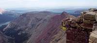
Overview of Mount Siyeh, South Slope Route
 Mount Siyeh from Piegan Pass Trail
Mount Siyeh, West Face Route, Glacier Park Class 2 & 3
The Blackfeet word “siyeh” refers to a rabid or mad animal. In geology, the Siyeh formation, a greenish diorite, is a combination of dolomite and limestone which frequently contains fossilized algae. The previous information is from Place Names of Glacier National Park by Jack Holterman.
Siyeh is one of Glacier National Park’s 10,000 foot peaks and is perhaps the easiest of them to climb. It certainly is the most accessible 10,000 foot peak. Rewarding 360 degree views await those who make this climb.
Statistics for the South Slope Route are approximately 5 miles to Siyeh’s summit from Siyeh Bend on Going-to-the-Sun Highway and a total elevation gain of 4,164 feet.
An up-to-date guidebook for this route can be found in Climb Glacier National Park, Routes for Beginning and Intermediate Climbers; Volume 1: Logan Pass, The Garden Wall, and Siyeh Bend. Purchase it when you arrive in northwestern Montana or purchase it on-line at Climb Glacier National Park.
Information for Mount Siyeh and the South Slope Route can also be found in J. Gordon Edwards, A Climber’s Guide to Glacier National Park pages 263-269. Edwards describes the South Slope Route on pages 263–265.
Fred Spicker has done an excellent job describing Mount Siyeh on the main page.
Views around the Neighborhood

|
|---|
 Looking west from Siyeh Looking west from Siyeh |
 Siyeh's North Face, Aaron Johnson photo. Siyeh's North Face, Aaron Johnson photo. |  Siyeh from Piegan Pass, BritishBulldog33 photo. Siyeh from Piegan Pass, BritishBulldog33 photo. |
 Logan Pass from Siyeh Logan Pass from Siyeh |
 Mt. Wynn Traverse Mt. Wynn Traverse |
 Piegan Pass Trail Sign Piegan Pass Trail Sign |
Approach to the South Slope Route
| To visit Glacier National Park is to enter a place where Heaven touches Earth affording brief glimpses into the Wonders of Creation. |

|
|---|
 Lower portion of climb
Trail Directions:
Park at or ride the Glacier Shuttle to Siyeh Bend. Walk along Siyeh Creek then uphill 1.2 miles to the first trail junction.
At this junction the correct trail follows the left fork as you walk towards the next junction and Preston Park. There are a few creeks flowing off of Going-to-the-Sun Mountain and Matahpi which are on the right. Across the Siyeh Creek drainage to the left is Piegan Mountain and Piegan Glacier. The Piegan Pass/Siyeh Pass sign is 2.8 miles from Siyeh Bend. At this junction take the right fork which leads to Siyeh Pass and the route for Mount Siyeh.
After taking the right (correct) fork continue to walk through Preston Park keeping an eye on the lower slopes of Mount Siyeh. Eventually you will see a portion of vegetation that extends further up the slope than any other slope (Route Diagram). Edwards notes that it is the “eastern most of those green approachments into the talus above Preston Park which leads climbers directly up to the easiest route through the cliffs (pg. 264). Start off through the easily navigated forested area to this point at which the route to Mount Siyeh begins.
South Slope Route Description
 Upper portion of climb
The route through the cliffs is found by following a run-off stream up through the lower portion of the cliffs. Enjoyable scrambing is found through out this section. It may help to have a GPS "breadcrumb" trail to back trace upon descent.
 At top of diorite sill, Fred Spicker photo.
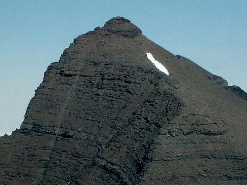 Upper scree slope and summit pyramid block of Siyeh, montanaboy photo.
Edwards notes on page 264 that “when difficult cliffs are encountered (class 4 to 6) traverse a little further to the east until an easier stream bed is reached, then climb up that one.” Route finding through these cliffs is enjoyable and route finding was not challenging.
After working through the upper cliffs mark the entrance to the great scree fields with a GPS or make a cairn. This is also your place for descent.
 Verizon is on Siyeh Summit
From the top of the cliffs continue to climb up and angle slightly to the west to walk below the permanent snowfield near the ridge. After reaching the ridge is a long but beautiful stroll up the climber’s trail to the summit. There are small cliffs just before the summit and these are easily ascended.
The descent follows the same route in reverse. Edwards does note that there are optional descent routes such as the West Couloir Route. The route description does not include information on that route.
 Siyeh Bend Shuttle Sign
Glacier's Shuttle System and Park Entrance Fees
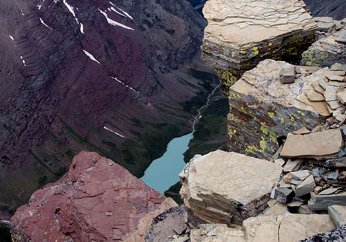 Cracker Lake from Siyeh Summit
The 2010 shuttle system runs from July 1 to September 6, 2010.
Glacier National Park began offering a FREE shuttle service in 2007. This is a great option for exploring the park. The shuttle runs the entire Going-to-the-Sun Highway from St. Mary on the eastern border of Glacier to Apgar, near Lake McDonald, on the park’s western boundary. Some climbs are close enough to the shuttle route and are short enough in time requirements to allow use of the shuttle service. Piegan is one such climb. The earliest shuttle’s depart from Apgar at 7:00 a.m. and generally take 1.5 to 2 hours to reach Logan Pass due to road construction on the Westside of the Logan Pass.
Trips from St. Mary are generally less lengthy and take an average of 60 minutes from St. Mary to Logan Pass. The first shuttle departs St. Mary at 7:00 a.m. The last shuttles depart from Logan Pass at 7:00 p.m.
The Park Service recommends being prepared to wait for shuttles with proper clothing, foot gear, water, snacks and other gear such as sun screen.
See the Glacier National Park’s website for more information at Shuttle Service.
Entrance Fee Information:
Vehicle single entry fee for Glacier National Park is $25.00 for 7 Days, $12.00 per person for single hiker, motor biker or bicyclist. An "America The Beautiful Federal Lands Recreational Pass" for goes for $80.00 which gives entrance to all National Parks, National Forests, BLM, US Fish & Wildlife, and Bureau of Reclamation sites for one year from date of purchase. See Plan Your Visit for other information regarding all of the National Park entrance fee information.
If you are planning on visiting Waterton Park make sure you have a passport to simplify crossing the border.
Weather
 No Camping at Logan Pass
Montana gets its share of interesting weather. On June 8, 2008 over 2” of snow fell in the Flathead Valley and up to 24” inches of new snow in the Glacier National Park high country.
In some years there is record snowfall in the mountains of western Montana. In the recent years all of the northwest Rocky Mountains have been under severe drought conditions. The winter of 2007-2008 finally broke the string of below average snow fall and there is still snow lingering in the high country in spots that usually don’t have snow in mid summer. This certainly has helped hold the wildfires at bay.
Any climbing or hiking in Glacier is much more pleasant if the weather cooperates. To see the latest weather visit Glacier Park Weather.
 Thanks guys for an awesome climb!
There is no camping available or allowed at Mount Siyeh.
Camping at Logan Pass is not permitted.
The options for camping include:
GNP Campground Information, USFS Campgrounds, Camping on the Blackfeet Reservation or East Glacier Campgrounds
Essential Gear
[img:443670:alignleft:small:Thanks guys for an awesome climb!]Hiking poles will aide in your ascent and descent while working through Glacier’s wonderful scree on the side hill approach!
A GPS will also be benficial on this route.
Consider bringing scree gaiters and extra water as well, although there is adequate water throughout this route until the actual off trail portion begins.
As with all hiking and climbing in Glacier National Park use caution and practice good manners with the wildlife. You are in bear country. Carry your bear deterrent spray, don’t hike alone and make some noise. For more information please go to the Park's website for Bear Information. The U.S. Forest Service also has helpful information on Grizzly Bear Management.
Guidebooks and Climber Registration
GUIDEBOOKS:An up-to-date guidebook for this route can be found in Climb Glacier National Park, Routes for Beginning and Intermediate Climbers; Volume 1: Logan Pass, The Garden Wall, and Siyeh Bend. Purchase it when you arrive in northwestern Montana or purchase it on-line at Climb Glacier National Park.
A Climber’s Guide to Glacier National Park; J. Gordon Edwards
Climber Registration: You do not have to register for day climbs in Glacier National Park but it is recommended. Backcountry travel regulations can be found at Backcountry Travel. There is also information from the Park Service on Mountain Climbing in Glacier. Registration for climbing Mount Siyeh can be accomplished at the Logan Pass Visitor’s Center.