
-
 1762 Hits
-
 77.48% Score
-
 8 Votes
|
|
Mountain/Rock |
|---|---|
|
|
38.60328°N / 78.3681°W |
|
|
Trad Climbing, Toprope |
|
|
Spring, Summer, Fall |
|
|
3395 ft / 1035 m |
|
|
Overview
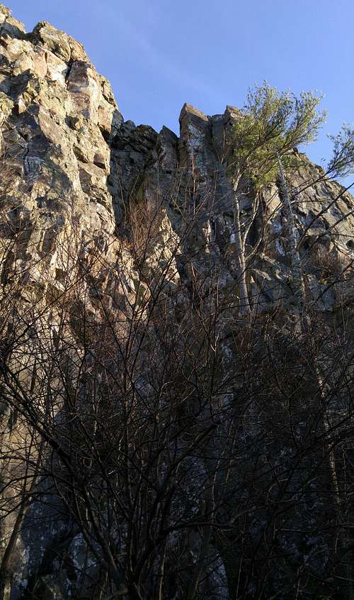
Near the southern end of Little Stony Man, between the Lego Block Area and the NOC Area, the Dragon area has more established trad lines (six) than any other area at LSM, and it is, in my opinion, the best climbing spot there due not only to the number of routes but also their quality and variety. And, because of the pointy pinnacles atop it, the Dragon Area is also one of the coolest-looking spots at Little Stony Man.
At up to 100', Little Stony Man offers the longest single-pitch routes in Shenandoah National Park and perhaps in all of Virginia.
The best resource for climbing here is this online PATC guide, but this page should cover you nonetheless.
Toproping here is a hassle because unless you know the area well, most routes are difficult to locate from the top, necessitating a lot of yelling back and forth with one's partner or extra trips up and down if one is solo; and because you usually will have to build a gear anchor. The Dragon Area is a bit of an exception, though, as there are some okay trees growing near the edge, and they are suitable as one or both anchors for at least three of the climbs (the first three listed in the Routes section). But you should still bring gear.
Getting There
The Little Stony Man parking area is in the park’s Central District at MP 39 on Skyline Drive. If entering the park at the Front Royal or Thornton Gap entrance, drive south. If entering at Rockfish Gap or Swift Run Gap, drive north. Note that there is an entrance fee for Skyline Drive. In 2015, it was either $15 or $20.To get directly to the base of the cliffs, hike on the AT to the junction with the Passamaquoddy Trail, which leads to a ledge offering a great view of the cliffs and then turns left to run directly beneath the cliffs.
Note-- Some boulders and outcrops near the northern end offer interesting bouldering and scrambling, and I have, in fact, done some bouldering there, but current management plans have made for the closure of this area to human activity.
One can also hike to the top of the cliffs instead and then follow The Chute down to the base, but it is much faster and easier to use the Passamaquoddy Trail. The Chute begins south of the open clifftop area.
Routes
From left to right as you face the cliffs:
- Stem City (5.7)-- Climb up the back wall of a prominent chimney to a roof. This roof looks difficult until you actually get to it. To pull it, do what the name suggests.
- Wall of Kaza Dum (5.7)-- Start a little right of Stem City and climb into a chimney and then up a face to a chockstone. This chockstone looks really sketchy from above but is in fact bomber. Pull it and then exit right.
- Easy Does It (5.7+)-- Start on or right of Wall of Kaza Dum and work up steep slabs to a left-facing corner right of that route. Ascend to an overhang and then pull it (makes it more like 5.8) or find an easier workaround. I pulled the overhang with no worries but was on fixed lines (solo TR), not leading it.
To date, I have not climbed the next two, so I am paraphrasing the guide. Both climbs start up a wall that goes anywhere from moderate to difficult with decent pro to none. After the wall, they reach a ledge, and that is where various crack systems define the different routes. There are five cracks in all.
- Dragon's Back (5.7+)-- The large, left-most crack. The guide authors say it takes large cams but do not specify the particular sizes.
- Dragon Cracks (5.8)-- The three cracks in the center of the upper face. The authors mention that a climber usually ends up using all three cracks.
- Right Crack (5.7)-- The right-most crack. I found this hard for the grade, with marginal protection where it was hardest. Actually, at what I felt was the crux, I moved left to the cracks on Dragon Cracks, where I was able to place pro.
Gear: Most climbs at LSM are leadable with a standard rack of stoppers, hexes, and cams.
 Stem City, Wall of Kaza Dum, Easy Does It (5.7-5.7+) | 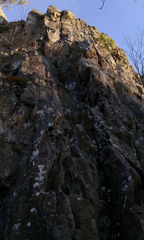 Dragon's Back, Dragon Cracks, Right Crack (5.7-5.8) | 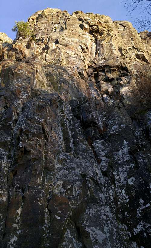 Dragon's Back, Dragon Cracks, Right Crack (5.7-5.8) |
Red Tape
It costs $20 to enter the park, and that provides access for a week. Annual passes cost $30. The interagency pass, good for yearlong entry to areas managed by NPS, USDA Forest Service, USFWS, BLM, and the Bureau of Reclamation, costs $80.It’s common sense to wear a helmet when climbing, anyway, but it’s especially important here since people at the top might toss rocks over the edge.
There are plans to close a section 35 meters north of the Chute and all of the cliffs south of the Chute to human activity. Also, there are plans to use low-impact barriers to close off a boulder area at the north end where the Passamaquoddy Trail bends to approach the base of the cliffs. I do not know when these closures will go into effect; they did not seem to be in effect as of November 2010, the last time I was out here.
The park is open all year, but Skyline Drive does sometimes close after snow or ice storms. The park site does not give current road conditions, so call ahead (540-999-3500).
To reduce poaching, Skyline Drive is subject to closures during hunting season. The information below, copied and pasted from the park site, illustrates the 2006 restrictions—
From November 13, 2006, through January 6, 2007
Skyline Drive
•between Front Royal (Mile 0 at U.S. Highway 340) and Thornton Gap (Mile 31 at U.S. Highway 211), and
•between Swift Run Gap (Mile 65 at U.S. Highway 33) and Rockfish Gap (Mile 105 at U.S. Highway 250),
will be closed daily between 5:00 p.m. and 8:00 a.m.
The central portion of the Drive, between Thornton Gap and Swift Run Gap, will remain open for overnight access to Skyland Resort and Big Meadows Campground until those facilities close on November 26.
Then, beginning November 27, 2006, through January 6, 2007, the entire length of the Skyline Drive will be closed daily from 5:00 p.m. until 8:00 a.m.
When to Climb
Spring and fall are best. In summer, mornings are best. Since the cliffs face west, winter sometimes provides good climbing days, but it is often windy.Camping
The nearest campground is Big Meadows, about 14 miles south. The campground is usually open from early March through Thanksgiving weekend. Reservations are strongly advised. The lodges are seasonally open, with Skyland opening earlier than Big Meadows. For more comfort, consider staying at Skyland Lodge, about three miles south, or at Big Meadows lodge. See the External Links section for links to pertinent information.External Links
Official park siteCamping info
Lodging info