
-
 9404 Hits
-
 89.39% Score
-
 29 Votes
|
|
Mountain/Rock |
|---|---|
|
|
45.08904°N / 113.25°W |
|
|
Hiking, Mountaineering, Scrambling |
|
|
Spring, Summer, Fall |
|
|
8724 ft / 2659 m |
|
|
Overview
Layout formatted for best viewing on a "1024 x 768" screen.Perhaps the finest ridge walk in Glacier National park is the two mile stretch between Mad Wolf and Eagle Plume Mountains. The views above the seldom visited Cut Bank valley are amazing in every direction. Eagle Plume Mountain is a worthy goal, but the sheer joy of this climb comes from walking the gently rounded ridge that leads to the summit.
This climb allows one to really experience the adage "where the mountains meet the plains" more than most hikes in Glacier. The diversity of life and geology from the bottom of Cut Bank valley, to the top of Cut Bank Ridge and the eventual summit of Eagle Plume Mountain is stunning.
 |
|---|
Getting There
This climb starts at the Cut Bank Campground. The road to the Cut Bank Ranger Station is located 20 miles south of St. Mary off of Route 89 or 5 miles north of the intersection of Route 89 and 49 (Looking Glass Pass).If you are coming from the east you can also travel through Browning and take Starr School road until you hit Route 89, then continue straight to Cut Bank Campground.
The road to the campground is pretty rough in spots but passenger cars can make the trip fine. There is a parking area in front of the Triple Divide Pass trail that is designated for day use.
On the drive in just after you pass the cattle guards and enter the park (No entrance fee station) look to your left for a fenced-in field with a small building. This is where you will start the climb.
 Mad Wolf and Bad Marriage Mountains loom over the Cut Bank Campground
The Route
As always J. Gordon Edwards’s A Climber’s Guide to Glacier National Park has a great description of this route and should be read before attempting (one caveat is that he includes a circuit to Bad marriage that I do not recommend "see below"). I will include here a couple of aids that may allow for an easier trip.Walk back down the road from your parking spot and cross the fenced-in field to your right. You will quickly come to Cut Bank Creek. Early in the year and after heavy rains this creek could be a difficult ford and an extra pair of shoes or a decent pair of sandals should be worn. Take the normal precautions when fording a creek.
 An overhead view of the route. An overhead view of the route. |
 Cut Bank Creek can run high and fast, especially early in the year. Cut Bank Creek can run high and fast, especially early in the year. |
 Once on the ridge the quickest route is to head straight to the saddle between Mad Wolf and its eastern point. Once on the ridge the quickest route is to head straight to the saddle between Mad Wolf and its eastern point. |
After fording the creek search for openings as you walk up the ridge. This is not the worst bushwhack ever encountered but the trip will be made much more pleasant if you can locate one of the game trails (based on the prints I believe they are made by the feral horses that live on the ridge) that lead to the top of the ridge. Either way as you get higher the forest starts to thin and the going gets easier. If you did find a good trail up I would recommend marking the spot you exited so you can retrace your steps on the way down.
I have also ascended and descended to and from the campground but have found this route to have a more difficult ford of Cut Bank Creek and a more difficult bushwhack.
Once you break out of the trees enjoy the wonderful view from the open meadows along Cut Bank Ridge. A herd of feral horses can often be seen on the ridge and there are plenty of well worn trails that zig zag across the ridge. These are worth exploring if you have the time but if you want to make a quicker accent of Eagle Plume do not try to follow these. The quickest route is to drop down from the ridge and head straight to the saddle between the east peak of Mad Wolf and the true summit.
 Looking up from the base of the seasonal snow field that leads to the saddle between Mad Wolf Mountain and the point to its east. Looking up from the base of the seasonal snow field that leads to the saddle between Mad Wolf Mountain and the point to its east. | 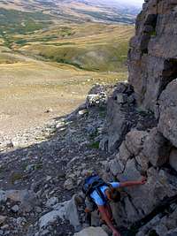 The most difficult climbing on the route. The most difficult climbing on the route. |  The view east from the slopes of Mad Wolf Mountain. The view east from the slopes of Mad Wolf Mountain. |
If you look at a map you will notice Mad Wolf has a eastern peak and a Northern Peak, along with the long ridge to the west that leads to Eagle Plume Mountain. There is an easy break in the band of cliffs that allows access to the talus slopes up to the saddle between Mad Wolf and its eastern peak. There are one or two easy class 3 stretches going through the break, class 2 the rest of the route. Once reaching the saddle head west (take a right) and it is only a short detour to climb to the summit of Mad Wolf Mountain. This is one of the great front range mountains where looking in one direction (west) all one sees is a sea of peaks and the other (east) is the start of the great plains. On clear days it is even possible to see the outline of the Sweet Grass Hills which are over 100 miles away.
 |
|---|
From the top of Mad Wolf looking west and you will see the distinct summit of Eagle Plume Mountain straight ahead. The LONG ridge walk leads all the way to this rather distant looking peak. The views along the 2.5 miles are incredible in every direction and the scenery seems to change with almost every step. There are no obstacles the entire 2.5 mile route which is a rare occurrence for a ridge walk in GNP, and makes this perhaps the most enjoyable walk in the park.

|
|---|
Once you reach the base of Eagle Plume Mountain follow scattered game trails as you climb. When the game trails stop climbing pick your way through the small cliffs and talus fields trying to avoid a few annoying patches of scree. Before you know it you will have gained the 800 vertical feet and be standing on top of Eagle Plume Mountain. The views are once again amazing in each direction with Mt Stimson looking particularly impressive.
From this point simply retrace your steps to your car or even better one of the wonderful campsites along the Cut Bank creek that you reserved before you left in the morning. I would recommend getting an early start on this climb because it is a full day and the most difficult route finding occurs at the beginning and end of the climb.
gbrill - Aug 12, 2014 10:09 pm - Voted 8/10
CoordinatesThe correct location for this mountain should be: 48.553025N -113.417601W Current coordinates has Eagle Plume Mountain located in southwest Montana.