-
 39818 Hits
-
 96.63% Score
-
 61 Votes
|
|
Mountain/Rock |
|---|---|
|
|
48.81441°N / 113.76017°W |
|
|
Mountaineering |
|
|
Summer |
|
|
9146 ft / 2788 m |
|
|
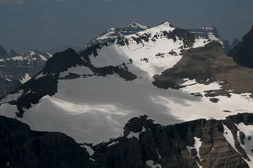
 This view's no slouch!
Overview
Iceberg Peak-- the name itself draws attention and stirs imagination. And it fits. From certain positions, Iceberg Peak does rise like a pinnacle above an ocean of mountains. Also like an iceberg, there is far more beneath that tip; in this case, about 3000’ of talus slopes and sheer cliffs guard the small summit of this beautiful peak.
Most people see Iceberg Peak from the shores of Iceberg Lake, which is known for the blocks of ice that float in its strikingly blue waters most of the summer and which is the actual source of the peak’s name. From Iceberg Lake, Iceberg Peak rises via sheer mountain walls more than 3100’ to its summit on the Continental Divide. Although many admire it, few climb it, for climbing it is an arduous task requiring a great deal of elevation gain, most of it off-trail, and, by some routes, skill on Class 3 and 4 rock and tolerance for exposure.
Considering that a step off Iceberg’s eastern edge would entail an unbroken fall of at least 2000’, the mountain would make a reliable method for those seeking to end their lives. However, experiencing the views from this summit might convince even the most desperate of souls that there still are things worth living for.
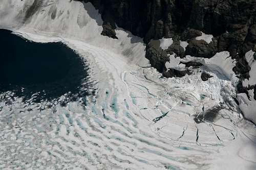
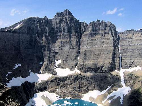
It would be impossible to list every noteworthy thing visible from Iceberg Peak’s summit, but what follows is a sampling of the many highlights. North: Ipasha Peak, Mount Merritt, Natoas Peak, and Chief Mountain. East: Mt. Henkel and Mt. Wilbur. South: Mt. Siyeh, Mt. Gould, Mt. Grinnell, and the peaks around Logan Pass. West: Heavens Peak and the Livingston Range. Several glaciers are visible, as are several lakes, including, of course, Iceberg Lake, almost straight down from the summit, and glacier-fed Helen Lake, farther away but more than 4100’ lower than Iceberg Peak’s summit.
While massive Mt. Wilbur, only about one air mile east, and Iceberg Lake may capture the most attention, there is so much to see from the top that it will be hard to believe and hard to leave. All that prevents the scene from being about as wild as a view possibly can be is the sight of the Many Glacier Hotel several miles to the east. That does not, however, ruin the view in any way. In a way, it makes it better for reminding the beholder how far from and how much higher above the civilized world s/he is.

 By saintgrizzly
Routes Overview
This section will summarize the three main routes on Iceberg Peak. Each is different and involved enough to warrant its own page, and there are now pages for all three. Detailed information for each route is also available in J. Gordon Edwards’s A Climber’s Guide to Glacier National Park, but his descriptions of complicated routes can be difficult to follow.
Iceberg Notch
This route is the shortest, most challenging, and probably most exciting one on the peak. The usual approach is from the Iceberg Lake Trail, leaving the trail shortly before the lake to climb steeply to Iceberg Notch, from which one climbs and traverses to the western side of the peak and then to the summit. RT distance is 12-13 miles, with an elevation gain of around 4300’. Expect Class 3 and 4 conditions and the possibility of steep snow.
This route can also be done in a day via Ahern Pass from Granite Park after starting at the Loop on Going-to-the-Sun Road, but that route entails around 5400’ of elevation gain and 20-21 miles RT.
Here is a video from a climb of Iceberg Notch, supplied by SP member jimegan.
 Iceberg Peak with Iceberg Notch to the right-- photo by saintgrizzly
Highline Trail
This is the easiest route in technical difficulty, but it is exhausting. It can be done in a day from the Loop, but it is better done combined with an overnight stay at the backcountry campground or the chalet in Granite Park. To reach Granite Park, one must hike almost 8 miles along the Highline Trail from Logan Pass (but the hike is easy, with little significant elevation change) or hike the Loop Trail, a more strenuous trail that gains about 2500’ in elevation over 4 miles.
This route leaves the Highline Trail 3.5-4 miles north of Granite Park and ascends talus and/or snow slopes to reach the western side of the peak, where it is a steep talus hike to the top, although climbers will likely encounter Class 3 and perhaps even Class 4 conditions (without bad exposure, though) unless they happen to find the climber’s trail up there (it is easier to find when descending). RT distance from Granite Park is around 10 miles, with around 3000’ of elevation gain in all.
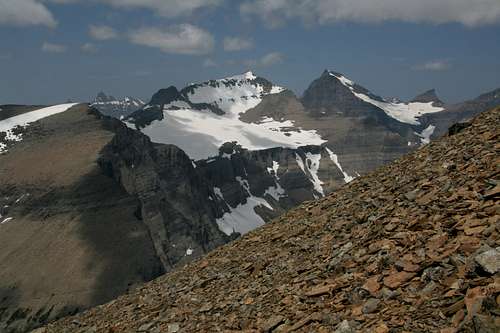 View from Highline Trail route
South Iceberg Peak
Officially, there is no South Iceberg Peak, but the route name refers to a summit on the Continental Divide south of Iceberg Peak, and the route crosses that peak. The route follows game trails along or just beneath the Divide, sometimes cutting through the cliffs from one side to the other, from the slopes of Swiftcurrent Mountain. From Granite Park, the route is around 10 miles RT with around 3200’ of elevation gain in all. Most of it is Class 2, but there will be scrambling sections that can be kept at Class 3 if care is taken. Views are spectacular all the way.
 View from South Iceberg Peak route
Getting There
Park at Logan Pass on Going-to-the-Sun Road if you wish to approach via the Highline Trail (arrive early). Park at the Loop, which is about 9 miles west of Logan Pass, to use the Loop Trail. If the parking lot you wish to use is full, consider parking at one of the shuttle bus stops and using that system (free) to reach the trailhead.
There is an alternate approach to Granite Park using the Highline Trail, and it is useful if you want to shave some distance or if the parking lot is full. The route is described in detail on pgs. 277-278 in the Edwards guide. In short: park a little above the Weeping Wall and look for a well-worn trail leading up the mountainside. Use the trail and streambeds to reach meadows above, where a trail leading to Haystack Butte and the Highline Trail can be found. The general route can be viewed well from the road. This route does incur more elevation gain than following the Highline Trail from Logan Pass does.
The trailhead for Iceberg Lake is at the end of the road leading into Many Glacier Valley, next to the Swiftcurrent Motor Inn.
Red Tape
It now costs $25 for a week's entry to the park.
This is prime grizzly country, so exercise due caution.
Camping and Lodging
If approaching from Granite Park, camp at the backcountry campground or stay in the Chalet there, where there are beds and generator-provided electricity (which means cold beer in the evenings). Both places will most likely require reservations. Although first-come, first-served campsites are available, it is unwise to count on getting one.
Backcountry camping Info
Chalet Info
If approaching from Many Glacier Valley, you could stay at the Many Glacier Hotel or the Swiftcurrent Motor Inn, or you could camp at the Many Glacier campground (no reservations, usually fills).
Lodging information
Select Summit Views