
-
 14013 Hits
-
 77.48% Score
-
 8 Votes
|
|
Mountain/Rock |
|---|---|
|
|
48.53553°N / 113.42428°W |
|
|
9377 ft / 2858 m |
|
|
Overview
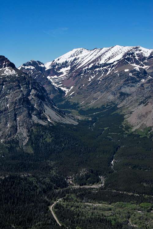
Scenic view of Red Mountain
Most visitors to the Two Medicine area of Glacier National Park will remember Rising Wolf Mountain. Its impressive false summit towers over 4,000 feet above Two Medicine Lake, and to say it dominates the landscape would be a gross understatement. Rising Wolf is so big that it keeps its equally spectacular neighbor Red Mountain, only slightly shorter and certainly less famous, hidden in relative obscurity.
At 9,377 feet, Red Mountain is one of the tallest peaks east of the Continental Divide in Glacier National Park. Sitting in Rising Wolf’s shadow, and curiously omitted from Gordon Edwards' exhaustive A Climber’s Guide to Glacier National Park, Red undoubtedly sees less climber traffic than the other sentinels of the east side. It is a massive hulk of rock. Its long red ridge stretches for several miles from east to west, straddling the divide between the beautiful Dry Fork Creek and Lost Creek drainages. Those that venture to the top will tell tales of interesting rock formations, enjoyable route finding, and inspiring views of glaciers, deep blue lakes and the Great Plains stretching out to nowhere and everywhere to the east. With a rainbow of sedimentary rock colors comprising Glacier’s crumbly peaks, there are many red mountains… but there is only one Red Mountain.
Getting There
Red Mountain is most easily accessed from the trailhead at the Two Medicine car campground. A paved, 7.5 mile long road provides the only vehicle access into Two Medicine. The road is quite bumpy in spots, and I have seen bear from the car many times over the years, so it’s best to take it slow and enjoy the drive! The Two Medicine Entrance Road starts 4 miles north of the small village of East Glacier Park and intersects with another rugged road, The Looking Glass Highway (MT-49).
Two Medicine can also be accessed via a series of well-maintained trails. Two long, remote backpacking trails lead up Park Creek and Nyack Creek and over windswept passes (Two Medicine and Cut Bank, respectively) from starting points south along US-2. More popular trails originate in the St. Mary and Cut Bank areas to the north and lead over spectacular Pitamakan Pass and down to Two Medicine. There is even a trail from East Glacier Park; note that this trail crosses the Blackfeet Indian Reservation and a conservation permit ($10 annually, available at local establishments in nearby East Glacier) is required for by each person recreating on Blackfeet land.
Route
There are two practical approaches to Red Mountain. Both originate from the trail that climbs up the Dry Fork Creek drainage to Oldman Lake and on to Pitamakan Pass. I have read brief accounts of parties climbing Red directly from the pass; it certainly looks possible to scramble along the long southwest ridge that leads from the pass towards the summit. If anyone has any route information from the pass, please feel free to add it under this page's comments section! My group utilized the great south slope as we planned to visit the large unnamed tarn that sits around 7,000 feet above sea level at the southern base of the mountain. This route is detailed below.
South Slope Route
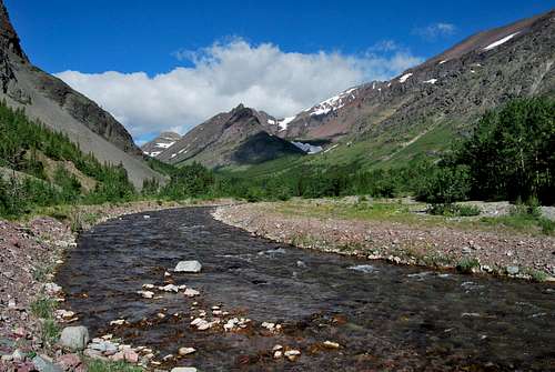
Take the trail from the Two Medicine Campground, immediately crossing the outlet of Pray Like on a steel bridge. Just across the bridge, the trail splits; hang right to hike towards Oldman Lake and Pitamakan Pass. The trail wraps around Rising Wolf Mountain for 2 miles before descending slightly to a plank bridge crossing of Dry Fork Creek. The creek bed is very open here, and one can appreciate the immense size of Red Mountain as it stretches out far to the west.
Dry Fork Creek crossing. Red Mountain's broad summit is just above and to the right of center.
Cross the bridge and continue on the Pitamakan Pass trail as it forks to the left. The trail gently climbs through a forest for a few minutes until opening up considerably, with open grassy terrain emerging on the hiker’s right. Choose the most practical spot to leave the trail and take advantage of moderate slope and good footing as you begin to make an ascending traverse to the northwest. Eventually, a seasonal drainage must be carefully negotiated; if you encounter difficulties finding a safe place to cross, be patient and look for low class III options that provide access to easier terrain. Soon the drainage that tumbles down from the unnamed tarn south of Red Mountain will come in view far below and to the left, and an obvious route leads beneath (to the left of) a rocky shoulder with steep cliffs. A classic Glacier red scree field must be crossed, but sparse game trails will help ease travel across the loose rock.
 |  |
|---|
After rounding the rocky shoulder, the unnamed tarn comes into view and more of the south slope is evident. Begin to work upward, initially trending slightly to the east (right) if large, unclimbable cliffs are encountered. A series of scree/talus fields and class II and III ledges allow for a wide variety of routes up the south slope. Refrain from straying left until gaining at least 1,000 feet of elevation from the unnamed tarn; the goal is to utilize easier terrain farther east as you climb towards the ridgetop.
 |  |
|---|
The scree-covered ramp.
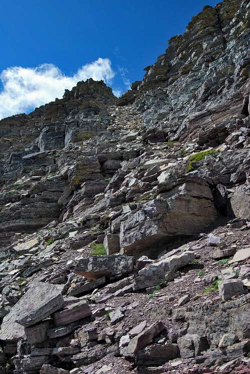
If one were to continue climbing straight upwards, impassable cliffs that comprise the crumbly ridgetop would eventually be encountered. As elevation is gained, scan the slopes that leads toward the summit farther to the west. Just east (right) of the summit block, the ridgetop dips into a very noticeable notch. It is imperative that this notch be gained, as it provides the only safe passage to the summit from this approach. Careful observers will notice a distinct scree-covered ramp that angels towards the notch; this class II ramp affords solid footing and allows for a rapid ascent of the last couple hundred vertical feet to the notch.
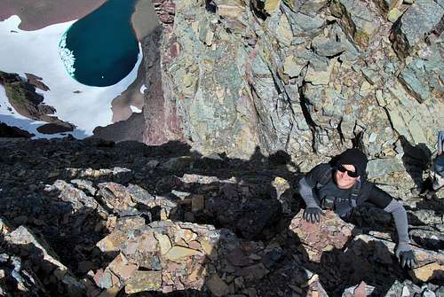
Red Mountain Notch
Views from the notch are spellbinding. To the north, Running Crane Lake appears but a stone’s throw away some 2,000 feet below. From the notch, one partially exposed move with good handholds leads to a broad ledge and a few easy scree ledges before topping out on a flat ridge. The summit block is a bit farther to the west, and is obtained by a short, easy class III scramble. As one might expect, monstrous Rising Wolf Mountain, directly across the valley to the south, obstructs views of much of Two Medicine, but views in all other directions are absolutely amazing. Far to the west, Pumpelly Glacier glistens on the flanks of Blackfoot Mountain. Views to the southwest are dominated by the towering presence of Mount Stimson, second tallest peak in all of Glacier National Park. The view north goes on for what seems like forever, all the way to Chief Mountain just south of the Alberta border. And on a clear day the Sweet Grass Hills, anomalies rising over 3,000 feet above the stark Great Plains, are visible approximately 100 miles to the east.
Return via the route of ascent, taking care to locate and carefully down climb to the notch. Multiple route options exist on the descent, and nothing worse than Class III need be negotiated. Plan for a full day on the mountain. Our party of strong hikers took over 10 hours car-to-car on a sunny, gorgeous July day.
When to Climb
Due to extreme winters along the Continental Divide, problematic snow can linger on trails and mountain slopes well into July and August. Hence, the prime climbing season in Glacier is rather short, often beginning in June and lasting into late September/early October. However, some lower peaks and south facing slopes can be safely attempted much earlier in the season. Your best best is to inquire locally about snowpack and weather conditions. Personally, I have found the NOAA website to be the most reliable resource for detailed weather forecasts and snowpack information for the greater Glacier area.
High angle snow fields linger on the south slopes of Red Mountain well into July. Competent route finders could likely detour along and around the snow, but it’s possible that snow would be encountered near the notch earlier in the season. Parties climbing in June should definitely be equipped with ice axes in case snow crossings cannot be avoided.
Where to Stay

Sinopah Mountain reflects in Pray Lake near the Two Medicine Campground.
For a quieter, more rustic camping experience, consider the campground at Cut Bank farther to the north. Accessed via a well-maintained 5 mile long gravel road from US-89, Cut Bank offers 15 sites with no electric hookups or potable water. The meadows near the campground and nearby Cut Bank Creek are truly wonderful areas to enjoy! Information on historic campground fill times, reservations and camping regulations can be found on the NPS camping webpage.
East Glacier Park has an array of private campgrounds, historic lodges (including Glacier Park Lodge, which turned 100 years old in 2013!!!) and family owned motels and cabins. The town is quaint, but gas, groceries and good restaurants are all available.
Red Tape, Wildlife, etc.
Entrance Fees
A fee is required for all persons entering Glacier National Park. As of November 2016, single vehicle rates are $30 for a seven day pass, or $45 for an annual park pass (increasing to $50 in January 2017). A lower fee is charged for hikers and bikers; please visit the NPS fees webpage for a full explanation of the entrance fees.
Seasonal Closures
Glacier is subject to extreme winter weather conditions, and as such, much of the park is virtually inaccessible for the majority of the year. The Going-to-the-Sun Road is typically open in its entirety from mid-June to mid-September, and many of the developed areas of the park (including the historic lodges and most of the campgrounds) operate for a short window as well. Information on the operational status of front country campgrounds and park roads can be found by clicking on the hyperlinks.
Glacier Rock Grading
Due to the sedimentary nature of the rock in Glacier National Park, unique rock grading systems have been established by both Gordon Edwards and the Glacier Mountaineering Society. Please refer to the Glacier National Park Rock & Grading Systems Summitpost page (authored by Fred Spicker and Saintgrizzly) or the website of the Glacier Mountaineering Society for detailed information. If you are new to climbing in Glacier, I highly recommend checking out this info before attempting any climbs in the park. Oh, and don't forget to wear your climbing helmet!A Climber's Guide to Glacier National Park
Pick up a copy of Gordon Edwards classic' A Climber's Guide to Glacier National Park. It's an absolute must for anyone who wants to safely venture to one of the park's many accessible mountain summits. Edwards spent many years as a seasonal ranger in Glacier, where he developed a deep passion for exploring the park's mountains and sharing its splendors with others. The book provides a fantastic history of climbing in Glacier, and his detailed and colorful route descriptions are a fantastic introduction to off-trail hiking and climbing in the park.
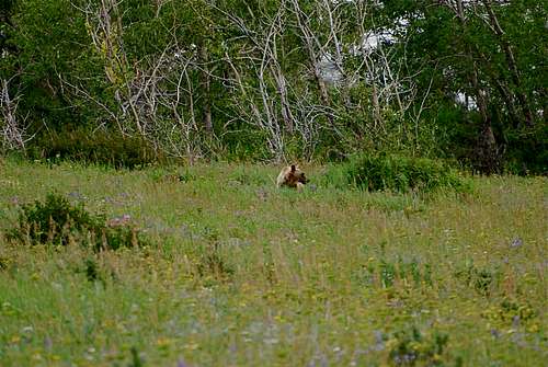
Hey bear!!!
The park is home to lots of potentially dangerous wildlife, including moose, black bear, grizzly bear, and mountain lion. Hike loud, carry bear deterrent spray (and know how to use it!), check local trail postings (for area warnings/closures) and let someone know your intinerary before heading out into the park. Also, note that special precautions are in place in all front and back country campgrounds to limit human-bear encounters. Regulations are posted everywhere (picnic tables, ranger stations, bathrooms) and it is every visitor's responsibility to take them seriously. Remember, a FED BEAR IS A DEAD BEAR! Please visit the NPS camping webpage for more detailed information.
Special Thanks
Special thanks to Rebecca Lahr, Josh Olson, Julia Taylor, Rory Kuykendall and Sean Doyle for spending 10+ incredible hours on a beautiful July day exploring this amazing peak!Parting Shots
A couple different views of Red Mountain captured around the east side of Glacier National Park. |  |  |
|---|