Idaho has nine summits that reach over 12,000 feet and all but two lie within the Lost River Range in central Idaho. Idaho’s tallest and most visited peak, Mt Borah (12,662’), is located in the central section of the range. As the state highpoint, it is also very popular. During the summer months, it is not unusual to see a full parking lot and 50 or more people attempting to climb the mountain by its most popular route, the Southwest Ridge, or “Chicken-Out-Ridge” as it is more commonly known. For some classic snow or ice climbing, Borah also offers several hidden gems on its North Face that have been documented here. In spite of all of the traffic the mountain has seen, the remote East Face remained relatively unexplored until the summer of 2011.
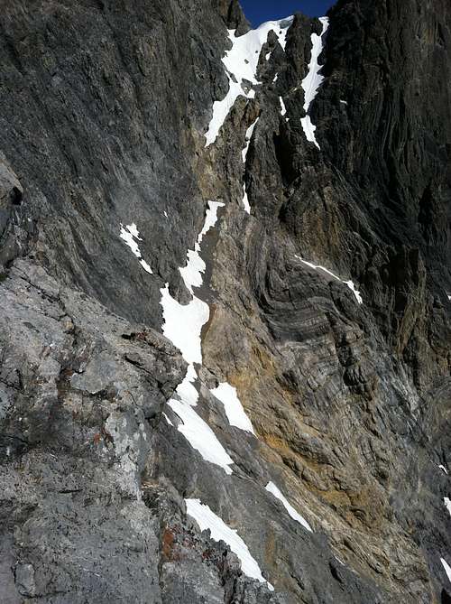
Idaho’s Lost River Range is an actively uplifting fault-block at the northern end of the Basin and Range province. Extensional faulting has lifted the range relative to the down-dropped Big Lost River basin on its west side, producing steep ridges and slopes essentially devoid of foothills. Interior and eastern regions of the range are deeply incised by the Pahsimeroi and Little Lost Rivers. Most of the range, particularly in the central and southern regions, consists of thick layers of Paleozoic limestone and dolomite. Multiple episodes of tectonic deformation have resulted in dramatic open to isoclinal folding at a scale of meters to kilometers. Glaciation has carved numerous cirques throughout the range and alpine lake basins are scattered in the central and eastern portions. These combined activities have created an impressive assortment of large, high angled faces with western, northern, and eastern aspects. (Frank Florence - 2014)
Background
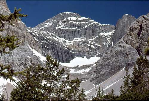
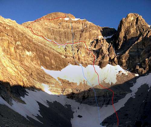
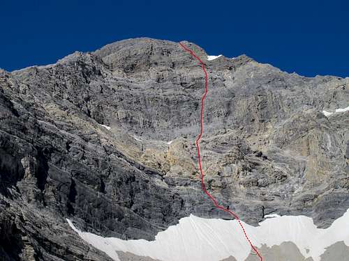
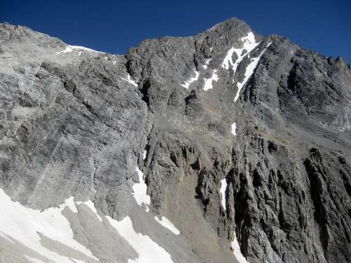
![East Face of Mt Borah]() East Face of Mt Borah 1977
East Face of Mt Borah 1977
I first visited the eastern side of the Lost River Range (The Pahsimeroi Valley) in 1972, while working on a helicopter contract for the Forest Service. Flying through the range provided me a view that few ever get to see. While all of the range is impressive from the eastern side, one face stood out from the others. When our contract with the USFS finished at the end of summer, I took a break from the 24/7 aviation life I was accustomed to. During this down-time, I happened to notice an ad for an introductory rock climbing class and thought, “Wow. Cool. Ropes and everything, I’m game for this!” I talked a couple of friends into joining me for the class. After completing our class, we were ready to test our newly learned skills on a real mountain but winter soon arrived and we put our plans aside until the next summer.
Summer came late in 1973. It wasn’t until the end of June that we were able to get in for a closer look at the East Face. As the morning sun warmed the snow high in the cirque, we watched slide after slide tear loose and nail virtually every approach to the mountain. Along with the snow slides came a lot of rock fall as well. After sitting and studying the face, it looked to be climbable. There was no doubt, however, that the attempt would have to be made during the dry season. In 1974 we returned for another exploratory trip and picked out a line on the face that followed some water streaks in a nearly straight path to the summit. We decided that this was the route we would attempt on our next visit.
A couple of years passed. In trying to sell potential climbing partners, I described this face as “Idaho’s Eiger” but at the time, the range had no technical rock routes. Idaho has so much fine granite it was hard to justify a trip to the Lost Rivers, where the limestone rock had a reputation for being nothing but choss. In the fall of 1975, Mike Weber and I decided to throw caution to the wind and give this face a serious attempt. We loaded up all of the gear we thought we’d need and made the brutal drive to the end of the road up the West Fork of the Pahsimeroi River. Hiking through open sagebrush, we made quick work of the approach and found a nice grass-covered spot for our camp at the lower tarn just above timberline. Curious to see the face up close, we grabbed our crampons and axes and headed up the snow and ice to where the bare rock began. Just as we were approaching the final section of snow and the start of our proposed route, we heard a rumble from above, freezing us in our tracks. A Volkswagen-sized rock was flip-flopping down the face. Within seconds, it reached terminal velocity bouncing back and forth down the face. We stood motionless in our stances trying to figure out if we should go left, right, or just clasp our hands and pray. Fortunately, the rock deflected about 40 feet to our right. We just stood there watching it tear up snow and bounce to the flats and the tarn at the bottom of the cirque. We tried to convince each other that the face would be frozen up by morning but neither of us was to be convinced. Around 2:00 am we were startled awake by a blinding flash of light and milliseconds later, a rumble of thunder. We both knew our chances to climb were most likely over, so we pretended to go back to sleep. Within minutes, the rain was falling at a rate of an inch or two an hour, and shortly afterward our campsite became a flood zone. We stayed in the tent until it was surrounded by flowing water, our cue to get the hell out of there.
For decades after that ill-fated attempt, my climbing partners and I continued to explore and put up routes in the range. Despite those many visits, we never made it back to the cirque. I pretty much wrote off the East Face as being a very dangerous place and that kind of risk no longer appealed to me. Also, as time progressed, I gained the impression that sport climbing and bolted routes on established climbs were the “new norm” and the pioneering of new alpine routes seemed to have gone by the wayside. It wasn’t until the spring of 2011, during a discussion of Lost River climbs on the Idaho Summits web forum, that a new spark of interest began. When I first described the East Face cirque, most local climbers did not know what I was talking about. This, despite most of them having climbed Mt Borah multiple times. One did, though. After reading my description of the face, Wes Collins, a local climber and native of the area, immediately became interested. Soon, a new discussion started about taking a trip to the cirque.
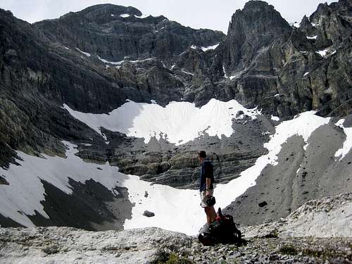
The Dirty Traverse Grade III 5.4
![The Dirty Traverse]() The Dirty Traverse The Dirty Traverse |
![The Dirty Traverse]() Wes on the approach Wes on the approach |
![The Dirty Traverse]() Looking across the traverse Looking across the traverse |
![The Dirty Traverse]() Dirty Traverse (red) Route Photo Dirty Traverse (red) Route Photo |
Wes couldn’t wait to see the face up close so he took off on an exploratory trip with his wife and dog. This trip in 2011 started as a recon, but Wes found himself drawn to the face like steel to a magnet. The following is Wes’ account of the first ascent.
Bob got me all fired up to get a look at the eastern cirque and what he described as Idaho’s Eiger. I certainly wasn’t disappointed. Susan and I planned the trip as a leisurely backpack into Lake 10,204 to take in the views, but I tossed an axe and some light crampons in the truck just in case.
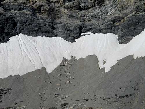
I spent a lot of time looking at the face before I even thought about a spot for the tent. Stupidly, I’d left my axe and spikes in the truck, but at this point I knew I was going to make a serious try for the summit. It didn’t take long to pick out a couple possibilities, but the most probable line would involve a long traverse across a talus-covered ledge on the lower face. I started thinking of the route as the Dirty Traverse before I even put my boots on it. Morning was an easy laid-back affair. We sipped coffee and we watched the sun line slowly make its way down the mountain. I had to wait until nearly 10:00 before the snow softened enough for step kicking. The first, lower snowfield was pretty firm, but the second was much softer.
I’d found a nice tooth-shaped chunk of limestone that probably wouldn’t have done much more than keep my feet down hill if I took a fall. I was on my own, but it was still embarrassing to have the damn thing in my hand and I had to keep fighting the urge to hide it in my pocket. At the top of the snow, the randkluft was several meters deep and the first tentative moves on rock over the blackness below felt pretty exposed. The rock, however, was surprisingly solid and clean.
The scramble to the traverse ledge was fairly sustained Class 4, but the rock was good enough to make me forget about the exposure and enjoy the ride. The traverse ledge was quite tedious though and I wasn’t sure it would go all the way to the ridge until I got there.
Once on the ridge I made my way up an easy Class 5 seventy foot buttress but it could have been easily bypassed by scrambling around its west side. Most of the ridge above the traverse is Class 3 or easier.
As I continued up the ridge, my doubts got bigger. The entire north side of the East Ridge is very tall and overhung in several places. More and more I suspected it would dead-end into the headwall but at the last possible minute, a tiny col opened up onto the uppermost ledge that crosses the East Face. It wasn’t till that moment that I knew the ridge would go all the way. Splattski summed it up nicely in his trip report of JT peak as the almost magical opening of doors as you climb. This was one of the most fun parts of this outing. I couldn’t agree more.
The descent follows the standard route down the mountain to the big saddle at 11,800. From there, I dropped into the cirque that takes in the south side of Borah and Mt. Sacajawea. There are several sections of Class 3/4 scrambling over short but loose cliff bands and several linkable snowfields, but the glissade run-out potential is pretty dangerous on most of the snowfields. At the 10,400 contour the angle eases up. From there I hiked down and around the bottom of the East Ridge and finally back up to camp.
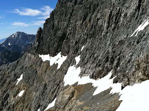
The East Face Direct III 5.9
![East Face Cirque]() Kevin and Wes in the cirque Kevin and Wes in the cirque |
![East Face Direct]() East Face Direct East Face Direct |
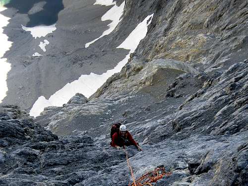
![East Face Direct]() Wes high up on the East Face Wes high up on the East Face |
![East Face Direct - Route Photo]() East Face Direct - Route Photo East Face Direct - Route Photo |
On September 23rd Bob Boyles, me, and Kevin made the bumpy ride to the end of the West Fork road and set up camp with the intention of putting up a Direct Route from the lake to the summit on the following day. The weather that weekend was perfect for a serious shot at the face. Bob kept the monotony in camp to a minimum with his tales of Lost River Range epics. Bob and I stayed up till well after midnight swapping stories and swilling beverages. In the morning we sorted gear and then re-sorted as soon as we tried to stuff it all in our packs.
Bob had previously decided to stay at lake 10,204 and soak up the views. He was able to watch and photograph our progress throughout the day. From the far side of the lake, we ascended the first snow patch and cliffs to the base of the second and much more steep-snow field. We laced on crampons and quickly made our way up to the randkluft. It was a short hop to the base of the 2,000-foot wall. A jump from snow to rock in crampons is always a tricky affair but we both managed it without ending the trip at the bottom of the crevasse.
Kevin brought an 80-meter rope that was both a blessing and a burden. After climbing 80 meters the rope drag can add a lot of gravity. I led the first two pitches and much of the climbing was done with a running belay. By the time we reached the dirty traverse ledge I was happy to give up the sharp end for a bit. Kevin started up a steep bolder section at the beginning of pitch 3 and managed to plug a number 4 Friend (the only big piece we had) into the back of a large detached flake. The rest of the gear was small wired nuts and very small cams. Although gear options were pretty plentiful we placed very few pieces on the entire face. The holds were more than adequate and for Borah, the rock quality was superb. When Kevin ran out of rope he set up a hanging belay as the sun was beginning to set behind the face. I looked at my watch and realized it was already 2:20pm. As Kevin was making ready to belay me up I heard a large (toaster sized) rock slam into the face about 500' above us. It bounced off the face and hit again about 100 feet lower and then started a long 400' spinning free fall. The dark sound of a falling chunk of limestone is hard to describe but it reminded me of an old Road Runner cartoon. I tried like hell to get a fix on it but the sun was in the worst possible spot. In the last moment I attempted to shrug my shoulders up under my helmet and squeezed into the wall. I heard it hit the ledge 20 feet to my left and then watched it bounce off into space. Smaller pieces of shrapnel continued to rattle down behind it so I didn't get to see if it went all the way to the lake.
On Pitch 4 I spotted a green backpack full of wet clothing wedged into a tight chimney left of our route. I set up a belay under a small roof and as Kevin followed he climbed over and retrieved it. He brought it up to the ledge and we used a wired nut to attach it to the face. Kevin looked at the beginning moves on pitch 5 and said, "This one is all mine" He'd been waiting for something to really challenge his rock skills and this section gave him what he came for. He quickly made his way up over the roof and onto a dirty ramp with nothing but friction holds. Several rocks spilled down in his wake and I was thankful to be under the roof. Near the top I heard him talking to himself and knew he was battling the fear of falling. This was easily the toughest pitch on the face and while following it I was grateful I hadn't been the one to lead it. Kevin was able to place two good pieces up to the half way point and another not so good piece below a crumbling 20 foot bulge near the top. A fall would have sent him on a 40' tumble and much further if his third piece would have pulled. At the Pitch 5 ledge we made a decision to save time by making an unroped dash to the summit. We cruised up an easy class 5 ledge and then fought our way up deep, sliding scree to the top of the upper traverse ledge. From there a class 3 scramble put us directly on the summit.
East Face - Northeast Ridge Variation III 5.6 WI2
![East Face/NE Ridge]() Decisions, decisions... Decisions, decisions... |
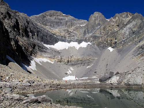
![East Face Cirque]() Below the cirque Below the cirque |
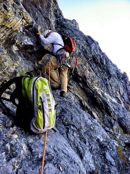
![East Face of Mt Borah]() Frank on the approach Frank on the approach |
![East Face of Mt Borah]() East Face of Mt Borah East Face of Mt Borah |
![East Face Exit to the NE Ridge]() East Face Exit to the NE Ridge East Face Exit to the NE Ridge |
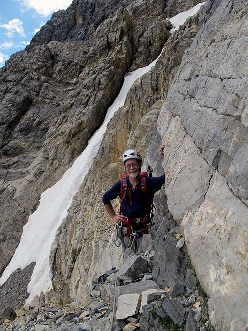
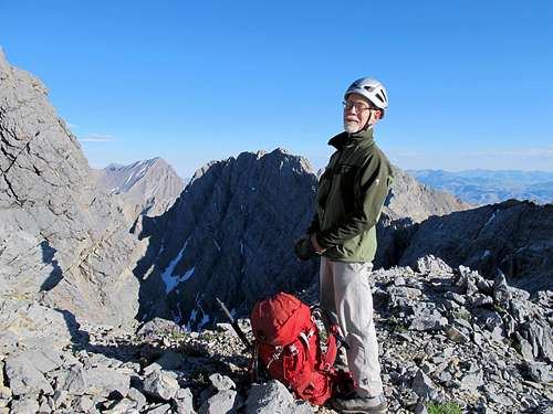
Fourty years had passed since I got my first glimpse of this stunning face in the summer of 1972. Marriage, children, three careers, aging parents and all the other distractions of life had occupied my free time and desires for much of this time. I never forgot about the East Face but simply put it in the back of my mind and figured I would never get another shot at this, and so be it. Like me, my climbing partners of the time moved on to other priorities in life and while most of them still climb, it seemed nearly impossible to raise the kind of enthusiasm again until I stumbled on to our local outdoors forum and found just the spark I needed to give it another go. I had accompanied Kevin and Wes on their ascent of the Direct East Face during late summer of 2011 but opted to not climb on that trip. Those two were more than eager to get back into the range the next summer so getting them pumped up about another trip was no problem at all. If I could find one other person who was interested we could go as two teams of two which is a good number considering how long the routes are in this range. I had been corresponding with my lifelong friend, Frank (and climbing instructor in 1972) and he happened to be both free and very interested in getting back to the Lost River range again. The plans were made and soon after the four of us were bouncing up the road on another trip into the West Fork of the Pahsimeroi River. We began discussing our plans for the next morning and it didn't take long for Kevin to tell us that he had his sights set on a new route on the North Face of Sacajawea, one drainage to the south of Mt Borah. He and Wes were going after Sac and Frank and I could take a shot at the east side of Borah. Frank and I had three different routes to consider, one of the two east ridges or a variation on the face that would link up with the Northeast Ridge. I thought about this for a few seconds and quickly decided that I had to lay my hands on the face that I had been denied decades ago.
On the morning of the 25th, we all set out a little after 6:00 am. The two mountains share the same ridge so we hiked together for the first mile and then went our separate ways where the ridge ends in a wide park at 8,900’. Wes had brought a pair of two-way radios and although I had doubts they would work very well in this range, surprisingly, we had good reception throughout the day. Frank and I made fairly quick work of the short but steep approach to the snowfield at the bottom of the face. I topped out on the snowfield first and noticed there was a six foot gap between the snow and rock. When I peered over the lip I could see that I was on the edge of fifty foot angled, icy crevasse that pinched shut at the bottom. About six feet down in the ice filled gap I noticed a ledge so I carefully straddled the lip and hopped on to the ledge. Frank was a short ways behind me and was a bit bewildered when I first disappeared over the edge. A few minutes later I saw two hands appear above me on the sharp icy edge of the rand and then his face with a big smile. We made the switch from snow to rock gear and Frank took off into the unknown. The rock was amazingly sound with the exception of rubble piles on every ledge. The first three pitches flew by as Frank ran out a full 60 meters of rope with only one or two pieces of pro per pitch. Around P4 the rock started to steepen and for a few minutes we were stymied until Frank found a way over a bulge that required a few 5.6 moves to get up. Frank quickly moved out of sight and the rope ran continuously through my belay device until I heard the word "rock". I peeked out of my shallow stance and saw a handful of small rocks rattling down the steep ramp straight towards me so I tucked in and held on tight. One hit me in the arm and few seconds later one bounced off my leg but they were small and didn't have time to generate much velocity. I brushed this off as just part of the price of admission on this climb and didn't think about it again. Frank yelled out "are you okay" and I laughed and said "no harm done". I followed the lead and joined Frank at the next belay stance and he took off again into the unknown.
I had carried my camera around my neck with the intention to photograph every pitch of this climb but the crux pitch was steep and I didn't want to bang-up my $500 Canon so I put it in the top of my pack for protection. I thought about this as Frank was running out P5 when suddenly I heard a loud boom from above. A large rock had come off from the vicinity of the summit and when it hit one of rubble ledges a thousand feet or more above us it dislodged a barrage of smaller rocks and soon became a rock avalanche. We were a couple hundred yards to the right of the rockfall and this was the first peep we had heard out of the face all day so I didn't get too worked up about it at the moment. There was a snowfield directly above us that had been in direct sunlight since sunrise but this rock didn't come from that angle so I was a bit puzzled at first. I also noticed that much of the shrapnel had landed exactly where we had started a few hours earlier. I was tied in tight and on belay so I didn't have many choices about moving when I heard another rock dislodge and once again all I could do was stand there and watch the show. At this point my adrenaline came into full effect and I was getting a bit rattled. The rockfall was exciting as all hell as long as we didn't get killed but that really wasn't part of our game plan. Around 60 seconds passed and then another barrage came banging and exploding down the face. I knew exactly what was going at this point. The natural amphitheater the cirque forms magnifies sounds like no where else I have ever been and there wasn't a breath of wind to cover the sound. As soon as I heard voices from near the summit I knew exactly what was going on and I became livid. Some dumb asses were throwing rocks off the east face. This continued for around 10 minutes in sixty second intervals and from the last barrage one bowling ball sized rock deflected and was headed straight towards me. I stood there frozen in place watching the trajectory thinking, "well this is how it's all going to end" when the arc fell short and it hit about 50 feet shy of my stance. The rock took another huge bounce and went flying out of sight making that unearthly "vrrrrrrr" sound before it exploded below me. A minute or two later I heard Frank call out "on belay" and up I went in what was now survival mode. I completely forgot about my camera and climbed so fast I had to stop and catch my breath at times. For the rest of our climb not a single rock came off the face so I knew without a doubt what had caused the rockfall. Later, I was really bummed out that I had not shot video of the rockfall because I knew what I had witnessed would have been a instant hit on YouTube.
We took a short break somewhere around P6 and I heard Wes on the radio. He and Kevin had heard the rockfall from the Sacajawea cirque over a mile away and they were wondering what the heck was going on. We told them everything was fine and continued up to the Dirty Traverse ledge but not before donning our crampons and axes to climb another short, but steep snowfield. When we gained the Dirty Traverse ledge it still wasn't clear that we could connect the face to the NE Ridge. There appeared to be a large gap between the East Face and what we call the "Super Buttress" that was hidden by a rise in the ledge. It wasn't until I gained the high end before I could tell that this route was a go. Once I got to the top I could see that we had a continuous ramp that led to a very steep snowfield that terminates on familiar ground of the Northeast Ridge.
We took another short break below the start of the technical climbing on the NE Ridge and chatted with Wes and Kevin on the radio again. They were around 7 pitches up on the North Face of Sacajawea and everything was going fine for both of our teams. Frank went a short distance up the Northeast Ridge and then came back down to tell me that it was time to pull out the crampons and axes again. The steep, narrow chimney at the start of the ridge was full of hard water ice. We geared up accordingly and Frank disappeared up the steep step. When my turn came I saw the ice and got a big smile on my face. I was thinking "this climb is throwing a little bit of everything at us" and I'm enjoying (almost) every second of it. When I joined Frank at the top of the pitch we could see the summit pyramid about 500 feet above us and figured another hour or so and we'd be standing on the top of Mt Borah.
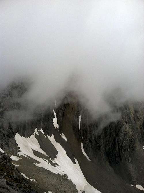
We scrambled and simu-climbed the easy ground between us and the summit pyramid only to see that there was some manky looking snow in the summit couloir and what I call the "V" notch that leads directly to the summit. Both finishes looked totally out of condition so Frank decided to take a line up the rock slightly to the right of the main couloir. I was starting to feel a little cocky about our new route and figured we had it in the bag when I suddenly a cloud blew over the Northwest Ridge some 500 feet below us. In minutes we were in a white-out and a cold rain was pouring down the rock. A few minutes later it turned to snow and before we finished the last two pitches the cloud blew over and the sky was bright blue again. Shortly after reaching the summit I got another call from Wes telling me that they were standing on top of Sacajawea. I grabbed my camera and zoomed in and sure enough, there they were. We had reached our summits within minutes of each other. We descended the South Face of Mt Borah into the Sacajawea cirque and made it back to our camp at midnight, 18 hours after leaving camp.
![East Face of Mt Borah]() Taking a licking Taking a licking |
![Sacajawea Peak]() Wes and Kevin on the summit of Sacajawea Wes and Kevin on the summit of Sacajawea |
![East Face of Mt Borah]() Frank at the start of our descent Frank at the start of our descent |
![Mt Borah's South Face]() Mt Borah's South Face Mt Borah's South Face |


Comments
Post a Comment