Just trying to get to Borah (7-15 & 7-16-06)
I left for my attempt on Borah Peak, ID on 7-15-06 after working that night and
attempting to change my oil before leaving. This was an impossible task, so I drove to Idaho Falls, by way of I-15. Upon arriving at 2AM, I found that all the oil changing facilites were closed on Sundays! So I slept in the Super Wal-Mart Parking lot because their Service Dept. opened at 9AM. At 9AM on the 16th, Wal-Mart opened and I waited like 45 minutes till they informed me that the bolt was stripped and refused to change my oil after all!! Well I decided engine or no engine, I was going to Borah.
I drove the 70 or so miles to Arco, ID; and decided I was hungry. I stopped at a restaurant named Pickles, and ordered the Steak and Eggs, because I knew good food was going to be out or the question on this trip.(Ummmm...Freeze-Dried!)
After Breakfast I began the drive to Mackay and Borah Peak, Finally! It was already about noon. However, my trip was delayed again when realized that I did not get ANY water for the trip to Borah, when I was passing through Mackay! Dammit!! With luck, I drove to the nearby Fish Hatchery, and was allowed to fill my hydration bladder! (If you guys from the fish hatchery read this, thank you!)
I took off again, water in hand and attempted to get to the Borah Trailhead. This somehow I screwed up and ended up about 2 miles past the turnoff.
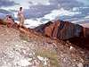
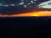
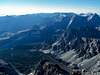
![Looking NE into Borah Pk.]() Looking into Borah showing route
Looking into Borah showing route Turning around again, I realized my GAS light was on, I couldn't have cared less. I finally arrived at the Borah Parking area, and was suprised to see about 15 vehicles already there!
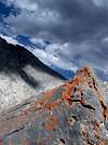
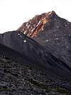
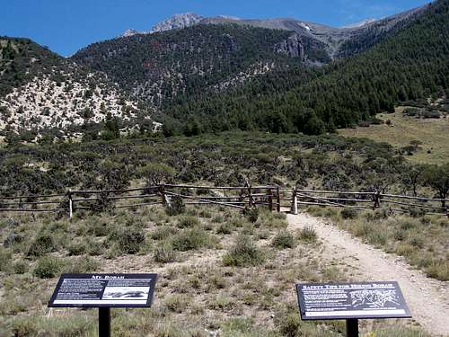
![Looking North into Borah Pk.]() Borah, showing western face
Borah, showing western faceStarting the Climb (7-16-06)
After Parking and chatting with a woman who was waiting for her husband to return, I was getting prepared for the trip, and decided that there was no need for my ice axe. (this is a decision that I later regretted). I began the trek, and made it about the first 1/2 mile before the "actual" climb began. The steepness of the switchbacks made them not really switchbacks, but rather more or less "S" curves up the incredibly steep face, while still in the tree line. The scree in the area, and the weight of my pack made this climb extremely difficult. This is about where I began to miss my ice axe. I passed many nice individuals on the way up who were able to offer advise about the conditions on the climb they had just endured.
Once above the tree line, I continued for about another half mile up the trail till a came to an area that seemed flat enough and large enough to make camp.
(I passed a total of three "bivy" areas along the trail above the tree line, the last being the largest). I had camp set up by about 5:30, about 2-3 hours after I left my vehicle. I began taking pictures, and cooking some nice freeze-dried chicken and mashed potatoes....UMMMMM!
About 8 o'clock or so, one final group passed on their way down, for they had intended a dark finish to their vehicles. I watched as the sun went down over the Sawtooth's from the vestibule of my tent, as I laid down for was I was intending on waking early and attempting the summit.
Damn Alarm Clock and Borah's Summit (7-17-06)
Well, instead of waking up at 4:30 AM, I was awoken instead by 6AM, and angered that the alarm had not gone off. I quickly packed, but as I later learned, a little too quickly. I quickly began the climb about 6:10 AM, and reached Chicken Out Ridge by about 6:45 AM. I shot a few pictures of the rising sun on the area and continued up C.O.R.
This I discoved was harder than I thought since there was no real "trail" or path up C.O.R. I decided to create my own route, and reached the snowshelf shortly after.
The snowshelf was hard snow, with a set of prints to follow. With the early morning sun, the footprints were iced over, making the crossing a little hairy. I continued past the snowshelf to a longer saddle, before attempting the summit itself.
I again lost the main route, and actually climbed up the face of Borah itself, which was far tougher; because it was large scree, and I did take a few heart-pumping slides for a few feet down this face. I finally made it to the SUMMIT! I knew instantly because I was finally able to see the sunrise reach the rocks on the top, and feel the warmth of the day.
I had reached the summit at 8:10 AM, and and began taking pictures and enjoying myself.
Getting Down and Getting Home
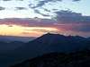
Well, its never really a successful summit if you are unable to get back down. So before taking off, I took several pictures of the surrounding area.The views from the top of Borah are spectacular! It offers views of not only the Lost River Range, But also the Lemhi, and Sawtooth Mountain Ranges. I had the summit to myself for a
full 45 minutes before I decided to begin my decent down the ridgeline.
I began by scaling down near the ridge, which was much easier than the accent route I used, but none the less, the loose rock made decent somewhat challenging. I peered over the ridge a few times, and saw the Eastern side's sheer edges, which dropped for several hundred feet. Once I reached the large saddle before the snowshelf and C.O.R. I met my first few climbers making their accent. They had started in the parking area about 3 1/2 hours earlier, and had about 30+ minutes of climbing ahead of them. After returning to my tent and breaking down my camp, I saw many more climbers on their way up to the summit as well. After a quick snack to cut more weight, I began decent at about 11 AM.
One thing I must say about Borah Peak is that in my opinion,
The Climb Down is Harder than the Climb UP!!! Again, this is where I wished I had my ice axe. The heavy pack down made my knee's swell, and I went for a few slides while decending the swithback area. By the end of the hike I was swollen and had twisted my ankles a few times, but was alive and had a great story to tell. All and all, about 7 miles round trip, and about 10,400 or so vertical feet covered.
Now back to the 300 mile drive to Bozeman, Oh, and that gas light...I did make it to Mackey! And the oil change...well, 4,000 miles really isn't that bad is it?


Comments
Post a Comment