|
|
Route |
|---|---|
|
|
40.30700°N / 111.588°W |
|
|
Mountaineering, Skiing |
|
|
Spring, Winter |
|
|
A long day |
|
|
38 degree snow |
|
|
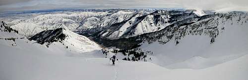
Overview
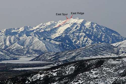

East Ridge route map

East Spur route map

East Spur upper ridge

Summit ridge
Cascade Mountain is a gem of the Wasatch Range. There are few visitors in the summer and even less in the winter. Climbing Cascade in the winter has always interested me. There are no routes to the summit that are free of avalanche danger and/or technical climbing. So for the last 5 years that I've been backcountry skiing, one of my goals was to gain the skill and experience necessary to ascend and ski this mountain safely. I finally did it this year after two prior attempts. For a winter ascent of Cascade Mountain, I would say the most efficient route is the East Ridge or the East Spur. Those routes will be detailed here.
STATS:
Vertical Gain: 5,233 feet.
Round Trip Distance: 10.5 miles.
CAUTION: Note that these ascent routes follow large avalanche paths and travel through avalanche prone cirques. Only travel these routes with experience and skill in avalanche terrain and the ability to make safe, informed decisions.
Click for the Full Trip Report on my photography website.
From the mouth of Provo Canyon, travel 5.9 miles to the Vivian Park Exit. Exit the highway to the right across the bridge and railroad tracks, and continue up the South Fork Road. Follow this paved road for another 3.5 miles to the National Forest Access sign. Turn right into a small parking lot with a park, pavilion, and benches. A small road will continue west for another 100-200 yards to a second parking lot. The trailhead is on the south (left) side of this second parking lot. This is the trailhead for Big Spring Hollow.
Continue past the camp for another 300 yards to a small meadow. You should see a trail sign (unless the snow is too deep) that marks the convergence of a few summer trails. This is the point where the left fork and right fork of Big Spring Hollow begin to split. You want to take the right fork. From this point forward, you will likely be breaking your own trail through the snow. Hike up the right fork 1.25 miles, until the forest opens and you reach the lower basin of Big Spring Hollow Cirque. The lower basin is where the East Ridge and East Spur routes split:
The East Ridge route is less exposed to avalanches, but has 4th class scrambling over cliff bands that bisect the ridge. I think the East Ridge is better for firm spring/early summer snow.
The East Spur is more exposed to avalanches, but travels 2nd/3rd class terrain that is more efficient if you are using skis and the snow is deep and unconsolidated.
From the lower basin, hike directly north to gain the east ridge. Continue up the east ridge and you'll find three separate cliff bands that bisect the ridge. Each cliff band is roughly 20-30 feet of 4th class terrain. You can bypass these cliffs on the south (left) slopes. This would be fun terrain for firm spring/early summer snow climbing. With deep mid-winter powder it would be difficult to negotiate. Above the cliff bands, hike the remaining 2nd class ridge to the summit. The East Ridge ends directly on the summit.
East Spur:
From the lower basin, hike northwest up the drainage. This will likely be filled with solid avalanche debris that will make the hiking fast. Continue into the upper basin of Big Spring Hollow. In the upper basin, you'll see the East Spur in the middle of the basin. The base of the spur is a small group of large pine trees. Ascend to those trees and you'll see the spur ridge to the summit. This is mostly 2nd class terrain, with possible 3rd class through one cliff band. The cliff can be easily bypassed on the south (left) slope. The East Spur ends on the summit ridge, just below the summit of Cascade. It's an easy walk from here to the summit.
CAUTION: It's worth noting again that these upper cirques are notorious for big avalanches. Even in "safe" conditions, there can be variable wind slabs on the broad upper ridge lines for both the East Ridge and the East Spur. Only travel these routes with experience and skill in avalanche terrain and the ability to make safe, informed decisions.
Avalanche Safety Gear (Beacon, Shovel, Probe, Avalung, etc.)
Crampons/Axe in firm spring/early summer snow
![Cascade Mountain]()
Getting There
Take I-15 to the 800 North Exit in Orem. Turn east onto 800 North, and continue toward Provo Canyon. As you enter Provo Canyon, 800 North will transition into an onramp onto US Highway 189 which travels up Provo Canyon.From the mouth of Provo Canyon, travel 5.9 miles to the Vivian Park Exit. Exit the highway to the right across the bridge and railroad tracks, and continue up the South Fork Road. Follow this paved road for another 3.5 miles to the National Forest Access sign. Turn right into a small parking lot with a park, pavilion, and benches. A small road will continue west for another 100-200 yards to a second parking lot. The trailhead is on the south (left) side of this second parking lot. This is the trailhead for Big Spring Hollow.
Approach
The East Ridge and East Spur routes share the same approach. From the Big Spring Hollow trailhead, hike roughly 2.5 miles to the School District Campground. This trail is actually a summer 4WD road to the campground, so expect a large path through the forest. These first 2.5 miles receive a lot of snowshoe traffic. You've reached the School District Campground when you see a basketball hoop on the right (north) side of the trail. You'll also see a small supply shed.Continue past the camp for another 300 yards to a small meadow. You should see a trail sign (unless the snow is too deep) that marks the convergence of a few summer trails. This is the point where the left fork and right fork of Big Spring Hollow begin to split. You want to take the right fork. From this point forward, you will likely be breaking your own trail through the snow. Hike up the right fork 1.25 miles, until the forest opens and you reach the lower basin of Big Spring Hollow Cirque. The lower basin is where the East Ridge and East Spur routes split:
The East Ridge route is less exposed to avalanches, but has 4th class scrambling over cliff bands that bisect the ridge. I think the East Ridge is better for firm spring/early summer snow.
The East Spur is more exposed to avalanches, but travels 2nd/3rd class terrain that is more efficient if you are using skis and the snow is deep and unconsolidated.
East Ridge & East Spur
East Ridge:From the lower basin, hike directly north to gain the east ridge. Continue up the east ridge and you'll find three separate cliff bands that bisect the ridge. Each cliff band is roughly 20-30 feet of 4th class terrain. You can bypass these cliffs on the south (left) slopes. This would be fun terrain for firm spring/early summer snow climbing. With deep mid-winter powder it would be difficult to negotiate. Above the cliff bands, hike the remaining 2nd class ridge to the summit. The East Ridge ends directly on the summit.
East Spur:
From the lower basin, hike northwest up the drainage. This will likely be filled with solid avalanche debris that will make the hiking fast. Continue into the upper basin of Big Spring Hollow. In the upper basin, you'll see the East Spur in the middle of the basin. The base of the spur is a small group of large pine trees. Ascend to those trees and you'll see the spur ridge to the summit. This is mostly 2nd class terrain, with possible 3rd class through one cliff band. The cliff can be easily bypassed on the south (left) slope. The East Spur ends on the summit ridge, just below the summit of Cascade. It's an easy walk from here to the summit.
CAUTION: It's worth noting again that these upper cirques are notorious for big avalanches. Even in "safe" conditions, there can be variable wind slabs on the broad upper ridge lines for both the East Ridge and the East Spur. Only travel these routes with experience and skill in avalanche terrain and the ability to make safe, informed decisions.
Essential Gear
Skis/SnowshoesAvalanche Safety Gear (Beacon, Shovel, Probe, Avalung, etc.)
Crampons/Axe in firm spring/early summer snow
External Links
Click to see my trip report.