
-
 5404 Hits
-
 79.04% Score
-
 10 Votes
|
|
Route |
|---|---|
|
|
40.30700°N / 111.588°W |
|
|
Mountaineering |
|
|
Spring, Winter |
|
|
A long day |
|
|
Steep hiking on snow, with moderate exposure in places |
|
|
Overview
Note: I didn't make it all the way up this route, so take my comments with a grain of salt.The northeast ridge route offers a fairly safe winter route for ascending Cascade. It stays on a ridgeline almost the entire time, mitigating avalanche risks.
There's no official, maintained trail on this route. Instead, you just follow the top of a ridge all the way to the summit. Scrub oak would probably make the route somewhere between miserable and impossible in the summer.
One-way distance: about 5 miles
Elevation gain: +5800 feet -400 feet = 5400 feet
Estimated ascent time: 8-12 hours
Estimated total time: 14-20 hours
 Route map
Getting There
The trailhead is at South Fork Park. To get there, drive up Provo Canyon and turn at Vivian Park. Continue past Vivian Park and drive about 1.7 miles to South Fork Park. There is parking right next to the road.Route Description
 Ridge traverse
Continue up the ridge. At about 8640 feet, you will come to a small cliff. The slopes below the cliff are smooth and steep and could be avalanche-prone, so be careful. One-at-a-time travel is recommended in this area. Pass below the cliff on the left and turn right to climb 200 feet to a corniced ridgeline.
Traverse directly south on the ridge for a little over 0.3 miles, then turn southwest and descend slightly to a small saddle. From here, you have a steep, straight, 800-foot climb to point 9660. There will be a large tree that you have to pass in a particularly steep section; pass it on the left to stay on firmer snow.
From point 9660, traverse on the northeast side of the ridge through deep snow to point 9917. (We turned around in the middle of this section after 6h20m of climbing, so everything from here on out is just speculation.)
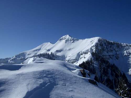 Middle and north summits. The crux of the route follows the ridge above the trees on the right.
The crux of the climb is a steep 700-foot climb from point 9917 to the main north-south Cascade ridgeline, visible in the photo above. It appears that the only tenable option is to continue directly up the ridge, probably on its north side through trees and possibly deep snow. There is a couloir on the left that may be an option in the spring if snow conditions are good. Traversing the cirque on the north to gain the ridge looks like a very poor option due to exposure, danger of rockfall, and avalanche risk.
Once on the main Cascade ridgeline, continue south for a little over half a mile, passing up, over, and down the north summit to reach the highest point at the middle summit.
If snow conditions are good, you may be able to ski or board down the east face, exiting through Bunnells Fork.