
|
|
Route |
|---|---|
|
|
40.27727°N / 111.59341°W |
|
|
Mountaineering |
|
|
Spring, Summer, Fall, Winter |
|
|
Most of a day |
|
|
Grade III |
|
|
Overview
Grr (or White Cascade) Couloir is the western most of several couliors on Cascade Mountain's south face. It is a moderately steep, but sustained route gaining ~2500 feet (~800m) in approximately six-tenths of a mile (average angle around 35 degrees). Looking up Grr Couloir.
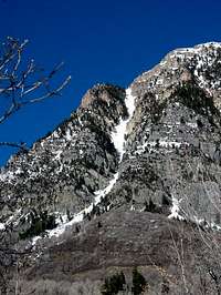
It is a striking line, but one not easily seen from Utah Valley or Squaw Peak road. Consequently, it is even less frequently climbed than the mountain's other couilors.
Approach
In the Spring or Early Summer (the route is not recommended in full summer when the snow is gone) this route is easily approached on Squaw Peak Road. Park on squaw peak road 1/4 mile north up the road from the obvious gully leading to the Crow's Foot routes. The drainage leading up to the base of the route is not very big or prominent. You cannot see the couloir from the road.Start bushwhacking here in a northeasterly direction.
Approaching the mountain during the winter means an extra hike up rock canyon, through the campground, up the road to the base of the route.
Route Description
From the Summer parking spot on Squaw Peak Roak, bushwhack northeast for about 10-15 minutes. At this point the lower part of the coulior is visible and the route is clear.Climb the coulior for ~2500 feet to a small saddle.
 Climbing Grr Couloir, November 2010.
 Climbing Grr Couloir, November 2010.
Traverse north away from the sharp ridge directly adjacent to the saddle, and climb up to the South Summit.
If there is any concern of debris loosening as the day goes on, descend via the South Summit Couloir or Upper Pole Couloir to the road, then walk back to the starting spot on Squaw Peak Road.