
-
 6979 Hits
-
 81.18% Score
-
 13 Votes
|
|
Route |
|---|---|
|
|
34.23696°N / 118.14657°W |
|
|
Hiking |
|
|
Spring, Summer, Fall, Winter |
|
|
Half a day |
|
|
Moderate |
|
|
Overview
Brown Mountain’s long summit rises between Millard Canyon and Bear Canyon in the front range of the San Gabriel Mountains. This route begins at Eaton Saddle along fire road and trail to Tom Sloan Saddle and then up the mountain’s east ridge. The route is about 8 miles roundtrip and is one where the summit (4,466’) is lower than the trailhead (5,110’). Of course that means that most of the elevation gain is on the return. Middle is east ridge sweeping back toward Sloan Saddle 4.11.08
Getting There
From the 210 Freeway, exit at Angeles Crest Hwy (SR 2) and go north. At 9.5 miles, you will come to the Clear Creek Information Station and junction with Angeles Forest Highway. Continue straight on SR 2 about 4.5 miles to the junction with the Mount Wilson Road at the Red Box Station. Turn right. Drive 2.3 miles to the trailhead (there is a white gate at the start of the fire road). There is parking here on both sides of the road.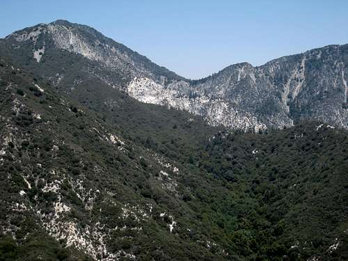 Eaton Saddle with San Gabriel Peak on left seen from Muir Peak
Route Description
From the Eaton Saddle trailhead parking area, pass the white gate and hike west on the Mt. Lowe Fire Road. You will immediately see, to the right, the massive south face of San Gabriel Peak (6,161 ft.). On your left, you’ll get a great view of deep, rugged Eaton Canyon as it snakes its way up from the San Gabriel valley floor. Looking down Eaton Canyon from near trailhead
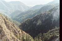 Another view of Eaton Canyon
In a little over a quarter of a mile, you will pass through the Mueller Tunnel, which tunnel was blasted right through San Gabriel Peak’s south face. When you envision where the road would need to go if the tunnel wasn’t there, you’ll see the reason for the tunnel.
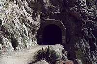 Mueller Tunnel through south face of San Gabriel Pk
 Mt. Markham (5,742') seen from near trailhead
In about ½ mile, you’ll come to Markham Saddle between Mt. Markham, on your left, and San Gabriel Peak, on your right. Continue on the fire road another 1.3 miles. Here, you come to a point where the fire road starts descending to your left. Continue straight ahead instead of following the fire road down. You will immediately encounter a flat area at the end of which the trail to Sloan Saddle begins. It is a 1.2 mile descent to Sloan Saddle from here.
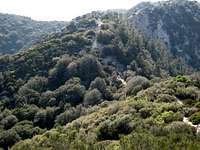 Looking down to Sloan Saddle and beginning of east ridge route
Sloan Saddle is the divide between Millard Canyon and Bear Creek. It is a five-trail junction: one trail goes to Dawn Mine; one down into Bear Canyon; two, including the one you came in on, back to the Lowe Fire Road; and the use trail to Brown Mountain. Pick up the use trail that begins a very steep ascent going west. The use trail is etched below the very top of the ridge so keep to the right of the ridge top as you ascend.
 Indian Paintbrush on slope of east ridge, 4.11.08
The ascent along the ridge from the saddle to the summit is approximately one mile with about 900 feet of gain including three major descents and ascents. The summit is currently marked by a stone pile containing a register can.
Red Tape
You will need an Adventure Pass ($5 per day or $30 for a yearly pass) to park your vehicle at Eaton Saddle. These passes are sold at many forest service stations and can also be purchased at most sporting good stores.No permits are required for hiking.
Essential Gear
None. Running shoes are adequate for this route. There are no water sources along the way so bring what you need.Other Information
USGS Topo Maps: Pasadena 7.5.Historical Note: This mountain is named after the mid-19th American abolitionist, John Brown, famous for the Harper Ferry Raid. His two sons came out to California and settled near the head of El Prieto Canyon in the 1880’s. They spent a lot of time exploring the San Gabriel front range. To honor their father, the sons named this mountain after him.
External Links
Angeles National Forest InformationAdventure Pass Information
California Dept. of Transportation
jsmog - Jun 22, 2011 6:29 pm - Hasn't voted
Trail from Tom Sloane Saddle to Switzer's FallsGreetings, We just "completed" a hike in the same area and have a warning. The landslide is still easily visible at the end of Mueller Tunnel (and pretty amazing...destroyed the fire road and smashed the west portal of the tunnel.) We were trying to do an "ash-walk" since the fire. I THOUGHT the trail was open, but the signs are still up, so we were asking for a nice big citation. We intended to hike down from Eaton Saddle, across Markham Saddle and then follow the trail down into Bear Valley all the way to Switzer's, but after Tom Sloane Saddle (where the trail turns down into Bear Valley) it was completely choked with lupine. Lacking a machete, we edged about 100 feet into the lupine, but soon found ourselves covered with nectar and surrounded by bees. Not wanting to suffer such a romantic fate, we turned back and ended up hiking up to Switzer's Falls from that picnic area instead. All of the trails and fire roads, even the very popular Switzer's, look to be in bad shape. I think the Angeles, like so many places, is going to be for the hardcore only.
Augie Medina - Jun 23, 2011 3:13 pm - Hasn't voted
Re: Trail from Tom Sloane Saddle to Switzer's Fallsthanks for that detailed update; very helpful. When I get a chance I'll incorporate your information on the page.