
-
 26245 Hits
-
 83.69% Score
-
 17 Votes
|
|
Mountain/Rock |
|---|---|
|
|
34.23696°N / 118.14657°W |
|
|
Los Angeles |
|
|
Hiking |
|
|
Spring, Summer, Fall, Winter |
|
|
4466 ft / 1361 m |
|
|
Overview - Historical Name and Fun Ridge Routes
NOTE: At long last, access to this peak is once more available after having been closed off since the greatly destructive "Station" fire that ravaged the San Gabriel Mountains in August and September of 2009.Brown Mountain is as nicely positioned for scenic views as a mountain surrounded by higher peaks can be. Its long summit rises between Millard Canyon and Bear Canyon in the front range of the San Gabriel Mountains.
This mountain can be approached from various trailheads. In particular, the routes following the streams up Millard Canyon and down Bear Canyon to Brown Mountain’s east ridge are beautiful narrow canyon passages and can be adventuresome if the streams are running high. Another factor that makes climbing this mountain fun is that the ascent routes from both the east and west ends of the mountain are along firebreaks as opposed to regular trail. The west ridge presents a little bush-whacking while the east ridge has you negotiating three false summits before arriving at the real one.
This mountain is named after the mid-19th American abolitionist, John Brown. It seems that his two sons lived near the head of El Prieto Canyon in the 1880’s and spent a lot of time exploring the front range. To honor dear old dad, the sons named this mountain after him.
The ascent to the summit is by either the mountain’s east ridge or northwest ridge along a firebreak that spans the length of these ridges. The approach to the northwest ridge route is the least interesting because it consists of 6 miles of fire road from the Millard Canyon Campground trailhead. However, this is the steepest route because you’ve got 1,600 feet of gain on the ridge in about 2 miles to reach the summit from the fire road.
On the other hand, the approach to the east ridge route from the Switzer Picnic Grounds trailhead takes you stream hopping down the stunningly beautiful Bear Canyon to the base of the ridge at Tom Sloan Saddle. Including the summit, this route is about 13 miles round-trip.
Another stream route to the east ridge starts from the Millard Canyon Campground trailhead. This route climbs immediately above Millard Falls, upstream through Millard Canyon to Dawn Mine, and then to Tom Sloan Saddle (including summit, this is 9.5 –10 miles roundtrip with 2,900 ft. of gain). A variation of the latter route starts at the Sunset Ridge trailhead and reaches Sloan Saddle also via Millard Canyon and Dawn Mine. This variation is hike No. 21 in John Robinson’s Trails of the Angeles.
Once at Sloan Saddle (this is the divide between Millard Canyon and Bear Creek), you pick up the firebreak/use trail going west and ascend the ridge for a little over one mile, with about 900 feet of gain, to the summit. Below is a view along the east ridge:
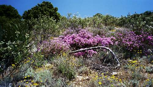 View Along Brown Mountain's East Ridge
A final approach to the east ridge is from the Eaton Saddle trailhead. This approach is on fire road and trail to Tom Sloan Saddle and then up the ridge. This route is about 8 miles roundtrip.
For a peak under 5,000 feet, you get your money’s worth of panorama at the summit. Looking north, beyond Bear Creek, your eye catches the distinctive shape of Strawberry Peak and Josephine Peak to its left. To the east stand San Gabriel Peak, Mt. Markham and Mt. Lowe. To the west is the magnificent chasm that is the Arroyo Seco and across Angeles Crest Highway, you can make out the antennas of Mt. Lukens in the distance. To the south is Millard Canyon and beyond that, a usually hazy view down into the San Gabriel Valley metropolis.
Getting There
Here are directions to the trailheads mentioned above giving access to Brown Mountain.Eaton Saddle--From the 210 Freeway, exit at Angeles Crest Hwy (SR 2) and go north. At 9.5 miles, you will come to the Clear Creek Ranger Station and the junction with Angeles Forest Highway. Continue straight on SR 2 about 4.5 miles to the junction with the Mount Wilson Road at the Red Box Ranger Station. Turn right. Drive 2.3 miles to the trailhead (there is parking here on both sides of the road).
Sunset Ridge and Millard Canyon Campground --From the 210 Freeway exit at Fair Oaks Ave. and take Fair Oaks north toward the mountains. At Loma Alta Drive, turn left and proceed about ½ mile to Chaney Trail Drive. Turn right onto Chaney Trail Drive and ascend to Sunset ridge. For the Sunset Ridge trailhead, take an immediate right to the parking area in front of the white gate (the parking is very limited here but you can also go back down Chaney Trail Drive and park along the road).
For the Millard Canyon Campground Trailhead, when you get to Sunset ridge, make a left and take the road down to the bottom of Millard Canyon. Here, there is a large paved parking lot next to the creek.
Switzer’s Picnic Area—From the 210 Freeway, exit at Angeles Crest Hwy (SR 2) and go north. At 9.5 miles, you will come to the Clear Creek Ranger Station and the junction with Angeles Forest Highway. Continue straight for about ½ mile and turn right at the sign for Switzer Picnic Area. Drive ¼ mile down to the parking area.
Red Tape
You will need an Adventure Pass ($5 per day or $30 for a yearly pass) to park your vehicle anywhere within the Angeles National Forest, including all the trailheads mentioned here. These passes are not sold at most trailheads. However, they are currently sold at the Red Box Ranger Station (which is on the way to the Eaton Saddle trailhead). Otherwise, they can be purchased at sporting good stores.No permits are required for hiking.
Bob Burd - Jun 26, 2011 5:35 pm - Hasn't voted
updated info"NOTE: At the present time, and until further notice, the Angeles National Forest, including access to this peak, is closed to access due to the greatly destructive "Station" fire that ravaged the San Gabriel Mountains in August and September of this year." This restriction has been lifted.
Augie Medina - Jun 26, 2011 8:05 pm - Hasn't voted
Re: updated infoThanks Bob