
-
 9994 Hits
-
 73.06% Score
-
 3 Votes
|
|
Route |
|---|---|
|
|
39.42310°N / 106.1228°W |
|
|
Hiking, Mountaineering, Scrambling |
|
|
Spring, Summer, Fall |
|
|
Most of a day |
|
|
Class 4 |
|
|
II |
|
|
Overview
This is yet another alternative on a surprisingly versatile peak. The east ridge is over a mile long and seems to throw in another surprise just when you think it will end. The rock itself is very solid although holds should always be tested. The ridge crest can be followed almost the entire route including the improbable-looking class 4 crux, however a few route-finding problems will be encountered. For those adverse to exposure, the south side of the ridge is less steep and offers many escape opportunities, either around cruxes or back into McCullough Gulch if necessary. Best of all, no trail exists from the road to the ridge, so the entire outing is an adventure. This ridge is a great warmup for other long, difficult scrambles. For the big spenders, you can find more pictures of this route in Colorado Scrambles by Dave Cooper.Getting There
As stated above, there is no trail to follow so you have to get yourself to the proper starting point. The "trailhead" is in McCullough Gulch. Follow CO-9 to CR-850 to CR-851, the usual sequence to the Quandary trailhead. Drive 1.6 miles on CR-851 to where a branch of the road suddenly dives downhill. Follow this rougher, steeper branch down to the creek then back uphill to the Wheeler trail. Follow a bend in the road uphill and park at some campsites near an old mining shack. A steep hillside will hang above you - get ready to hike straight up it!By the way, I think passenger cars can make it to this trailhead but the return back to CO-851 may be challenging.
Route Description
 The charming basin
Hike directly up the hillside above the parking area. After several hundred feet of climbing you will enter a small basin that may or may not have a few elk running around it, no promises. The apparent high point above the basin is the start of the east ridge. Hike directly to it or contour around the eastern rim of the basin to get to it. Once above the basin, you will see the east ridge, broad and flat at first but getting progressively narrower.
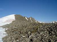 The start of the ridge
Climb it. The scrambling begins as Class 2 boulder-hopping but gets progressively more difficult. The crux is about half way along the ridge. When you see what you are convinced is the last tower, you'll be about 2/3 done. The ridge finally relents just within sight of Pacific Tarn as it mellows back into Class 2 scrambling. Cross below the lake's outlet and boulder-hop the remaining 500 feet to the petite summit.
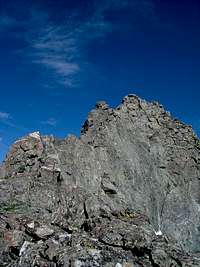 The crux tower
Descend by the standard McCullough Gulch route. Follow CO-851 back to the spur you parked on. If you look carefully, there's a bit of a shortcut on the return. Along 851, look for the Quandary Tunnel North Portal to your right. To your left is a steep embankment with a faint path running diagonally. Scramble 10 feet down to the path and follow what becomes the obvious remains of a 4WD road. After 1/4 mile, it will dump out near the low point of the spur road. Turn left and walk back to your car.