
-
 6702 Hits
-
 72.93% Score
-
 3 Votes
|
|
Route |
|---|---|
|
|
48.00400°N / 121.4909°W |
|
|
Scrambling |
|
|
Spring, Summer, Fall, Winter |
|
|
Most of a day |
|
|
steep scrambling on rock or snow |
|
|
Class 3 |
|
|
Overview

This route is difficult, requiring lots of steep scrambling & bushwhacking. Careful routefinding is the key, especially on the descent as it is very easy to get cliffed out. Summer and early fall ascents will include lots of talus and heavy brush. Winter is easier, although extreme caution must be taken at the top because of steep exposed snow.
The route begins on the Sunrise Mine/Headlee Pass trail, but splits off just before crossing the Stillaguamish River, where it continues up the Stilly valley towards Del Campo Peak. The route turns and ascends the east side of the mountain to a saddle SE of the summit. From the saddle, one must cross beneath the summit cliffs to the summit ridge (the ridge extending south from the summit). Then a short scramble leads to the top.
Getting There
From the Sunrise Mine/Headlee Pass trailhead, follow the trail through the woods across several stream crossings. At about half a mile, the trail will come to the South Fork Stillaguamish River. Do not cross the river, instead head uphill, and look for a small path leading up the valley on the east side of the river. It may be difficult to find due to heavy brush.In the winter when this road is snow covered, you may not be able to get past the gate at Deer Creek. Check the Forest Service website on information for the Mountain Loop Hwy before you go. If the gate is open, you will most likely not be able to drive it if it is covered in deep snow. I had to park on the highway and snowshoe 2 miles to the trailhead.
Route Description

Follow the small bootpath as it ascends the South Fork Stillaguamish valley (on the east side of the river). In the summer there will be heavy brush. In the fall it will likely be very muddy & wet.
After about half a mile, the trail will meet with the river. From here, you will follow the river until a possible route presents itself up the hillside to the right. The green Beckey says after 3/4 of a mile to ascend a boulderfield on the right (Cascade Alpine Guide). The first time I was up there in October, I never saw any such boulderfield, and we followed the river for quite a bit before ascending a steep gully instead (this later proved to be a mistake). Basically, your goal is to ascend this hillside to a broad basin below the southeast ridge. There are several possible routes to reach this basin, but however you go it will be steep scrambling. When I was finally successful in December 2005, I went upriver until I reached a large house-sized boulder. From here I ascended a steep snow-filled gully to the right. This was not very easy, but it was much easier than the gully further upriver that I had taken before. The hillside has lots of cliffs, steep slabs, and steep gullies which impede travel and must be navigated carefully (especially on the descent).
 Lower east route (courtesy of Dayhike Mike)
The broad upper basin lies below the southeast ridge and is blocked on the SE side by a HUGE slab. From here there will be five different peaks of similar height visible along the ridge to confuse matters. The large rounded dome is the true summit; you want to head for the saddle immediately to the left of it.

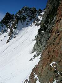
From the saddle, the summit will rise steeply up and to the right. You want to aim for the ridge on the far side, by passing under the summit cliffs and then turning right up a steep gully to the ridge. This becomes quite steep. When snow covered, you will want an ice axe although the runout seems pretty safe. Once you reach the ridge, it is a short & steep scramble to the top. It was snow-covered when I was up there which made a very exposed ascent (a fall would have been fatal).
When descending the route, you will probably want to follow the way you came up. I made the mistake of trying an easier route on the way down, which only led me to being cliffed-out and then I was in trouble. Make sure you either wand your route or look back occasionally on the way up!