
-
 5121 Hits
-
 71.06% Score
-
 1 Votes
|
|
Route |
|---|---|
|
|
46.61010°N / 11.76790°E |
|
|
Scramble / Ferrata |
|
|
Less than two hours |
|
|
KSC-2 |
|
|
Approach
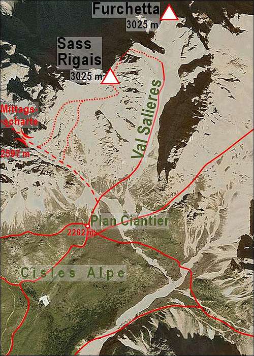
Take the Brenner motorway A22 to the exit of Waidbruck (Ponte Gardena). Turn onto S242 east either to St. Ulrich (Ortisei) or St. Christina. From St. Ulrich you can take the cablecar to Seceda (2518m), the westernmost summit of the Geisslergroup. From St. Christina you can take the lift to Col Raiser (2102) on Cisles Alpe. From both cable cars you need to hike to Col de Coi (2301m), where the trail into Wasserrinnental (Val Salieres) starts.
Route Description
Altitude gain: 1000m from Col Raiser
Duration 1h 15min
Trailhead: Forca Salières (2696m)
This is the old normal Ascent route and quite popular. It is usually combined with one of the other routes to form a neat circle.

From the Col take the right (eastern) trail (signs: Ferrata, Klettersteig) and head for the deep gorge between Sass Rigais and Furchetta, which is called Wasserrinnental (Val Salières). The trail turns right to the base of Furchetta and the winds upwards to Forca Salières (2696m) which separates the two giants.
Now turn left through a couloir towards a large 10m step, which can be surmounted with the help of cables and spikes. This is the most challenging part of the ascent. The remainder of the trail leads over ledges and boulders (where neccessary always secured by cables) to the summit.
 |
 |
 |
Essential Gear
Hiking gear and a ferrata set (harness, two short ropes with carabines) are sufficient. A helmet might be useful.