
|
|
Mountain/Rock |
|---|---|
|
|
40.98886°N / 112.24273°W |
|
|
Davis |
|
|
Hiking |
|
|
Spring, Summer, Fall, Winter |
|
|
5126 ft / 1562 m |
|
|
Overview
 Elephant Head trail
Long hike, short climb.
Elephant Head, located on the northern part of Antelope Island is a 5,126 foot peak south of Buffalo Point across White Rock Bay. It is a non-technical 9.5 mile round trip hike across a grassy plain and up to Utah’s 4112th highest summit. Since it’s on the West part of the Island it is a little harder to spot from the highway than most of Antelope Island peaks but the hike is straight forward and it’s difficult to get lost. Most of the trail is well-marked YDS 1 and finishes with a quarter-mile scramble up a ridgeline to the summit.
Elephant Head’s summit is a rocky bluff overlooking the Great Salt Lake. The shape of the hill vaguely resembles an elephant head with the trunk being the long ridgeline…really more imagination than anything. From the top, you are rewarded with a spectacular, sweeping view of the lake and mountains ranges to the north and west. There are plenty of good rocks to sit on and zen to the sights. Scramblers can follow the established trail to the end and go up the YDS 4 rocks on the north-side of the bluff, while non-scramblers can simply follow the south-side ridgeline to the top. The terrain for the entire hike is dry, plains-like grasslands.
When to Go
 Elephant Head Summit
The trail to Elephant Head on Antelope Island is open year round. With only a single tree on the entire route, the most un-pleasant time is during high summer.
The best times to tour the Island and attempt any of the island peaks are in the late fall, early spring and winter when the crowds are sparse and the flies in hibernation. In addition, there seems to be more animal activity during the day increasing the likelihood of getting that great camera shot. For late fall and early spring visits, you will most likely encounter some light snow on the ground but not anything you’d need special shoes for. The area around the island is great for winter snowshoeing and possibly cross country skiing.
HIKE INFO
From Lists of John
Elephant Head
Elevation : 5,126'
UT Peaks Rank : 4112
Quad : Antelope Island
Coords : 40.988864, -112.242733
Rise : 356'
Saddle : 4,770'
Trailhead Location: 41.024269, -112.240191
Trailhead Elevation: 4240
Round Trip Distance: ~9.5 miles
Round Trip Time: ~ 4 hours
Trailhead to Summit Elevation Gain: ~886 feet
Difficulty: YDS Class 1 (for most of hike) with easy scrambling to the summit
Hiking Route
 4950 and grassy plain
The most common and direct route to Elephant Head begins at the south end of the White Rock Bay Campground. There is a “Day Use” parking area near the chain link fence. After going through the gate, head generally south-west on the main trail. The trail roughly follows the shoreline. After about a mile, there is a short dogleg and then the trail starts across the plain. From here you can see Elephant Head to the west. The trail across the plain goes straight for ~2 miles until you reach the only tree on the entire hike (next to a horse hitching post). From the tree the trail begins its rise. Continue on the trail until you see Elephant Head to the right. The trail splits and the right fork heads west toward Elephant Head. The Antelope Island map clearly shows a trail the summit but it is either hard to see or non-existent. The easiest way to summit is to leave the trail at the base of the final hill and follow the ridge to the summit.
The most common alternate route is to take a hard left immediately out of the gate and follow that trail east and south over Hill 4950 and across the plain. The trails will join up about 50 feet north of the tree.
The rangers will give you an island map when you pay to come on the island.
Hazards
 Yup...the only tree on the WHOLE route
HAZARDS:
Your primary hazards on the route are the heat, micro-fauna and mega-fauna.
Antelope Island is on the edge of the western desert. The terrain is absolutely shade-less the entire route and, during the summer, it gets uncomfortably hot. Over the course of the hike, there is exactly one (1) tree for protection and it’s located about 2/3-way to Elephant Head. The good news is it catches a nice breeze; the bad news is it is the only shade on the route. You need to bring water, sunscreen and wear long sleeves for sun protection.
There is an abundance of micro-fauna (known collectively as “bugs”) infesting Antelope Island from May to October. The bugs are especially obnoxious during the summer when they swarm, bite and get ingested into random bodily orifices. The flies and gnats are incredibly thick on the Elephant Head Summit but they also lurk out there on the trail, breeding in the buffalo flops and waiting to attack the entire way. Even when they aren’t biting, the tiny gnats stick to sweaty skin and you can come away with a thousand bug carcasses stuck to your face. Either load up on DEET or visit the island after October or before May.
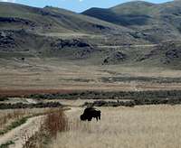
 MOO! Photo by Phenom
Finally, there is a herd of buffalo on the island. They are big and they can hurt you. You may encounter them at any point in the hike, all the way to the summit. They seem to congregate on the plains portion and have a favorite spot within feet of the trail. The island rangers advise either going around or waiting them out. Buffalo may look slow, but they can run like the wind and will gore people who are silly enough to get to close. Don’t.
External Links
 View from the top photo by Mtgazelle
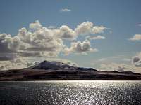 Antelope Island from causeway
WEBSITES and INFO
www.WillhiteWeb.com
www.utah.com/stateparks/antelope_island.htm
www.utah.com/daviscounty
www.hikinginutah.com
http://www.listsofjohn.com/
http://www.utahhikes.net/elephant/display50.html
http://www.utahmountainbiking.com/trails/antelope.htm
CONTACTS
Park Headquarters : 801-652-2043
Visitor Center: 801-725-9263
Park Entrance Gate: 801-773-2941
Antelope Island State Park
4528 West 1700 South
Syracuse, Utah 84075-6868
(801) 773-2941
Getting There
 Antelope Island Map
 Buffalo pen at the trailhead
The trailhead is located at 41.024269, -112.240191 at the south end of the White Rock Bay Campground. In general, take exit 332 off I-15, drive west on Antelope Drive through Syracuse toward the Great Salt Lake. Pay the $9 entry fee at the ranger shack to get onto the causeway and into the park. Drive the 7.5 mile causeway across the lake. Once across, you’ll see an Air Force/ Special Forces Memorial and a small Marina. There are signs directing you to White Rock Bay Campground and/or “Backcountry Trails”. Simply follow the signs to the West Part of the Island, park at the south end of the White Rock Bay Campground (where it says Day Use Parking) and hit the trail.
Facilities on the island include rest rooms, hot shower rooms, picnic/group shelters, boat launches, marina, cafés, information and a large Visitor Center. Facilities at Garr Fielding Ranch include rest rooms, but there isn’t a water source. Bring your own!
The Davis County Causeway from Syracuse to the Island is an interesting piece of construction that has been built, rebuilt and rebuilt again. The 7.5 mile causeway linking the island to the mainland is an earthen dike that was originally built in 1969 and was heavily damaged by the lake’s waves. The state made numerous improvements raising the causeway. Heavy snows and rains in the early 80s raised the lake’s level above the causeways and the road was completely under water. After the state’s drought lowered the lake’s level, the causeway was rebuilt in 1992. A good portion of the “causeway fee” goes toward a fund to rebuild it again if it is destroyed by future floods.
Red Tape and Camping
RED TAPEAntelope Island has a long list of “do’s” and “don’t” which vary from area to area on the Island. For the hike to Elephant Head, the rules are to stay on the trail, don’t light fires, no backcountry camping, and please avoid getting gored by the bison.
See the State’s website for detailed information and fees. You are on state land everywhere on the island. Check out the regulations before you visit.
In retrospect, lack of a trail to the summit could be problematic red-tape wise. The map clearly shows a trail to the top, but the actual trail goes around the north side and dead ends. This could mean one (or more) of three things:
A: I stink at trail finding
B: I stink at map reading
C: Few people actually climb to the summit
On a personal level, either “A” or “B” expose damning character flaws, while, if only “B” is true, there exists a potential for stringent counseling from a park ranger. I’m not sure I want to know….
CAMPING
There are 2 campsites for reservation located on the north part of the island.
Bridger Bay Campground
is the larger of the two with 26 primitive sites available. The sites include picnic tables, fire pits, and toilets are available. There isn’t, however water or electricity available. No horses are allowed
White Rock Bay Campground is smaller with 12 primitive sites. It is similar with picnic tables, fire pits, and toilets are available. Once again, there isn’t water or electricity available. Horses ARE allowed at this site.
Reservations may be made by calling Utah State Parks and Recreation, 322-3770 in the Salt Lake City calling area or toll-free 1-800-322-3770, from 8 a.m. to 5 p.m., Monday through Friday.
Should you decide to spend a couple of days, Antelope Island is great for running, biking, horseback riding, saltwater swimming, snowshoeing and boating. There are several places to grab a snack (in season) as well as picnic on the island.
Fauna
 Yes...the buffalo are that close!
Antelope Island’s main claim to fame is its herd of 700 free roaming American Bison. These magnificent creatures get to almost every point of the island and are invariably seen standing in herds. They are easily spotted and photographed. The herd is one of the oldest surviving herds in the US as it was spared from the extinction-level bison hunts that wiped out the huge plains herds in the 1880s. Two Utah men brought the animals to island in 1893 and essentially saved the species. As a result the herd’s vitality, the Antelope Island animals are used today to increase the genetic diversity of other free-roaming bison herds across the United States. These beautiful creatures are a vital national ecological resource.
In addition to the island’s signature bison, chances are pretty good you might also spot pronghorn antelope, bighorn sheep, coyotes, bobcats and/or mule deer. Since they aren’t hunted, these animals don’t hide as much as usual. The island itself was named after the pronghorn antelope that early explorers converted to rations. The original herd died out in the 1930s but a new herd of 24 was reintroduced in 1993.
While summiting the islands peaks, you’ll usually see several species of raptors soaring around the mountainsides. There is also a wide variety of local on the island including Grouse, Chuckars, and California Sea Gulls. During migration season you’ll spot everything from geese and ducks to willets and stilts along the shoreline and in the salt marshes.