
|
|
Mountain/Rock |
|---|---|
|
|
38.52030°N / 113.2876°W |
|
|
9660 ft / 2944 m |
|
|
Overview
Frisco Peak is the highest peak in the San Francisco Mountains. It is an interesting summit for several reasons including the face that is surrounded by two ghost towns and the mountain is made of purple quartzite.This rather isolated mountain rises high above the Utah desert just west of Milford. Although Frisco Peak is a dominating landmark in the area, it doesn’t seem to attract much attention. Unfortunately for climbers, there is a road to the summit as well as a large radio tower complex, but luckily for climbers, several good hiking and climbing routes do exist up the peak.
In addition to the road and radio towers, a hangliding platform has also been built on the summit because it is recognized as a good place to hanglide, though not many people visit the summit.
The historic mining town of Frisco was located at the southern base of Frisco Peak. It was founded in 1875 after a silver ore strike. The railroad reached here in 1880 and Frisco reached a peak population of 6,000. This declined after a mine cave in that happened in 1885 (luckily no one died in the collapse), but it was several years before the mine was abandoned and the town died away in 1920. At its hay day, Frisco was considered the wildest town in the Great Basin with 23 saloons and many gunfights and killings. All that remains now are the stories, some crumbling buildings, a cemetery, other artifacts, and the charcoal kilns which were used to make fuel for the smelter.
Recently, more mining claims were staked, so make sure to obey and private land signs.
Newhouse is the ghost town on the southwest slope of the mountain. It was founded in 1880, about the same time as Frisco and had a smelter built in 1892, but Newhouse wasn’t profitable until 1900 when Samuel Newhouse bought the mine. The town reached its peak at around 1905, but in contrast to Frisco, public drunkenness was forbidden and there was only one saloon outside town. The town began to die in 1910 before finally petering out in 1921.
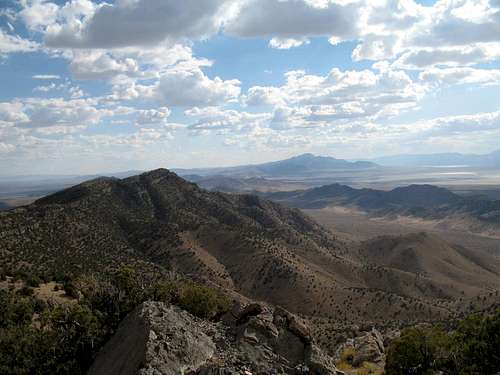
 Looking north from Frisco Peak.
Getting There
Charcoal Kilns and Morehouse Spring TrailheadFrom the town of Milford, drive west along State Highway 21. Between Mile Markers 65 and 64, turn north onto a gravel road. After a short distance, turn left onto the gravel road that follows Carbonate Gulch. This is a good road to the Carbonate Mine, but the road becomes rougher after the mine. If you have a car, park at the Charcoal Kilns. If you have a 4wd vehicle, you can continue up the road to near Morehouse Spring.
 Part of the access road to Frisco Peak.
Newhouse and Indian Queen Marble Mine Trailhead
From the town of Milford, drive west along State Highway 21. Between Mile Markers 58 and 57, turn north onto a gravel road. Continue north on the gravel road to the ghost town of Newhouse. Continue north along the gravel road that follows the old railroad grade. Stay on the main road which heads northeast to the Indian Queen Marble Mine (which is not the Indian Queen Mine marked on the topo map). Park just short of the gate. If you have a 4wd you can go down the hill to the west and up a steep track (not on the topo map) that leads to several old mines.
Routes Overview
Charcoal Kilns and Morehouse Spring RouteThis route climbs the mountain via the east side and from near Morehouse Spring. Because the route follows a 4wd track and old power cable, it is easy to find.
It is a steep route, gaining 1900 feet from the end of the 4wd track to the summit in 1.1 miles. If you begin the climb at the Charcoal Kilns, the route is 6.6 miles round trip with about 3000 feet elevation gain.
See the route page for details.
Newhouse and Indian Queen Marble Mine Route
This is a more difficult route than the above, but is more scenic and interesting. This route climbs the West Ridge of Frisco Peak from near the Indian Queen Marble Mine. It takes some routefinding to find the beginning of the route, but once on it, it’s easy to find. This route is also steep. Depending on where you park, this route is just over 2 miles long and has around 3000 feet elevation gain.
See the route page for details.
Other Routes
There are other routes on the mountain as well. The 4wd road to the summit makes an obvious route, but will not be discussed on this page.
Climbing the long south ridge from the highway and from near Frisco might make a long and interesting route as well.
 West side of Frisco Peak as seen from the Wah Wah Mountains.
Red Tape
There is no red tape, so make sure to practice LNT principles.Camping
There are many campsites in the area, but there is some private land around the ghost towns. The area around the Charcoal Kilns is a good place to camp.When to Climb
Frisco Peak gets much less precipitation and snow than the mountains of Northern Utah. Because of this, the snow-free hiking and climbing season is much longer than it is farther north.In a normal year, you can expect most of the snow to be gone from the ridge routes as early as early May. Heavy snows usually don't come until November, so early May through mid June and September through early November would be considered the normal climbing season. Summer is OK too, but a little warm, so take plenty of water if climbing the peak then.
Winter and early spring climbing is also possible. Unless you are there after a recent snowstorm, you can usually drive to the Charcoal Kilns on the southeast side of the mountain and Newhouse Ghost town on the southwest side of the mountain.
Gaiters should be taken, but because of light snowfall, snowshoes may or may not be needed, especially if you stick to the ridge routes.
 Looking south to Frisco Peak from the Cricket Mountains in September.
Mountain Conditions
CLICK HERE FOR FRISCO PEAK WEATHER FORECASTWeather and climate data for Wah Wah Ranch at 4960 feet elevation and near the base of Frisco Peak is below. *National Weather Service Data 1955-2008. Expect wetter and cooler conditions at higher elevations. The area around Frisco Peak will average around 15 degrees colder in the daytime than Wah Wah Ranch; nighttime temperatures won't have quite as big of a difference.
| MONTH | AVE HIGH | AVE LOW | REC HIGH | REC LOW | AVE PRECIP (in) |
| JAN | 43 | 14 | 74 | -27 | 0.32 |
| FEB | 50 | 21 | 76 | -29 | 0.39 |
| MAR | 58 | 26 | 88 | -3 | 0.58 |
| APR | 66 | 32 | 89 | 5 | 0.65 |
| MAY | 76 | 41 | 101 | 18 | 0.66 |
| JUN | 87 | 50 | 106 | 25 | 0.42 |
| JUL | 95 | 58 | 108 | 30 | 0.59 |
| AUG | 92 | 56 | 104 | 31 | 0.97 |
| SEP | 83 | 46 | 100 | 20 | 0.73 |
| OCT | 71 | 34 | 92 | -5 | 0.72 |
| NOV | 55 | 23 | 82 | -11 | 0.49 |
| DEC | 44 | 15 | 71 | -30 | 0.27 |