
|
|
Route |
|---|---|
|
|
46.10490°N / 7.87170°E |
|
|
Mountaineering |
|
|
Summer |
|
|
A long day |
|
|
ZS, IV- |
|
|
Overview
The ENE-ridge of the Lenzspitze is the normal route from the Mischabelhütte. Although it is the normal route, it should not be underestimated as the rock difficulty reaches up to UIAA IV-. Besides that, the route can include some tricky passages if the rock is covered with snow.Getting There
The starting point for this route is the Mischabelhütte. From here a path leads up the ridge behind the hut to the Hohbalmglacier. The glacier is crossed in southwestern direction to the beginning of the rocky ridge (1 hour).Route Description
The route starts with easy rock climbing along the ENE-ridge. This leads to a first steeper part. Here the route traverses a few meters to the left into a short couloir which leads to a plateau at the beginning of the grand gendarme. This gendarme (4091m) is climbed (IV-) directly. From the gendarme a rappel of 4m one reaches a plateau which is also called "Frühstücksplatz" (1,5 hours). From here the best way to continue is directly and subsequently slightly right on the ridge. Finally the last part of the ridge is climbed directly (III), followed by a narrow snowridge which leads up to the summit (1,5 hours).An overview of the ascent (red line) and descent (blue and green line) is shown on the photo [click for enlargement]
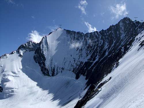 Overview of the ENE-ridge of the lenzspitze and its descent
Descent
The descent consists first of all of a traverse to the Nadelhorn (Blue line on the photo)(ZS, III+). This is a exposed, scenery rock ridge which is described by Waeber (Gebietsführer Walliser Alpen, 2003) as part of the Nadelgrat but is not considered a part of the Nadelgrat by Biner (SAC führer).The ridge consist mainly from the lowest point (Nadeljoch) to the Nadelhorn out of a several towers (4 larger towers and several smaller ones) which are directly climbed. Some have a rappelanchor as downclimbing over the slabs can be tricky especially in case of snow-covered rock.
The estimated time for the ridge is 2-2,5 hours, but it can easily take longer under suboptimal conditions. Keep this in mind!
After reaching the Nadelhorn, this is descented via the normal (NE-ridge) (Green line on the photo) in approximately 1,5-2 hours back to the Mischabelhütte.
Instead of descenting to the Mischabelhütte one can also descent via the S-ridge (Normal route from the Domhütte). This route is not recommended as it can be tricky due to loose rock.
Essential Gear
Rope, crampons, 1 iceaxe, biners and quickdraws, rack of nuts and sufficient wires(optionally some friends but these are not strictly necessary)
Literature
Hochtouren im Wallis, Hermann Biner, 2002 (SAC)Alpinführer Walliser Alpen 4/5 - Vom Theodulpass zum Simplon, Banzhaf, Biner, Burgener, 2009 (SAC)
Gebietsführer Walliser Alpen, Michael Waeber, 2003 (Rother)