A great adventure
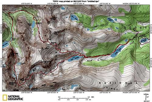
![Fair Glacier Topo]() Topo Map of Route
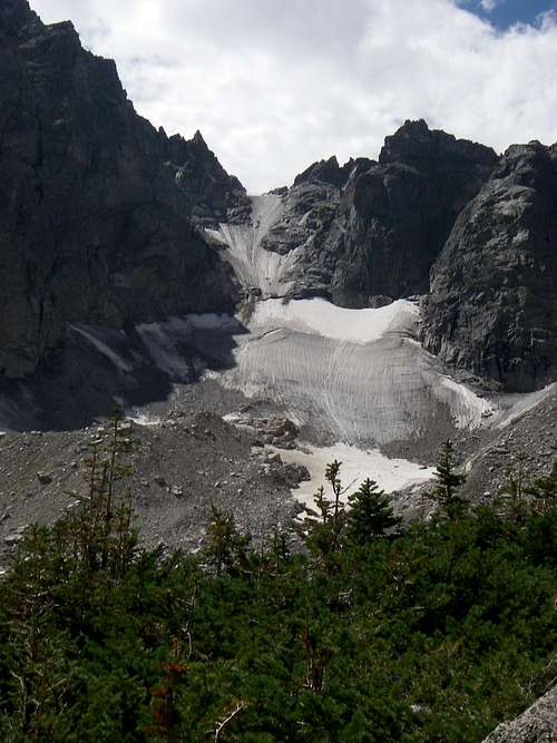
Topo Map of Route![Fair Glacier (August 12)]() View of Fair Glacier from above Triangle Lake
View of Fair Glacier from above Triangle Lake![Valley, Triangle Lake, Longs Peak]() View from top of Fair Glacier towards Triangle Lake and Longs Peak in the distance
View from top of Fair Glacier towards Triangle Lake and Longs Peak in the distance![Lake Isabelle and Long Lake]() Lake Isabelle and Long Lake from the summit of Apache
Lake Isabelle and Long Lake from the summit of Apache![Pawnee Pass: Looking West]() West side of Continental Divide from Pawnee Pass
West side of Continental Divide from Pawnee Pass Dominik and I left Boulder at 5am this Sunday to head to the Brainard Lake Recreational Area in the Indian Peaks Wilderness to climb Apache and possibly Navajo via Fair Glacier. Gerry Roach states in his Indian Peak's guide that "This is the finest mountaineering route on Apache and one of the best climbs in the Indian Peaks". After this trip I definitely have to agree: the scenery is perfect, the weather was great (mostly), and the climbing is tough, fun, and constantly changing.
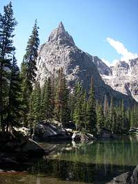
![View of Lone Eagle Peak]() Dominik enjoying the views of Lone Eagle Peak
Dominik enjoying the views of Lone Eagle PeakWe arrived at the Brainard Lake Entrance Station at 5:45am, just to notice that we had a flat tire. So after paying the entrance fee ($8) and changing the tire, we made it to the trailhead and onto the trail by 6:15. The weather was already beautiful (while still a little chilly) and there were already multiple cars at the trailhead. We made good progress up to the continental divide (Pawnee Pass), which we reached around 8am. From there we had great views down the steep west side of the Continental Divide, seeing Pawnee Lake and Lake Granby? in the distance.
We proceeded down the trail towards Pawnee Lake and then continued to our first break point where we had "lunch" and from where Dominik enjoyed our first views of Lone Eagle Peak (about 9:30am). Soon afterwards we crossed Pawnee? Creek with its cascading waterfalls (see thumbnail below) and started our second ascent of the day towards Mirror/Crater Lakes and eventually Fair Glacier.
![Lone Eagle towering above Mirror Lake]() Lone Eagle Peak from Mirror Lake
Lone Eagle Peak from Mirror Lake Despite already running behind schedule, we had to take another break at Mirror Lake to enjoy the beautiful scenery of Lone Eagle Peak towering above.
From Mirror Lake we proceeded along the trail towards Crater Lake where we followed the cairns of the Solo Flight route on Lone Eagle Peak (see thumbnail below). This lead us up a steep grassy slope and than directly along the cliffs on Lone Eagles North side until we reached a point above Triangle Lake from where we had a great view of Fair Glacier (see large picture on the right). While it had looked completely black and terrible steep from the distance, it now looked white/grey and doable.
We then left the Solo Flight trail and contoured around the right side of the basin until we reached the Glacier (see thumbnail below) at approximately 11400 feet at 11:30am. The sun was beating down on us and the weather was looking promising. Excited about our first glacier climb in years, we took a break to put on crampons and gaiters (I actually changed from trail-runners into my winter mountaineering boots).
![Lower Part of Fair Glacier]() Dominik on the lower part of Fair Glacier
Dominik on the lower part of Fair Glacier
We then proceeded to switchback up the lower portions of Fair Glacier which was icy, but due to its relatively gentle slope easy to navigate. The snow/ice conditions on the glacier were anything but perfect. Large portions were pure ice with water running down it. The remaining parts had a thin (1/2 inch) layer of corny, loose ice/snow with a solid sheet of ice below it. This meant that we had to frontpoint the steeper sections of the glacier, where we had to kick real hard to get the crampons to grip. It was also impossible to penetrate the ice layer with the ice axe, making a self arrest nearly impossible. However, I was looking for a challenge to practice my mountaineering skills, so this was perfect. (One piece of advice: Bring a helmet, we forgot ours, and Fair Glacier is quite a bowling alley!)
![Dirty Crevasse]() Crevasse in center of Glacier
Crevasse in center of Glacier
Based on our judgement the slope of the Fair Glacier is definitely below 45 degrees below the crevasse. Above the crevasse the slope is around 45 degrees and there might be a few slightly steeper sections. (We measured this holding 1 ice axe vertically on the glacier, marking the top spot and then extending it horizontally from that point towards the glacier. If the horizontal ice axe touches the Glacier, the slope is >=45 otherwise it is <45.)
![View down the upper Glacier]() View down the upper Glacier
View down the upper Glacier
Passing the crevasse at the center of the Glacier proved somewhat challenging since it extended almost completely across the glacier and was surrounded by sheets of ice parcially covered by scree. We found a small "bridge" and bypassed part of the crevasse by climbing some rocks on the left side of the glacier. Above the crevasse, the glacier steepened and we had to resort to front pointing. At this point Dominik started having cramps in his calfs. However, after a short break and a powershot, we were able to continue. For the top portion of the glacier, Dominik and I separated. Dominik stayed towards the left side and finished to top of the Glacier on rocks, while I stayed in the center of the glacier (steepest portion) and climbed all the way to the top. I would judge both variations equally difficult. However, the rocks did provide some holds and would possibly prove more forgiving during a fall.
At the top, we were beat, but exited. However, it was now after 1pm. While the weather was still nice, we could see some scattered thunderstorms developing in the distance. We took of our crampons and started heading up the obvious scree slope on the north side of Apache's west ridge. While doable, this slope was not much fun and I checked the guidebook which advised to proceed from the saddle along Class 3 ledges on the south side of the ridge. We backtracked slightly to cross the ridge to find the system of ledges. However, we were did not go all the way back to the saddle and crossed the ridge approximately 50-100 feet higher. This put us higher up on the south side of the ridge. We could have downclimbed to reach the class 3 ledges. However, we proceeded on more difficult ledges (some class 5 moves) before reaching the standard route and easier terrain. Now we had 500 feet of boulder hopping left to join Apache's south ridge and then gain the summit.
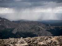
![Thunderstorm]() Approaching Thunderstorm
Approaching Thunderstorm
Having reached the south ridge we re-evaluated our situation. Aside from the weather, we were both completely exhausted, so Navajo was not an option. Looking west, we saw the thunderstorm rapidly approaching. Every once in a while we could now see a lighting strike. While always moving in the direction of Apache, the storm initially seemed to move towards Apache's north side. However, now the wind had changed directions and the storm was moving slighly south, aiming for the ridge between Apache and Navajo and therefore the East Ledges route. Thus we decided to climb over the summit of Apache (2:30pm) to descent the Queen's Way route.
![Queen s Way in August]() Queen's Way in August
Queen's Way in August
We had some good views from the summit and then hurried down towards the top of the couloir. We reached the top of the couloir as the storm reached the upper portions of Apache. We were lucky, the storm indeed passed between Apache and Navajo and we were only hit by a few drops. However, the condition of the couloir was bad, a little snow with lots of ice. To be save we faced in and front pointed the first 150 feet of the couloir until we reached gentler terrain. From there we made fast progress towards the bottom of the glacier.
We were now totally spent, having left every ounce of energy along the way. We took off the crampons (I changed back into trail runners) and proceeded down the trail in "auto pilot", one step at a time. We were exited when we finally reached the trail above the lakes. However, by now I was running blisters, 5 total (probably a combination of this being my first trip in trail runners and the use/front pointing in my winter boots, which I had not used in 6 months.) Otherwise the trip down was uneventful. We began to see other hikers and fishermen along the trail and did not stop complaining about the lengths of both Lake Isabelle and Long Lake.
13.6 miles, 5500-6000 feet, 11 hours, trail, rock, snow, ice! What a great trip!
Comments
No comments posted yet.