
-
 18291 Hits
-
 74.92% Score
-
 5 Votes
|
|
Route |
|---|---|
|
|
40.05800°N / 105.651°W |
|
|
Mountaineering |
|
|
Summer |
|
|
A long day |
|
|
Class 3 |
|
|
45deg+ Glacier |
|
|
Overview
This route is considered "the finest mountaineering route on Apache and one of the best climbs in the Indian Peaks" by Gerry Roach in his Indian Peaks Guidebook. It is a very remote and long route that combines relatively steep (45deg +) glacier travel, scramble/climbing (at least 3rd class), and some of the most beautiful scenery in the Indian Peaks. While several options exist for climbing Apache via Fair Glacier, here I will focus on a 1 day attempt from the east with a decent of one of Apache's standard routes.Alternatively, one can climb Apache via Fair Glacier from Monarch Lake or as a backpacking trip, camping at Mirror or Crater Lakes.
Note: This is a climb, not a hike!!!
Getting There
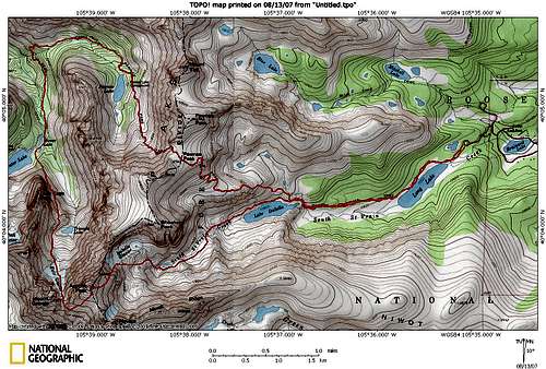 Topo Map of the Fair Glacier Route and its approach from the Long Lake Trailhead
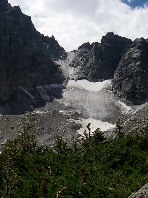 View of Fair Glacier from above Triangle Lake
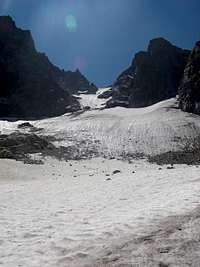
The standard, 1 day route of Fair Glacier starts at the Long Lake Trailhead within the Brainard Lake Recreational Area. The current entry fee is $8. Proceed along the standard trail toward Lake Isabelle until you reach the trail junction close to the beginning of Lake Isabelle. From there, head up the trail towards Pawnee Pass. Once you reach the continental divide (~12500feet), descent to about 10200 feet, passing Pawnee Lake and crossing the cascading waterfalls at Pawnee Creek. On this trail you will be rewarded with beautiful views of Lone Eagle Peak.
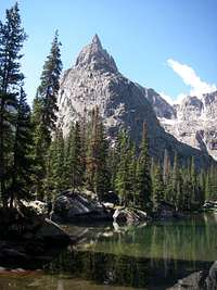 Lone Eagle Peak from Mirror Lake
Then, continue up the trail towards Mirror and Crater Lakes. Hike along the east side of Mirror lake, following a trail trough several campsites. When you reach Crater Lake, underneath Lone Eagle Peaks impressive north face, stay to the left (east) of the lake and follow the cairns of Lone Eagle Peak's Solo Flight route.
The trail proceeds below Lone Eagle Peaks cliffs on its east side, first going up a steep grassy slope and then continuing until one reaches a point above triangle Lake. From here, one has great views of the route up Fair Glacier. Contour along the bowl until you reach the bottom of Fair Glacier at approx. 11400 feet.
Alternative Route
Disclaimer: I have not done this!
To reduce milage and elevation loss, one can take an alternative route starting from Pawnee Pass, going over/past Shoshoni and descending one of its west facing couloirs towards Triangle Lake as briefly discussed here. (Thanks to brenta for providing this link!) However, while eliminating some distance and elevation loss, this route also eliminates some of the best scenery along the standard route.
Fair Glacier
 Fair Glacier from the Bottom
The complete route up Fair Glacier can be seen from the bottom of the glacier. 1-2 crevasses form in the center of the glacier. Late in the summer, the large crevasse can span the entire width of the glacier and climbers can be forced onto the rocks along the left edge of the glacier for short portions of the ascent.
Initially the glacier has very gentle slopes which steadily increase towards the crevasse (staying below 45 degrees). Above the crevasse, the glacier continues to steepen, staying around 45 degrees, with some portions towards the top being slightly steeper. Continue up the glacier to the saddle between Apache (east) and Mount George (west).
Be aware of the considerable rockfall danger on this Glacier. In addition, the conditions turn very icy in late summer. Please see the thumbnails below for more pictures from our 8/12/2007 trip.
Apache's West Ridge
From the saddle between Apache and Mount George, cross onto the south side of Apache's West Ridge and proceed upwards along 3rd class ledges until you reach the broad boulderfield on Apache's upper west slopes. Simply continue along the west ridge towards Apache's summit or join the south ridge to gain the summit.Advice: Stay low on the south side ledges when you first leave the saddle at the top of Fair Glacier to avoid 5th class terrain.
Essential Gear
Essential gear for this trip are: Ice Axe, Crampons, and Helmet.In late summer, when the glacier turns to ice, ice tools might simplify the climb.
km_donovan - Oct 4, 2009 11:36 pm - Hasn't voted
This is not a 1 day climbYou should plan to do this over two days. Take 2 ice axes or tools. The ice near the top was good however we were front pointing the last 150 vertical feet.
gsievers - Jul 31, 2019 9:14 pm - Hasn't voted
2 days fer sherjust to get to Triangle lake from the east side is big day because you are NOT going to easily find the descent route off the Divide on your first try. be prepared for 3rd or 4th Class down scrambling. see my post on mountain project for route options and pics. besides IF you're going to go this far, stop to smell the rocks, dooop I mean flowers. awesome position to find yourself and a big commitment too.