
-
 7908 Hits
-
 81.18% Score
-
 13 Votes
|
|
Mountain/Rock |
|---|---|
|
|
38.99183°N / 77.22858°W |
|
|
Trad Climbing, Toprope, Bouldering, Scrambling |
|
|
Spring, Summer, Fall, Winter |
|
|
135 ft / 41 m |
|
|
Overview

Named for a flat triangular rock formation that faces upstream and supposedly resembles a flat iron sitting on its broad end, this crag offers some challenging, solitary climbing in the midst of a very popular area.
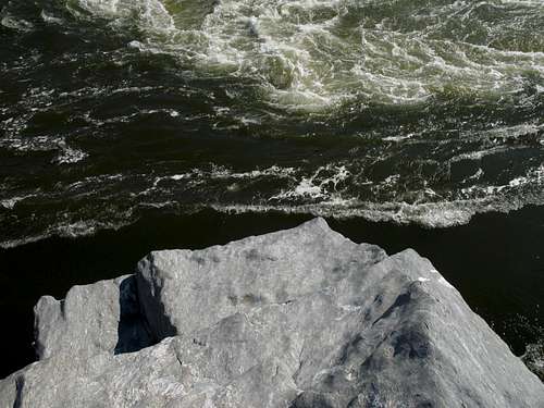
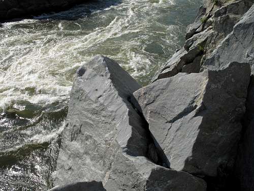
For a place located so close to such a congested metro area, this spot is exciting and wild. More than any other Great Falls crag I have been on, it exudes a feel of being high above a turbulent river into which a fall means almost-certain death. Indeed, the crag sits above S-Turn, perhaps the most challenging and dangerous whitewater (often Class 4) in Mather Gorge after the falls themselves. Most Great Falls crags have at least a narrow ledge at the bases of the climbs, but some of the routes here follow cliffs that rise directly from the river, and their bases have maybe enough room for a climber to plant his or her feet and get started.
And the routes are tough for their ratings, even the "easy" ones, and the 5.2+ Reverse Chimney is notoriously harder than it sounds. The climbs may not impress people used to the cliffs of the Sierra Nevada and southern Utah, for example, and they are short, the longest climbing just 40 feet, but that rushing river directly below some of them adds a dimension many other climbs in the area lack except during high-water conditions. The river does not make the climbs harder, but its presence does make them more dangerous, and it makes mustering the nerve to climb here a little harder to do.
The Flat Iron was a popular climbing spot from 1930-1960, but its routes are now seldom climbed (this may explain why the routes feel harder than their ratings since they have not been "updated"). That, plus the beauty of the spot, ought to entice climbers who tire of the crowds at the popular crags at Great Falls. While you're here, chances are that no one else will happen by. An occasional curious hiker may show up, but even that is unlikely as the crag is off the main trails and largely out of sight of the nearby falls overlooks.
Toproping is the norm at Great Falls, though some climbers do lead. Trad climbers need to know that custom and regulations here dictate the use of natural gear only, though, and that the smooth rock here has been known to let protection slip. And topropers should know that they will need their own setup gear here because the crag lacks the large, sturdy trees that make great natural anchors throughout so much of the Great Falls area. And for those who like something between a scramble and a rope-needed climb, there's little of that here, but I have added details and photos for an unnamed 5.2ish climb I completed on the crag.
The named routes, upstream to downstream:
•Bikini (5.5)—the low-angle face right of Bikini Corner.
•Bikini Corner (5.6)
•Excitable (5.10)—about 20 feet left of Bikini Corner. Climb the face over the river. A 5.8 variation follows the crack on the right side of the face and finishes up the nose above it.
•Reverse Chimney (5.2)—a classic example of a remaining sandbag route. More like 5.4 or 5.5, only about 25 feet.
•Flat Iron Corner (5.5)— crack route in a corner below Reverse Chimney. Smooth rock.
•Spraddle Route (5.4)— Start at Flat Iron Corner. Turn around and stem to the top of the block between the corner and the river.
•Ringbolt— It was too dangerous to look for, try, or photograph this route unroped. From Flat Iron Corner, one is supposed to move down and left to a narrow shelf just above the water (this I could do). Then go around the corner to the right, find an old canal ringbolt, and then climb the face (this part I did not do). This is a dangerous climb, so rope up even if 5.4 is easy for you. From my guidebook: “The water below this point is violent and the climber should take ample precaution not to fall in.”
•Chris’ Crack and Stocking Climb— Confusing to locate and follow. I am pretty certain I found and followed most of it, but I was using my hands, not my feet, on the thin crack, so I was a little lower than the route described in my guidebook. 50 feet downstream of Reverse Chimney, look for a crack at the top of a sloping rock (vague enough?). This is Chris’ Crack (named after Chris Scoredos, who cracked his wrist on this). Descend to a pothole (never saw it) and then traverse upstream by following a shallow, narrow crack. This is the Stocking Climb, so named for a move where a shoe was removed in order to use the crack. The climb ends a few feet left of Reverse Chimney.
No Place to Fall
5.2 Free Solo
Disappointed that the established routes here are too hard or too dangerous to take on without rope? Try this one.This climb is between Bikini Corner and Excitable, so use the approach directions for that section of the crag. I describe it from an unroped perspective here and in the captions, but it can, of course, be climbed with rope (and probably should).
The photos in this section, with their captions, will show and tell what basically has to be shown and said. I was surprised to find this unnamed and undescribed in my guide, especially since it is definitely Class 5 and is longer than most other routes on this crag. Based on other routes of similar difficulty I have free soloed, my estimation for this climb’s rating is around 5.2.
Sequence:
 |  |  |  |
Getting There
From the western part of I-495, a piece of the Capital Beltway, take Exit 44 for Route 193, Georgetown Pike; this is the second exit south of the Maryland border. Drive west for a few miles until you see the well-signed road leading to Great Falls Park. Turn right and follow the road about a mile to the entrance station. After passing the entrance station, make an immediate right and drive down to a parking area. This is the area used by most climbers and kayakers.
To reach the crag, hike toward the river for two or three minutes and then turn left for the falls overlooks. But before you get to any of them, look for breaks in a wooden fence. Follow a use trail out to the rocks and start hiking/clambering downstream until you see the crag.
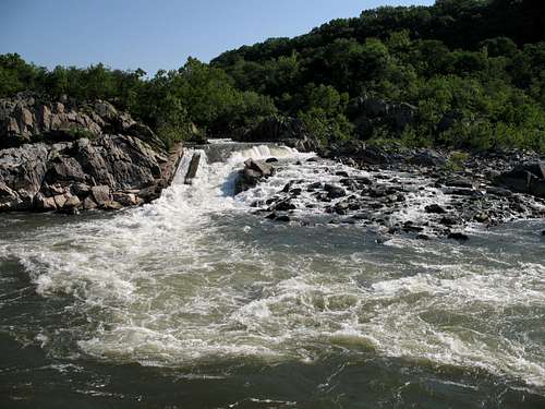
One way to know you are in the right place is to see if the fish ladder (see photo above) is directly across the river from you.
To access Bikini, Bikini Corner, and Excitable, descend a Class 3/4 gully a few yards upstream of the Bikini climbs.
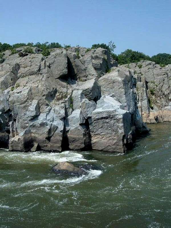
To access the others, hike around to the top of the crag and descend a crack/ledge system (Class 4 and shown in photo in this section) a few yards upstream of Reverse Chimney. To help with location, use the photo in this section that shows the view from the top of Reverse Chimney down the Spraddle Route block and to the river.
From Rocky Islands on the Maryland Side-- by hgrapid
Red Tape
The park is open from 7 A.M. until dark every day except Christmas. There is an admission fee, good for three days, of $10 per vehicle. Annual and interagency passes are also available (the latter costs $80).Climbers are required to register (free). There is a registration box at the climbers’ parking area, and there is also one at the visitor center.
Altering the rock to place gear is prohibited. Do not remove or replace existing bolts. The general rule here is that if you can't lead using natural gear, you should toprope just as most others do.
The area is popular and can be quite crowded, but I have never seen other climbers on this crag.
The park is home to copperheads. It’s unlikely that they hang out in holds on the cliffs themselves, but be aware. The danger, though slim, is greatest near the clifftops, where there are more places for snakes to be.
Poison ivy is abundant. The humid period from late spring through early fall features gnats, mosquitoes, and other biting insects.
Camping
NoneExternal Links
Great Falls NPS siteA good resource for the area is Eric Horst’s Rock Climbing Virginia, West Virginia, and Maryland. The section on Great Falls provides one-sentence overviews of the routes. There are also photos, taken either from a boat or from the Maryland side, of the crags, and the photos have useful diagrams showing the locations and directions of the routes. The guide leaves the step-by-step concerns, and the fun, to you.
An even better resource is the PATC Climbers' Guide, which focuses just on the Great Falls area. It lists more crags and routes than the other guide does, and the photos are usually better in terms of helpfulness with finding the routes.