
-
 7172 Hits
-
 83.1% Score
-
 16 Votes
|
|
Mountain/Rock |
|---|---|
|
|
38.98153°N / 77.24235°W |
|
|
Trad Climbing, Toprope, Bouldering, Scrambling |
|
|
Spring, Summer, Fall, Winter |
|
|
158 ft / 48 m |
|
|
Overview, Routes Description, and Getting There

Between Crags

Needlepoint Descent

Needlepoint Corner

Balder
Overview
Like Bird's Nest, Dr. Needlepoint could easily be the best climbing crag in the Great Falls area. The routes are long (for Great Falls-- up to about 60') and diverse, with grades ranging from a tough 5.3 to a 5.12+ that, during its mere 40' length, will thrill and challenge. The routes also vary in type-- corners, overhangs, faces, and cracks. The smooth walls and corners, in direct sunlight, also make for some of the prettiest cliffs in Great Falls. And just getting to the base without rappelling down is a small adventure in itself.
Although the crag is far from a secret and has a few very popular climbs, it is rarely jammed the way some crags closer to the parking area can be; the best routes here are too hard for the climbing schools and other large groups (scouts, church outings, etc.) that like to visit crags like Dihedrals and the Sandbox. But if you want to make sure you don't have to wait for the route you want on a nice day, get out here by 8:00.
Another nice thing about Dr. Needlepoint is that even though it has some very hard routes that are only suitable for roped climbing, it does have something beyond mere scrambling for unroped climbers. Needlepoint Descent (5.0) and Balder (5.4) are routes I have free soloed. The former is really more like a scramble; only the move at the very top feels technical at all. The latter is a real climb (more details below, and there are also photos on this page).
Routes
Routes at Dr. Needlepoint (Upstream to Downstream End; * denotes a route considered an area classic; routes in bold are ones I have done or tried):
• Inclined Plane (5.7)-- This is the last route at the upstream end of Dr. Needlepoint. Climb the face (not very hard-- easy Class 5) to access a ramp (see photo). It looks like a walk-up, but it is not; the slope is steeper than it may look, and the ramp also slants very steeply to the edge of the cliff, making this a route with some serious exposure. About halfway up, a thin crack (visible) appears along the base of the corner, but it was too thin and the exposure too great for me to risk this one unroped. If I die climbing, I want it to be on some intense mountain, not a 50' route at a local crag.
• A Bridge Too Far (5.10a)*-- Fun. Working out the bottom takes some time.
• Twin Blade (5.10a)-- One-move wonder. Climb the face or one of two converging cracks to the overhang where they meet. Pull the overhang.
• Conroy (5.7)-- Fun crux, the rest is easy.
• Escutcheon (5.11+)
• Balder (5.4)-- (45') The route climbs the crack and the corner above it. The climb, especially the first half, involves some laybacking, but the moves are not that hard because excellent holds are just about everywhere, and I was comfortable free soloing this in spite of the exposure. The lower half is also harder than the upper half is. The route is a little brushy in spots late spring through early fall. Most climbers will probably find this route very easy on a toprope, and I recommend leading or free soloing it. I did the latter.
• Wall of Da Feet (5.7-5.9)-- Slab fun.
• Needlepoint Descent (5.0)-- (50') This is, as the name implies, best-known as a descent route to the base of the Dr. Needlepoint crag, but it is a good route for scramblers who have accessed the crag from upstream or downstream approaches. It is easy to find this route from above, as it is just a few yards left (upstream) of Needlepoint Corner (see top-down view in this page's gallery). Often described as exposed and dangerous even though it's really not that bad, this 50' route goes along the right side of the pointed promontory shown in photos on this page. It starts behind, above, and left of that promontory, and the hardest move is the one at the very top. Below the promontory, the route splits so one can access either Needlepoint Corner and the climbs there or the climbs upstream of the corner. When river levels are not low, Needlepoint Descent may be the safest and even the only possible way to get to the base of the Dr. Needlepoint crag without rappelling down. Guidebooks warn that this is an exposed and dangerous route to descend unroped, but most climbers will probably find it easy and no big deal after the awkward move right at the top, which is definitely tricker descending than ascending. The move itself is about 7 or 8' in height, and a flake on the right makes it a pretty easy move when climbing up it. Going down is a little trickier since the small face overhangs slightly, but there is a long ramp beneath that should guard against a fall from the cliffs, and the move can be downclimbed by facing in, holding the edge on top, and dropping down carefully.
• Needlepoint Corner (5.3)-- Harder than 5.3. Goes on gear.
• Dr. Needlepoint (5.9)*-- This one is a blast.
• Siegfried Line (5.12+)
• Blitzkrieg (5.11+)*
• Maginot Line (5.7)-- Stiff finish. Maginot Line marks the downstream end of the named Dr. Needlepoint routes. It is just around the corner (downstream) from the Needlepoint Corner group. A scramble for 15-20 yards downstream (very difficult or impossible to when water levels are not very low) gets you to the Degree 101 crag.
Some notes about climbing at Great Falls: Most people toprope the routes, but the ratings are based on lead conditions, so topropers may think some routes are easier than their ratings suggest.
The climbs at Great Falls are short ones, but they are not sport routes. Most old bolts have been removed, and it is illegal to alter the rock by drilling or other means. Toproping is the predominant style here, but many routes are leadable. The rule at Great Falls: if you can't lead it with natural gear, toprope it just as everyone else does. This is the local ethic and was before the Park Service tightened rules about bolting and altering the rock.
Getting There
From the western part of I-495, a piece of the Capital Beltway, take Exit 44 for Route 193, Georgetown Pike; this is the second exit south of the Maryland border. Drive west for a few miles until you see the well-signed road leading to Great Falls Park. Turn right and follow the road about a mile to the entrance station. Enter and take an immediate right to reach a large parking area used by most climbers and boaters here. Don't expect to find a parking spot here after 10 on a nice weekend day.Finding the Crag
Some Great Falls crags are tricky to locate the first time since the approach is always from up top, and Dr. Needlepoint is one of them. To get there, start hiking east to the river from the climbers’ and kayakers’ parking lot (see Getting There). Before you reach the River Trail, a slightly longer but more scenic way to reach the crag, a wide gravel trail heads right. This is the Pawtomack Canal Trail, and it joins the River Trail less than half a mile south in the vicinity of the old canal cut. After you pass the cut (you can see the river through it), the trail approaches the cliffs, and shortly after you pass a boggy area (on your right) that might make Nanuls envious, marker 12 will be on the left in a well-worn clifftop area. Keep hiking a little over 100 yards past marker 12, passing one obvious clifftop area (Cornice) at 30-40 yards before reaching another, which is Dr. Needlepoint. Studying the primary image on this page and the top-down view of Needlepoint Corner may help you locate the crag. It is about 0.6 miles from the parking lot to the crag.Accessing the Crag
Unless you are going to rappell down or kayak to the crag, there are really just two options for reaching it, and one of those is highly dependent upon water levels. The first and most direct is to use Needlepoint Descent, which is easily found up top just a few yards left (upstream) of Needlepoint Corner (see top-down view on this page). The other way is to keep hiking on the River Trail until you reach the end of the cliff system where a vegetated gully makes a natural break in the rocks. This is Poison Ivy Gully (but actually relatively clear of its namesake), and it is just before the trail bends sharply right before bending sharply left again after just a few yards. Poison Ivy Gully is rated Class 3, but only one spot along it is that hard. From the base of the gully, head upstream (left). You will be passing the Degree 101 crag, which is contiguous with Dr. Needlepoint but is named separately for reasons that are discussed on its page. If water levels are anywhere from normal to high, this way may not be an option, though.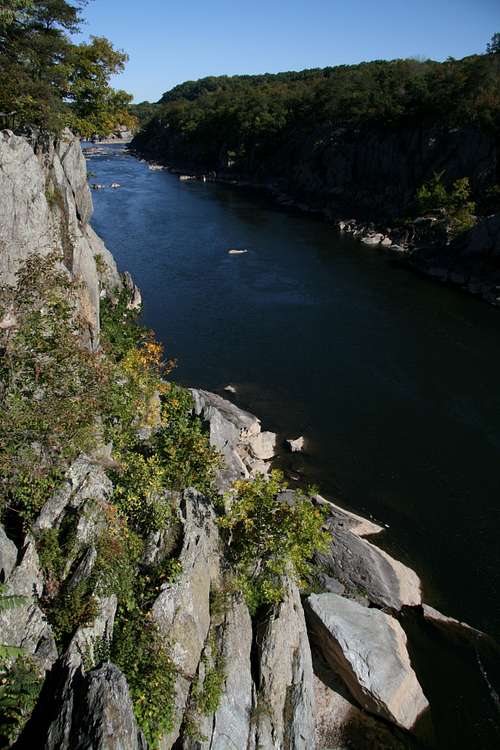
View from up top