
-
 10685 Hits
-
 80.49% Score
-
 12 Votes
|
|
Mountain/Rock |
|---|---|
|
|
38.98270°N / 77.2431°W |
|
|
Trad Climbing, Toprope, Bouldering, Scrambling |
|
|
Spring, Summer, Fall, Winter |
|
|
112 ft / 34 m |
|
|
Overview

Spitzbergen Rock resembles Spitzbergen Island in the Arctic in that there are rocks at both and water abuts each. Beyond that, I have no idea why Spitzbergen Rock is named as it is. Perhaps a Norwegian immigrant nostalgic for home saw this austere-looking crag on a raw winter day and was somehow reminded of that island far to the northeast (no offense intended to any Norwegians-- Spitzbergen is actually, believe it or not, a dream destination of mine).
Spitzbergen is actually quite striking when viewed from the south or the west. Sheer, cracked cliffs virtually devoid of vegetation reach straight up from a still, dark section of the Potomac, almost creating the appearance of a ghost ship afloat on a placid, murky sea. The rock is whiter than much of the rock surrounding it and gleams even in overcast conditions. Up close, small pinnacles and outcrops draw the eye and entice photographers, scramblers, and dreamers.
Spitzbergen is located along the first and most rugged section of the Billy Goat Trail; this section of the popular hiking and scrambling trail travels Bear Island from Great Falls of Maryland south almost to Old Angler's Inn. Bear Island forms the eastern (Maryland side) side of Mather Gorge, and the gorge is where the best climbing crags in the Great Falls area are concentrated.
To reach Spitzbergen, hike along the towpath from the parking area for about 5 minutes until you reach the southern end of Section A of the Billy Goat Trail (on your left). Follow this trail through woods and over boulder fields for about 20 minutes until you see the downstream-facing cliffs of Spitzbergen (pictured on this page) off to your left. You can find a variety of ways, ranging from Class 2 to Class 3, to reach the base of the crag. A good way to tell that you are very close to Spitzbergen is to look for Trail Marker 2, which also indicates and "emergency exit" directly back to the towpath. Spitzbergen is just a few yards beyond this marker.
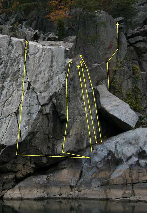
The named routes on Spitzbergen range from 5.7-5.10. The longest route, AAU Crack, is about 50' in all, but almost half is a traverse, making the vertical climb just slightly more than half that. Vertically, all the climbs range from 25 to 30 feet. Most people toprope the routes out here, and a strategically placed rope could allow one to try most of the routes in one outing, but the crack routes are leadable. Please see the photo with route diagrams included in this section; it shows and lists all the named routes on Spitzbergen.
Although there is only one established route up the river-facing wall on Spitzbergen, there are many other climbing opportunities there for those who are more interested in a fun climb than they are in following the exact steps and moves someone else put into some guidebook. Climbers choosing to enjoy Spitzbergen this way will have to rappel down to get started, but they will also get to experience the thrill of climbing directly above the river.
Scramblers and boulderers can find numerous short routes and problems on and around the crag.
Names and Diagrams of Routes
Getting There
From I-495, take Exit 41, just north of the Virginia line, heading west on the Clara Barton Parkway and then onto MacArthur Boulevard. About 3 miles from the interstate, look for Old Angler's Inn on the right side of the road. Across the road from the inn is a parking area. Park.The parking area fills early on nice weekends. Do not park at Old Angler's Inn. If the parking area is full, look for roadside parking along the south side of the road or continue along MacArthur until you reach the entrance to C&O Canal National Historical Park. There is more parking here, but you have to pay a $5 admission fee, and you will also have a longer hike to the crag.
Red Tape
No admission fees, but the area is on NPS land and all regulations for C&O Canal NHP apply (see links section).The park closes at dark. Do not alter the rock in any way to place gear. Beware poison ivy and copperheads.
Camping
NoneExternal Links
C&O Canal NPS siteAn excellent resource for the area is Eric Horst’s Rock Climbing Virginia, West Virginia, and Maryland. The section on Great Falls provides one-sentence overviews of the routes. Also, consider the PATC Climbers' Guide. It focuses just on the Great Falls area and details more crags and routes than the other guide does.