Preface.
This is an overview of my trip on May 9, 2012 to climb Mount Rogers. I am by no means a professional mountain guide or expert outdoorsman in any way. I am however an avid hiker, and mountaineer, with quite a few climbs under my belt. Please take this trip report as a guideline to help you out if you ever decide to take the time to climb this mountain yourself. I hope it helps!
How to get here.
Mt. Rogers via the Appalachian Trail from Elk Garden on Virginia Secondary Route 600.
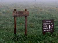
It's better to use GPS coordinates to get here... however, the GPS will sometimes try to trick you into driving through the horse gate at the entrance. Try to hold back the urge to do so, and park in the lot over by the out house restroom. Lat/Lon: 36.65970°N / 81.5447°W
If it is April-May, you may possibly see Appalachian Trail thru hikers camping in the forest right behind the parking lot. Many of them start at Springer Mountain Georgia in March, and begin this leg of their trek about this time.
Where to begin!
It was a brisk morning on May 9, 2012 when we arrived at the parking lot to knock another highpoint off of our list. It was very foggy coming up the mountain and we were hopeful that the rain would stay at bay.
We opened an old metal gate to the trail and began to follow the Appalachian trail into the highlands of Mount Rogers. It was currently not raining at this point, and we were enjoying the 50deg F temperatures on the mountain. Being the "plan ahead" type that I am, I packed two rain jackets "just in case", even though the Weather Channel said 10% chance of rain.... but that is another story!
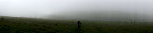
Living inside of a cloud.
About 200 feet down the Appalacian Trail.... we could no longer see our car, or the trail in front of us. It was almost as if the mountain had swallowed us whole. The only way we knew where to go was thanks in part to the white markings on rocks and posts for the Appalachian Trail. We followed this trail for a bit, and eventually came to the forest entrance. At this point, we could pretty much say goodbye to open fields.
What the trail looked like with the fog everywhere -
Foggy RogersInside the forest.
BY now, our luck had begun to run out when it comes to the rain. It started out slowly.... a few drops, not enough to make me want to put on rain gear.... but eventually, the sky opened up, and we could even hear thunder off in the distance. All of the Appalachian Trail thru-hikers commented about what a bad stretch of weather that this was. Many of them were passing us trying to push on and get out of the rain as quickly as possible.
As for the trail on the way up, the rain had turned it into small ponds and streams instead of a trail like you would think. Constantly we had to jump on rocks to avoid falling into water. The trail on the way up is about 10% streams flowing down from the top everywhere, 20% typical dirt trail, and about 70% rocks to give you an idea of what the hike is like.
This is what the lower, easier, AT looks like.Oh, the ponies.
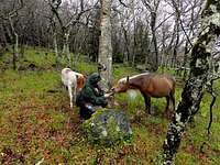
Yes, as most people know, there are ponies on Mount Rogers. About 2.5 miles up on the Appalacian Trail, we saw a group of them off to the right in the forest. It seems like they found a way to get through the fence that was setup and they made their way into the trail portion.
These ponies are very, very friendly.... but also a little pushy when they want something. If you are going to feed them something, make sure you bring alot, or you are ready to escape quickly when you are done. They will follow you, try to eat items hanging out of your backpack, and even lick you.
Click for a video of:
The Pushy Ponies.
The trail to the summit.
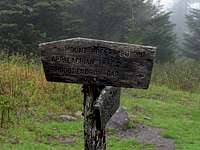
After about 4 miles of hiking the AT, you will come upon a sign that marks the trail to the top of Mount Rogers. This trail breaks off from the main AT and it's typical white markers.
The trail to the top of Mount Rogers has blue markers instead. If you keep following the white ones, you'll end up in Maine eventually!
This trail up to the top is still of the same difficulty of the rest of the trail, however, it seems to be a tad bit steeper at parts. I read many times that it is half a mile from this sign to the summit. Our GPS said that it was a little under 0.4 of a mile. This is important to note however, as once we got to the top, we were confused and unsure if we were at the correct spot due to the mileage.
The forest and fields to the top were very foggy and the rain did not let up for a moment. By now, my partner's rain jacket was starting to soak through and she was getting increasingly unhappy. She did push on however, but I could feel her eyes burning holes through the back of my jacket!
The Summit.
Finally, we turned a bend up a small hill and we were at the summit. It is marked by two Geo markers and a broken tree stump in the center of a small clearing.
Make sure you check around to find both Geo markers! There is also a path behind the summit when you come this way. I am guessing that this is the alternate route to get to
the top.
We quickly took our high point photos, ate a quick snack, talked about how it was probably more like 35deg F now, and began our trek back down.
Of course the ponies were again waiting for us... hungry as ever. This time we didnt have snacks for them and they were not pleased.... a few of them blocked the path so we couldn't get past them and we had to sneak up around them in the woods!
Fin.
It took us around 4.2 hours to complete this hike. I am certain that had the conditions been better that we would have finished this alot faster.
By the time we reached the bottom, and our car, the fog was so dense that we could barely see ten feet in front of us, and it was really starting to storm. We threw on some dry clothes and drove down the mountain.
Of course... once we descended the mountain for a few minutes it completely stopped raining and was basically sunny out. Go figure.
Overall it was a great hike and I would recommend it to anyone. It is not exceedingly difficult, as long as you watch your footing!
Thanks, and I hope this was as fun for you all to read as it was for me to hike.


Comments
Post a Comment