Introduction
Mt Mitchell, NC (6684')
Mt Rogers, VA (5729')
Sassafras Mtn, SC (3560')
Brasstown Bald, GA (4784')
Cheaha Mtn, AL (2407')
Britton Hill, FL (345')
Woodall Mtn, MS (806')
Driskell Mtn, LA (535')
Aug 5-10, 2006
All Pics
My wife and I attended the state highpointer's club convention in Asheville, NC on Aug 5 and made a grand tour of the Southeast afterward by visiting the remaining states left on the list. We rented a car from Asheville and the cheapest way to do this was to return the car at the same airport as the rental companies ding you pretty bad if you return it at another airport. This trip involved over 2,800 miles of driving, averaging about 350 miles per day! Needless to say, my wife wasn't too excited about doing some of these ho-hum highpoints, but it was the most expedient way to do it! In order to keep my lungs halfway in shape, I decided to make a hike out of NC, GA, and AL. Of these 8 highpoints, only VA requires a hike of more than 2 miles round trip.
NC- Mt Mitchell
Mt Mitchell, NC
Aug 5, 2006
~7.2 miles one-way, 4800' gain
via Colbert Ridge/Black Mtn Crest trails
Participants: Patrick Craft and Kevin Baker
My wife Jenni and I drove to the top of Mitchell 9 years ago on our honeymoon. This time I wanted to climb the East's highest peak as club member Patrick Craft from NC organized a club hike. It turned out Patrick and I were the only ones to show up and it turned out to be a fine climb. Jenni was not interested in a repeat, so she rested at the hotel until the dinner later that evening. I had to be back down to Asheville by 2pm for a club board meeting, so I only had enough time to go up and find a ride down.
Patrick was interested in taking me up the longer and rougher Colbert Ridge/Black Mtn Crest route which also goes over some other ranked Southern 6ers along the way. I was up for whatever as long as I could get back in time. We left the Colbert Ridge TH at 8:45 am as the trail initially climbs gently amidst rhododendrum, mountain laurel, and other southern plant species. The trail was well marked and we made decent time through the dense forest. The trail then steeply climbs without many switchbacks, which I have found is typical in the East. Even though temps were hovering in the low-70's, I was sweating profusely. This Colorado transplant is no longer used to the humidity and it was doing a number on me!
Once we attained the ridge, the trail moderates and skirts below Winter Star Mtn to Deep Gap at 5700'. We still had 3.7 miles to go from here but most of the vertical was out of the way. Patrick knew I would be cutting it close to get back in time, so he set a blistering pace the rest of the way. I was able to keep up with him for the most part as we didn't have to fight anymore vegetation. There were plenty of ups and downs the rest of the way as the trail climbs Potato Hill, Cattail Peak, Balsam Cone, Big Tom, and Mt Craig en route! It was cool to start the Southern 6ers list in the East as Balsam, Potato Hill, and Craig are ranked (200' rule).
We met a group of state highpointers from GA just past Deep Gap who had started earlier and began to meet the tourists coming over to Mt Craig from Mitchell. The final couple miles were enjoyable and we topped out at 12:55pm and I looked like I had just stepped out of a sauna. We took a short break and chatted with some fellow hp'ers as I found a ride down to Asheville with some hp'ers from Michigan. Patrick had enough time to head back down by himself. The only disappointing part of this hike is we were socked in clouds the entire time, so the views were nonexistent. This was the case as well when Jenni and I drove to the top in '97.
VA- Mt Rogers
Mt Rogers, VA
Aug 6, 2006
8.6 miles RT, 1500' gain
via Rhododendrum/Appalachian Trails
Jenni and I had plans on doing Rogers on our honeymoon in '97, but it was raining and we didn't have the proper gear. Fast forward almost exactly 9 years later and here we are again. This time the day looks promising and nothing will stop us from getting to the highpoint! We drove from Asheville and began the hike at around 10am on the standard route, which begins at Massie Gap (4650') in Grayson Highlands State Park. The route initially follows the Rhododendrum Trail for 1/2 mile before joining the AT along Wilburn Ridge to Rhododendrum Gap. The heavily used AT was easy to follow as expected, but we were disappointed as early on we were walking in the clouds.
The clouds lifted as we climbed, but the views were pretty average as the skies were pretty hazy. We passed only one group on the way up and talked to a ranger who was heading down. The day heated up as once again we were sweating pretty bad even though it never got warmer than the mid-70's. The gentle climb was a nice change of pace to the steep climbs I have been doing recently in CO.
![Mt Rogers]() Mt Rogers as seen from the AT with one mile to go.
Mt Rogers as seen from the AT with one mile to go.
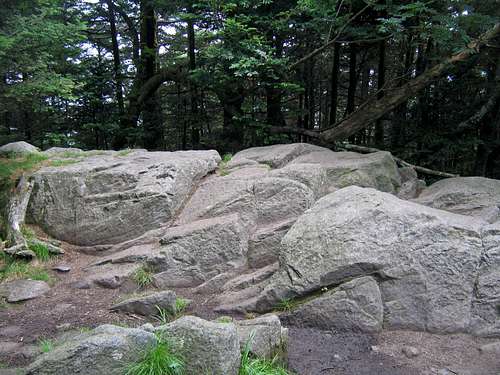
As we neared the summit, we enjoyed a respite from the sun along the spur trail off the AT as we walked through the dense forest with downed trees covered in moss. We topped out at 12:02pm and as anticipated there were no views on the summit. The true summit with the benchmark is on top of a small rock outcropping.
![VA s highpoint]() The true summit of Mt Rogers, VA's highest.
The true summit of Mt Rogers, VA's highest.
After a brief lunch, we headed back down at 12:17, hoping to jog some of the smoother sections of the trail. We came across quite a few parties on our way down. We stopped occassionally on the trail to enjoy the wild blueberries and raspberries. We were back at the car at 2:07 just as a storm was building behind us.
SC- Sassafras Mtn
Sassafras Mtn
Aug 6, 2006
Driveup
The VA and SC hp's can be done in the same day, but it is about a 4.5 hr drive between the two because of the winding roads. I missed the turnoff initiallly on County Road 199 at Rocky Bottom as it is not well marked. We made it to the top at around 7pm. This is probably the most disappointing highpoint that we did on this trip as the views were minimal and the state hasn't done much to improve the site since they purchased it from Duke Energy in late 2004, although I have heard improvements are in the works. There is a register at a kiosk and there were quite a few recent highpointer visits due to the nearby convention.
GA- Brasstown Bald
Brasstown Bald, GA
Aug 7, 2006
5.6 miles RT, 2350' gain
via Jack's Knob Trail
After a stay in W. Union, SC with relatives, we headed over to GA to do Brasstown Bald. Jenni was still trying to catchup on some sleep and was not in the mood for a hot, potentially buggy run from Jack's Gap. She decided to drive to the parking lot, after which only involves a .6 mile, 400' climb to the summit. The trail from Jack's Gap is well graded with many switchbacks but is still moderately steep as it climbs to Wolfpen Ridge. I set out at noon with a muggy 79 degree temp. The bugs were buzzing around but basically bounced off me as I could sustain a jog. The trail climbs over ranked Pt 4561, which is the 5th highest peak in GA. From there, the trail descends 200' or so to the parking lot. I met Jenni in the parking lot and we took the paved trail to the summit, arriving at 12:55.
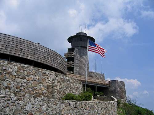
I must say the observation tower on Brasstown really impressed us. It has a nice museum with displays and there is also a nice little slide show. At the parking lot there is also a visitors center. I tip my hat to the state of GA for an impressive facility.
![Obervation tower on Brasstown]() Brasstown Bald's impressive observation tower on the summit.
Brasstown Bald's impressive observation tower on the summit.
The views on the observation tower were not all that great on this day as it once again was hazy. We met some highpointers from IL on the summit and they told us where to find the benchmark, which is behind a door below the observation deck. The jog back down to Jack's Gap was enjoyable as it is pretty smooth for the most part.
AL- Cheaha Mtn
Cheaha Mtn, AL
Aug 8, 2006
~ 1.8 miles one way, 1300' gain
via Lake and Rock Garden Trails
I found a short hiking route on Cheaha on summitpost from 1264' Cheaha Lake to the s.w. The park surrounding Cheaha Lake was closed as we arrived too early, so I had to jump the fence to access the trailhead. I found the trail behind the restrooms and set off at 9:36. The Lake Trail is well marked with blue blazes and wastes no time climbing. It was too steep and rocky to jog much of it. After about one mile, it joins the Rock Garden Trail which fizzled out at a campground. From here, I just followed the one way road to the right to the end of the loop, then up to the summit where I topped out at 10:16. Jenni was waiting for me and we toured the cool observation tower. The views were decent but once again pretty hazy.
![Observation tower on Cheaha]() The cool observation tower on Cheaha, AL's highest.
The cool observation tower on Cheaha, AL's highest.FL- Britton Hill
Britton Hill, FL
Aug 8, 2006
Driveup
After a long drive down to the southern edge of Alabama, we arrived at 3:30pm at the lowest state highpoint in the US, mighty 345' Britton Hill on the panhandle of FL. It was nearly a 5 hr drive from Cheaha. The county has recently installed a nice sign at the road and Lakewood Park is pretty nice, but it was too hot to stick around for long. The car thermometer read 97 degrees late in the afternoon and the humidity was soaring. I was sweating buckets from the 50 foot walk to the monument! The monument was pretty cool, but was not really worth the drive, but it's all out or nothing when doing state highpoints! The true highest point of Florida appears to be near a tree at the restrooms just a few yards w.s.w. of the monument. I rewarded Jenni with a trip to Pensacola Beach the next day for sticking out these highpoints with me.
MS- Woodall Mtn
Woodall Mtn, MS
Aug 9, 2006
Driveup
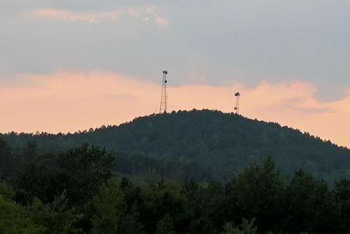
Woodall was pretty much a disappointment too as expected. There is a nice view of it on the drive up near a softball complex. It's a pretty quick drive to the summit from off of State Route 25 as we arrived just before 8pm after a long drive from Pensacola, FL. The highpoint and benchmark is inside the loop. There was quite a bit of trash at the highpoint, which was disappointing.
![Woodall Mtn on approach]() The view of Woodall from Fairground Road.
The view of Woodall from Fairground Road.LA- Driskill Mtn
Driskill Mtn, LA
Aug 10, 2006
1.8 miles RT, 150' gain
Driskill was a little more pleasant than I thought it would be as improvements have been made by a local Eagle Scout group. The route along the road was well signed at intersections and I didn't have to consult the guidebook. A short 17 minute stroll and we topped out at 2:11pm, with a temp of 97 degrees. A nice summit register post is now in place with a brand new bench. I added to the huge cairn on the summit. No views but a nice place. This ended our journey of 7 new state highpoints, which puts both of us in the "Over the Hill" club with 41 for Jenni and 45 for Kevin.


Comments
Post a Comment