
-
 3830 Hits
-
 71.06% Score
-
 1 Votes
|
|
Route |
|---|---|
|
|
46.64630°N / 12.84470°E |
|
|
Hike |
|
|
Half a day |
|
|
Walk-Up |
|
|
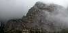
Approach
See the main page for the itineraries to the village of Niedergail.Route Description
- Start altitude: 1108m
- Summit altitude: 2162m
- Prevailing exposition: W
- Type: 2h over forest roads. 1h over paths
- Protection: marked
From Niedergail take trails 18 and 441 southward through the Niedergailer Tal Valley. Until you reach Krauthner Hütte at 1457m the hike follows a forest road. From there on it gest steeper and climbs for Gailtaler Alm.
Here turn east onto trail No 03, the "Karnischer Höhenweg" Trekking Trail. At first going level it suddenly heads up to the Kreuzleitjoch Pass. Here turn northward and follow trail No 440 to Säbelspitz Stallonkofel and Runseck. Only a short section between Stallonkofel and Runseck is a little exposed.
 |  |  |  |  |