
-
 17306 Hits
-
 75.04% Score
-
 6 Votes
|
|
Route |
|---|---|
|
|
19.18330°N / 98.6333°W |
|
|
Easy Glacier Climb and Scramble |
|
|
Half a day |
|
|
II, PD-, 40 degrees |
|
|
Approach
1) La Joya to Ayoloco Hut -- 4 to 6 hours (Easy hiking over fields and glacial moraines). Trail is poorly marked and quite tiring but water is usually plentiful. An alternate approach is also available which traverses higher on the mountain, as described below by esugi. This approach requires some 3rd class scrambling.
OR
2) Nexcoalanco to Ayoloco Hut -- Time and conditions unknown (at least 3 hours).
According to Secor, for "climbers of moderate experience," this route is preferable to the normal route since it is more direct and does not pass over any false summits. This is only partially correct, however. It is certainly true that the summit day is quite short and direct, requiring only about 500 m of climbing and about 3 hours. The approach, however, is significantly longer and more obscure than the approach to the huts at the knees. The walk is quite beautiful though and lacks the crowds found during the high season on the normal route. When I climbed the route, we were the only party at the hut and on the glacier. Sadly though, the glacier has receeded significantly in recent years and is no longer the moderate route that it may once have been. It is now quite straightforward and requires only solid cramponing skills. Thus, while possibly perferable because of its solitude, climbers should consider carefully whether the difficult approach is worthwhile.
The climb begins at the Ayoloco Hut (4,680 m), which can be reached by a poorly marked trail which runs on the western side of the mountain. This trail can be accessed from either the south (via La Joya) or the north (via Nexcoalanco), with the south being more popular.
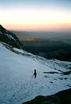
1a) La Joya to Ayoloco Hut -- Click here for a photo showing the approximate route.
From the yellow registration box at La Joya, two prominent trails can be found. The higher, which leads up the slope to the right, heads to the huts at the knees and the normal route. Take the lower trail which traverses first along the hillside and then drops gradually to the Tlaltipatango Valley below. Several scattered trees can be seen below as well as a large rock about half-way up the opposing ridge (the rock is known as "Boca de Tiburon" or shark's mouth). Head down into the valley, passing between several large trees and crossing over streams. Climb towards Boca de Tiburon and then aim for the lowest point on the ridge (above and to the left). There is no clear trail but any of the many "cow paths" will suffice.
From the top of the ridge, a somewhat obscure path traverses down and to the right towards a large rock wall. More streams are crossed and the path stays high and close to the rock wall (probably about 50-100 m from the wall). Be very careful not to be drawn too low, as there are additional trails lower on the mountain which will also get you to the hut eventually, but with much more difficulty. Look for toppled cairns along the way and follow the path to a prominent break in the rock wall, marked by a large cairn and some orange paint on the rocks. It is critical to locate this passage, since after this point, cairns can always be located, albeit sometimes with great difficulty. See the Route Overview Photo below for the approximate route and location of the passage.
After climbing through the gap in the rock, strain your eyes to search for cairns and always stay high. The trail traverses at around 4,100 to 4,200 m. Do not be tempted to go lower and take the time to find the cairns. Follow the cairns over a number of small ridges and ravines (often containing water). The trail continues to rise gradually, with the knees being visible above. Eventually, a huge moraine is reached which seems to drop directly from the knees. This is actually the moraine which separates the Knees glacier and Ayoloco glacier. Follow cairns up onto the moraine crest. Once you have gained the ridge, the route to the hut is clear and marked regularly with cairns. Getting onto this ridge and finding the earlier passage through the rock wall are the key route finding elements. Should you happen to lose the route, however, the moraine crest can also be gained lower on the mountain.
From this point, simply follow the well-marked crest of the moraine until the hut comes into view. The hut is quite nice, with room for about 6 guests and a shelf for cooking. Snow was plentiful around the hut and the upper sleeping shelf was quite warm. A window facing west gives a great view of the vast expanse of lights representing Mexico City.
1b) La Joya to Ayoloco Hut (Alternate) --Submitted by esugi on Feb 28, 2004 -- Click here for a photo showing the approximate route.
I read and studied the route described by Tom Fralich on the approach to the Ayoloco Hut. Then I was informed by another member of summit post that there is actually an alternate approach to the Hut. I just came back from climbing Izta (2/19/04) and we approached the hut using this alternate approach.
Take the lower trail from La Joya and drop down into the Tlaltipatango Valley below. Go across the valley and up the opposite face towards the "first saddle". Follow the many "cow paths". Everything is same up to this point. See my pics.
Now, at about 13,500 ft, hang a right towards the second saddle following the many more "cow paths". At the top of the second saddle, you will encounter class 3 rocks. Once you climb over the second saddle, you'll be at about 14,500 ft. You'll also see a memorial cross. See my pics.
From there, you'll see an obvious scree slope up and to the left (facing Izta). There are several trails leading to the scree slope so just pick one. At the top of the scree slope, you'll be at about 15,000 ft. See my pics.
At the top of the scree slope, you'll notice a ridge directly across. Climb up and over this ridge and traverse across few hundred feet. The hut will come into view very shortly at about 15,200 ft. See my pics.
I can not tell you if this approach is easier then the one described by Tom Fralich. From La Joya to the hut took us little less than 5 hours. This included at least one hour in breaks and carrying 45-55 pound packs (including 10 liters of water!) We carried all the water for one night stay at the hut. We crossed only one stream but this was in the Tlaltipatango Valley. Not much help when you're camping some 2000 vertical feet from there. A lot of snow patches around the hut, thanks to the recent snow storm but in drier years, finding snow to melt could be difficult. If you're climbing earlier in the season (Nov, Dec), snow should not be difficult to find, I would think.
 |  |  |
Route Description
Ayoloco Hut to El Pecho (Summit) -- 600 m, 3 hours (Easy glacier to 40 degrees), 1.5 hours to descend.
The route from the Ayoloco Hut to the glacier will vary greatly depending on snow conditions but should be straightforward. From the hut continue following the moraine crest upwards and then traverse left into the gully which leads to the start of the glacier. When we climbed the route, an obvious slip of snow in the upper secion of the gully provided easy access to the glacier. When more snow is on the mountain, it may be convenient to drop into the gully sooner to avoid the loose rock on the moraine.
Once on the glacier, the easiest route follows a rising traverse from right to left to reach the low point on the ridge above. There are two large rock groups in the center of the lower glacier which may be visible, and if so, it is convenient to pass between them. Afterwards, continue traversing left towards some more rock and gravel (may be snow covered) and turn right to follow a more direct line to the ridge above. Upon reaching the ridge, there should be less snow and there are some nice flat areas where backpacks can be left for the final climb to the summit.
From this point, the route follows La Arista del Sol (Normal Route) for about 200 m to the summit. Simply follow the ridge upwards (some easy scrambling is required) to reach the summit snow dome.
A number of other lines could also be taken on the glacier, with the steepest being found to the extreme right when facing the glacier from the hut. When we climbed, there was what looked to be 30 m of water ice at about WI 4 which dropped from the ridge on the right side of the glacier. It could easily be climbed with two ice tools and a couple of screws.
 |  |  |  |
Essential Gear
An ice axe and crampons are recommended for this climb since the snow on the glacier can be quite firm and is easier to climb and descend with crampons. Despite Secor's description, no "crevasses or ice cliffs" were encountered so a rope is probably not necessary for those with good cramoning skills and self-arrest training. However, I can not be certain that there are never any crevasses on the route. For novice climbers who lack confidence of moderate snow slopes, the rope is a good idea.
Web Info
Information on the approach and climb are also provided at http://www.xpmexico.com, but I found the descriptions to be outdated and incomplete.
Miscellaneous Info
If you have information about this route that doesn't pertain to any of the other sections, please add it here.
esugi - Feb 28, 2004 5:47 pm - Hasn't voted
Route CommentI read and studied the route described by Tom Fralich on the approach to the Ayoloco Hut. Then I was informed by another member of summit post that there is actually an alternate approach to the Hut. I just came back from climbing Izta (2/19/04) and we approached the hut using this alternate approach.
Take the lower trail from La Joya and drop down into the Tlaltipatango Valley below. Go across the valley and up the opposite face towards the "first saddle". Follow the many "cow paths". Everything is same up to this point. See my pics.
Now, at about 13,500 ft, hang a right towards the second saddle following the many more "cow paths". At the top of the second saddle, you will encounter class 3 rocks. Once you climb over the second saddle, you'll be at about 14,500 ft. You'll also see a memorial cross. See my pics.
From there, you'll see an obvious scree slope up and to the left (facing Izta). There are several trails leading to the scree slope so just pick one. At the top of the scree slope, you'll be at about 15,000 ft. See my pics.
At the top of the scree slope, you'll notice a ridge directly across. Climb up and over this ridge and traverse across few hundred feet. The hut will come into view very shortly at about 15,200 ft. See my pics.
I can not tell you if this approach is easier then the one described by Tom Fralich. From La Joya to the hut took us little less than 5 hours. This included at least one hour in breaks and carrying 45-55 pound packs (including 10 liters of water!) We carried all the water for one night stay at the hut. We crossed only one stream but this was in the Tlaltipatango Valley. Not much help when you're camping some 2000 vertical feet from there. A lot of snow patches around the hut, thanks to the recent snow storm but in drier years, finding snow to melt could be difficult. If you're climbing earlier in the season (Nov, Dec), snow should not be difficult to find, I would think.
Tom Fralich - Mar 2, 2004 12:33 pm - Hasn't voted
Route CommentThanks for the info. I remember seeing a higher path that split off just as we were leaving the hut during our descent. This is probably the route which you have described. Good job on the description. I've incorporated the info onto the Ayoloco Glacier page.
Jmarks07 - Apr 7, 2018 12:04 pm - Hasn't voted
Conditions as of Jan 2018I made the approach to the hut twice this January (once as an acclimatization hike and once to relocate to high camp). As of now, the secondary route proposed by Esugi is certainly the most obvious route, particularly for the descent. Note that the Ayoloco glacier is now basically just a big snow patch. Be sure to bring crampons as the ice is rather hard, and be careful later in the day, as there is a real risk of punching through the snow to the rocks and meltwater below. This route is still tremendously worthwhile due to its isolation and beauty. Tom's approach, by the way, is much more fun than the other route, due to the waterfalls and superior position on the mountain to see good views into the valley below. Hut is in good condition but is now inhabited by a rather cunning mouse. Keep your food well sealed or hang it while sleeping.